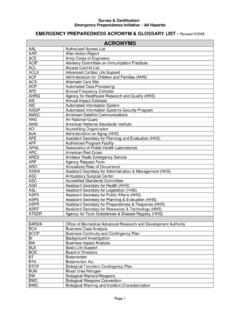
ACRONYMS
Automated Information Systems Security Program. AMSC : American Satellite Communications. ANG: ... Geographic Information System. GISRA. Government Information Security Reform Act. GSA. ... Handbook of Information Security Management. HMO. Health Maintenance Organization. HPP . Hospital Preparedness Program (HHS) ...
Download ACRONYMS

Information
Domain:
Source:
Link to this page:
Documents from same domain
Medicare Benefit Policy Manual
www.cms.govMedicare Benefit Policy Manual . Chapter 15 – Covered Medical and Other Health Services . Table of Contents (Rev. 241, 02-02-18) Transmittals for Chapter 15
DEPARTMENT OF HEALTH AND HUMAN SERVICES …
www.cms.govform cms-116 (09/17) 2 city, state, zip code . name and address/location tests performed/specialty/subspecialty name of laboratory or hospital department
Avoiding Medicare Fraud & Abuse: A Roadmap for …
www.cms.govAvoiding Medicare Fraud & Abuse: A Roadmap for Physicians MLN Booklet Page 3 of 21 ICN 905645 November 2017. INTRODUCTION. Most physicians strive to work ethically, provide high-quality medical care to their patients, and submit
State Operations Manual - Centers for Medicare …
www.cms.govState Operations Manual . Appendix PP - Guidance to Surveyors for Long Term Care Facilities. Table of Contents (Rev. 173, 11-22-17) Transmittals for Appendix PP
Medicare Claims Processing Manual - Centers for …
www.cms.govMedicare Claims Processing Manual . Chapter 12 - Physicians/Nonphysician Practitioners . Table of Contents (Rev. 3971, 06-13-18) Transmittals for Chapter 12
Medicare National Coverage Determinations Manual
www.cms.govAfter examining the available medical evidence, the Centers for Medicare & Medicaid Services determines that no national coverage determination is appropriate at this time.
Center for Clinical Standards and Quality /Survey ...
www.cms.gov6. Interviews with Prescribers. None of the guidance to surveyors should be construed as evaluating the practice of medicine. Surveyors are instructed to evaluate the process of care.
news brief - Home - Centers for Medicare & …
www.cms.gov1. news brief. Transforming the lives of nursing home residents through continuous attention to quality of care and quality of life. VOLUME 1 / 2013
CPOE for Medication, Laboratory and Radiology …
www.cms.govlicensed healthcare professional or certified medical assistant to create the first record of that order as it becomes part of the patient’s medical record, ...

Transmittals for Chapter 14 - Centers for Medicare …
www.cms.govMedicare Program Integrity Manual . Chapter 14 - Reserved for Future Use. Table of Contents (Rev. 491, 11-22-13) Transmittals for Chapter 14
Related documents
GEORGIA STORMWATER MANAGEMENT MANUAL
documents.atlantaregional.comVolume 2 (Technical Handbook) Georgia Stormwater Management Manual iii ... 9.3 Geographic Information Systems .....9-4 9.3.1 Introduction ... 9.5.2 Digital Orthophoto Quarter Quadrangles.....9-10 9.5.3 Remote Sensing ...

Reading Essentials and Note-Taking Guide
ppisdcoachbailey.weebly.comgrams called geographic information systems (GIS) to make maps. A GIS accepts data from different sources—maps, satellite images, printed text, and statistics—and converts the data into digital code, which arranges it in a database. With GIS, each kind of information on a map is saved as a separate electronic layer.

Certified Employment Support Professional
apse.orgGeographic Scope The CESP is only offered in the United States at this time. While international candidates are welcomed, the examination was created using a Role Delineation Study process that studied best practices in the United States. In addition, the examination in its current forms reference US specific laws and systems.
Get help and support A-LEVEL GEOGRAPHY - AQA
filestore.aqa.org.ukVisit our website for information, guidance, support and resources at aqa.org.uk/7037 If you'd like us to share news and information about this qualification, sign up for emails and updates at aqa.org.uk/keepinformedgeography Alternatively, you can call or email our subject team direct. E: geography@aqa.org.uk T: 01483 477 791
“GIS APPLICATION IN AGRICULTURAL DEVELOPMENT”
kilimotrust.orgHandbook on geographic information systems and digital mapping (2002) Series F No. 79 Page 8 of 112 Introduction and Advanced GIS application Agricultural Development

e-Government Procurement Handbook
www.adb.orgBy making any designation of or reference to a particular territory or geographic area, or by using the term ... 1.2 e-Government Procurement Systems Plotted on Timescale 8 ... 8.2.2 Digital Signature Certificates 108 8.3 User Profile and Authorization Management 108

FLORIDA LAND USE, COVER AND FORMS CLASSIFICATION …
www.pinellas.wateratlas.usf.eduimages is entered into a Geographic Information System facility. The Geographic Information System is a computer-based mapping facility which enables the Geographic Mapping Section to record both image and non-image geographic information in a digital format. The System supports a large number of registered mapping levels or planes, each of