Basic Principles of Inertial Navigation
3 A few definitions • Inertiais the property of bodies to maintain constant translational and rotational velocity, unless disturbed by forces or torques, respectively (Newton’s first law of motion). • An inertial reference frame is a coordinate frame in which Newton’s laws of …
Download Basic Principles of Inertial Navigation
Information
Domain:
Source:
Link to this page:
Documents from same domain
Radiation Detection and Measurement - Atlas …
atlas.physics.arizona.eduRadiation Detection and Measurement Range of charged particles (e.g., !: µm; ": mm) Range of high energy photons (cm) Two main types of interactions of high energy ...
Chapter 9 CALIBRATION OF PHOTON AND ELECTRON BEAMS
atlas.physics.arizona.edutheories (see Chapter 2 and Section 9.4 in this chapter). The sensitive air volume or mass in an ionization chamber is determined: Directly by measurement (the …
Decay Schemes - NucleonicaWiki
atlas.physics.arizona.eduschemes are an aid to understanding the contents of the nuclide chart boxes. More diagrams can be found in the new brochure for the 8th Edition of the Karlsruhe Nuclide Chart which can ... The colour red indicates that the nucleus decays by electron capture / positron emission.
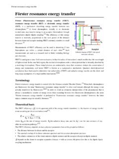
Förster resonance energy transfer
atlas.physics.arizona.eduIn fluorescence microscopy, fluorescence confocal laser scanning microscopy, as well as in molecular biology, FRET is a useful tool to quantify molecular dynamics in biophysics and biochemistry, such as protein-protein interactions, protein–DNA interactions, and protein conformational changes. For monitoring the complex formation
Introduction to Cosmology - University of Arizona
atlas.physics.arizona.edumology course at The Ohio State University. The students taking the course were primarily juniors and seniors majoring in physics and astronomy. In my lectures, I assumed that my students, having triumphantly survived fresh-man and sophomore physics, had a basic understanding of electrodynamics,
The Klein-Gordon equation - University of Arizona
atlas.physics.arizona.edugiving the relativistic energy-momentum relation In the system of natural units The four-scalar in eq.(1) The scalar meson field Goal: to determine the fundamental equation of motion for a field F(R,t) . F(R,t) is a scalar field for relativistic, spinless particles of nonzero mass m = meson field.
Gamma-Ray Spectroscopy Using A NaI(Tl) Detector
atlas.physics.arizona.edu9. Make a plot of the photopeak energies for 137Cs and 60Co versus channel number and generate a calibration curve with which you can convert channel number to energy for later exercises. Exercise II - Analyses of the 137Cs and 60Co Gamma-Ray Spectra:
VHDL Syntax Reference
atlas.physics.arizona.eduVHDL Syntax Reference By Prof. Taek M. Kwon EE Dept, University of Minnesota Duluth This summary is provided as a quick lookup resource for VHDL syntax and code examples. Please click on the topic you are looking for to jump to the corresponding page. Contents 1.
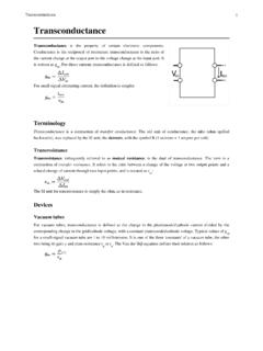
Transconductance - University of Arizona
atlas.physics.arizona.eduA basic inverting transresistance amplifier can be built from an operational amplifier and a single resistor. Simply connect the resistor between the output and the inverting input of the operational amplifier and connect the non-inverting input to ground. The output voltage will then be proportional to the input current at the inverting input,
Lecture 4 Scattering theory - University of Arizona
atlas.physics.arizona.edu3 Scattering cross section The differential cross-sectionfor scattering is defined as the number of particles scattered into an element of solid angle dΩin the direction (θ,φ)per unit time : The total cross-section corresponds to scatterings through any scattering angle: [dimensions of an area] (1.2) (1.1) Ω Ω σϑφ d dN J 1 d d ( , ) sc inc = Most scattering experiments are carried out ...
Related documents

Surveying - traverse - web - Memphis
www.ce.memphis.eduSurveying - Traverse Group Example Problem 1 B A D C S 77° 10’ E 651.2 ft. S 38° 43’ W 826.7 ft. N 64° 09’ W 491.0 ft. N 29° 16’ E 660.5 ft. Side Length (ft.) Latitude Departure degree minutes AB S 77 10 E 651.2 BC S 38 43 W 826.7 CD N 649W 491.0 DE N 29 16 E 660.5 Bearing Surveying - Traverse Group Example Problem 1 Surveying ...

Pathway guide Quantity Surveying and Construction
www.rics.orgPathway guide Quantity Surveying and Construction 6 1 2 3 4 5 Quantity surveyors are the cost managers of construction. They are initially involved with the
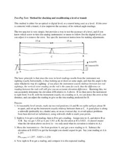
Two-Peg Test: Method for checking and recalibrating a ...
geog.sfsu.eduA-B. Say we get 1.524 at A and 1.501 at B, the elevation at B is 0.023. (It doesn't matter what the elevation above sea level is – we only need what its elevation is relative to A.) 3. Move the instrument to ~3m from position A, and get a new reading to A. Subtract the elevation at B (0.023) to get the foresight you should expect to get.
A Guide for Consumers - California
www.bpelsg.ca.govprofessional engineering or land surveying services only if they are working under the direction of a licensed engineer or land surveyor. •See page 14 to learn how to check on the license of any engineer or land surveyor you are thinking of hiring. Know …

Guidelines for the use of GNSS in surveying and mapping
www.rics.orgThe document is divided into two parts. Part 1 summarises the important criteria to be considered in GNSS surveying, and includes guidelines for best practice. Part 2 is a technical explanation which develops the themes of Part 1 in a more formal context. This is primarily intended for surveyors and clients who wish to understand some GNSS ...

INTRODUCTION TO ENGINEERING SURVEYING (CE 1305) …
www.tanliatchoon.yolasite.com(1) design highways, railroads, canals, sewers, water supply systems, and other facilities having grade line that best ... A surveying operation carried out to determined the elevation of points or to find the difference in elevation of points. 6. Uses of Levelling
SURVEY FIELD PROCEDURES MANUAL Prepared By THE …
www.roads.maryland.gov1-01 Introduction A. Definition of Surveying 1.1.1 B. Importance of Surveying 1.1.1 C. Purpose of Manual 1.1.2 D. Scope of Manual 1.1.2 1-02 Organization A. Division of Plats and Surveys 1.2.1 B. Duties and Responsibilities 1.2.5 1-03 Public and Internal Relations A. General 1.3.1 B. Relations With the Public 1.3.1 C. Relations with Property ...

Standards & Procedures for Surveying and Mapping
ogs.ny.govSurveying Standards and Procedures Manual. 1) The New York State Plane Coordinate System shall be used on all surveys unless specifically instructed not to by the OGS . 2) Before commencing any field survey, every attempt should be made to contact all owners of property adjoining the parcel to be surveyed.