
Cambridge O Level
2 UCLES 2021 2059/02/O/N/21 1 Study Fig. 1.1, a map showing the natural topography of southern and western Pakistan. Key land height in metres 3000+ 1000–2999 500–999 0–499 international boundary river city N 0 100 200 300 km Arabian Sea IRAN AN INDIA Quetta
Download Cambridge O Level

Information
Domain:
Source:
Link to this page:
Documents from same domain
2059 PAKISTAN STUDIES - Past Papers | GCE Guide
papers.gceguide.com2059 PAKISTAN STUDIES 2059/01 Paper 1 (History and Culture of Pakistan), maximum raw mark 75 This mark scheme is published as an aid to teachers and candidates, to indicate the requirements of the examination. It shows the basis on which Examiners were instructed to award marks. It does not
Cambridge IGCSE - GCE Guide
papers.gceguide.com4 LE 2020 062504P23 3 Fig. 3.1 shows solar cells that use radiation from the Sun to generate electrical power. Fig. 3.1 (a) (i) State the name of the process which releases energy in the Sun. [1] (ii) Describe what happens in this process. [2] (b) Apart from solar cells, there are other energy resources used on Earth for which the radiation from the Sun is the main source.
IGCSE English 0500/21 Insert May/Jun 2021
papers.gceguide.com2 ULES 2021 0500/21/INSERT/M/J/21 Read both texts, and then answer Question 1 on the question paper. Text A: Green shopping won’t save the planet The following text is an article about individuals and the environment. It’s easy being green … too easy.
ENGLISH AS A SECOND LANGUAGE 0511/22
papers.gceguide.comThe zoo where Karin currently works plays an important role in animal conservation – there are ... he was mainly interested in – at that time, collecting autographs was a popular hobby. Pedro says ... beginning ‘Dear Pedro…’ that the director had written to him. C
IGCSE, Physics, Paper 4 Theory (Extended), 0625/42, Jun21
papers.gceguide.com5 UCS 2021 0625/42/M/J/21 [Turn over 3 Fig. 3.1 shows water flowing at very slow speed over a cliff edge. water rocks 15 m cliff edge Fig. 3.1 The water falls 15 m onto the rocks below. (a) Show that the velocity of the water when it strikes the rocks is 17 m / s. [4] (b) 30 kg of water flows over the cliff edge every second. Calculate the force exerted by the rocks on the falling water.
FIRST LANGUAGE ENGLISH 0500/22 - GCE Guide
papers.gceguide.comCambridge IGCSE DC (JC) 181573/1 ... This document has 12 pages. Blank pages are indicated. *9482520056* FIRST LANGUAGE ENGLISH 0500/22 Paper 2 Directed Writing and Composition May/June 2020 2 hours You must answer on the question paper. You will need: Insert (enclosed) ... 0500/22 FIRST LANGUAGE ENGLISH - Question Paper June 2020 Author ...
FIRST LANGUAGE ENGLISH 0500/22
papers.gceguide.com2 UCLES 2021 0500/22/M/J/21 Read Text A and Text B in the insert and then answer Section A, Question 1 on this question paper. Section A: Directed Writing Question 1 Write a magazine article for young people about modern friendship. In your article you should:
Cambridge O Level
papers.gceguide.comM marks are method marks upon which further marks depend. For an M mark to be scored, the point to which it refers must be seen in a candidate's answer. If a candidate fails to score a particular M mark, then none of the A marks that follow can be scored. B marks: are independent marks, which do not depend on other marks.
0417 m21 ms 21 - GCE Guide
papers.gceguide.comTawara Electrical Supplies Fuses 20mm 315ma Anti-surge £0.14 15 £2.10 -1 Tawara Electrical Supplies Fuses Mains 3 Amp £0.10 11 £1.10 -1 Tawara Electrical Supplies Kf25 Carrier (pf-110-025-t) £1.86 20 £37.20 -1 Tawara Electrical Supplies Kf25 Clamp (pf-100-025-t) £2.45 16 £39.20 …
CAIE; GCSE; 0580/31; Mathematics; Paper 3 (Core)
papers.gceguide.com12 U 2020 05803120 6 11 cm 140° NOT TO SCALE C B H F E A G D O The diagram shows a circle, centre O, radius 11 cm. C, F, G and H are points on the circumference of the circle. The line AD touches the circle at C and is parallel to the line EG. B is a point on AD and angle ABO = 140°. (a) Write down the mathematical name of the straight line AD. [1] (b) (i) Find, in terms of …
Related documents
Cambridge International June 2022 Final Timetable Zone 3
www.cambridgeinternational.orgOL Pakistan Studies 2059/02 1h 30m AM AS French Language 8682/22 1h 45m AM AS Thinking Skills 9694/12 1h 30m AM AL French 9716/22 1h 45m AM Thursday 28 April Syllabus/Component Code Duration Session IG Literature (Spanish) 0488/31 1h 20m PM IG Cambridge International Mathematics (Core) 0607/31 1h 45m PM
Syllabus Cambridge O Level Pakistan Studies 2059
www.cambridgeinternational.org6 Cambridge O Level Pakistan Studies 2059. Syllabus for examination in 2022. 3. Syllabus content at a glance All candidates study: The history and culture of Pakistan • Cultural and historical background to the Pakistan Movement • The emergence of Pakistan 1906–47 • Nationhood 1947–99 The environment of Pakistan • The land of Pakistan
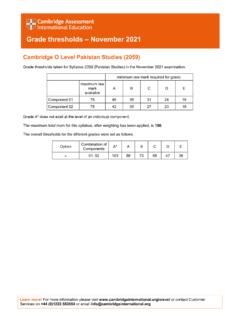
Cambridge O Level Pakistan Studies (2059)
papers.gceguide.comCambridge O Level Pakistan Studies (2059) Grade thresholds taken for Syllabus 2059 (Pakistan Studies) in the November 2021 examination. minimum raw mark required for grade: