
Chapter 4 - Photogrammetry
GIS Geographic Information System GNSS Global Navigation Satellite System (See also the application of GPS in this document.) GPS Global Positioning System (In this document it refers generically to space satellite system positioning. See Chapter 3 for application of specific space satellite systems.) GSD Ground Sampling Distance
Download Chapter 4 - Photogrammetry

Information
Domain:
Source:
Link to this page:
Documents from same domain
Basic Highway Plan Reading - index html
www.codot.govBasic Highway Plan Reading Inspector ... The Standard Specifications, ... standard design and construction practices which are utilized on all projects.
COLORADO DEPARTMENT OF TRANSPORTATION …
www.codot.govcolorado department of transportation staff bridge bridge rating ... – reinforced concrete structures ... 8-4 rating concrete bridges with unknown reinforcing ...
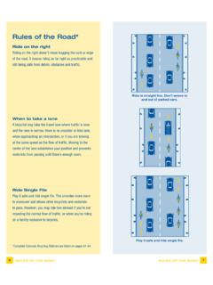
Rules of the Road* - CDOT
www.codot.govRules of the Road* Ride on the right Riding on the right doesn’t mean hugging the curb or edge of the road. It means riding as far right as practicable and

for Road and Bridge Construction - CDOT
www.codot.govi Colorado Department of Transportation Standard Specifications for Road and Bridge Construction 2011
Work Zone Safety and Mobility Rule - CDOT
www.codot.govPage 4 of 58 Traffic Control Plan (TCP) Construction phasing greatly affects the safety and mobility of work zone users. It is important that designers and construction engineers who …

STUDIES OF ENVIRONMENTAL EFFECTS OF MAGNESIUM …
www.codot.govEven very close to the roadway, the potential of magnesium chloride deicer to cause environmental damage is probably much smaller than that of other factors related to road use and maintenance, including pollution of highway surfaces by
Associated Press Style - CDOT
www.codot.govAssociated Press Style Quick Reference Guide To subscribe to The Associated Press Stylebook online, or to find out about purchasing hard copies of the book, start here. To find out about StyleGuard for Word, start here. For slide presentations of AP Style basics, go here.
15 Load and Resistance Factor Rating LRFR - index html
www.codot.govThe Notional Rating Load (NRL) and Lane Type Legal truck for spans greater than 200 feet as specified in the AASHTO Bridge Evaluation Manual shall be included in the posting analysis.
00 Introduction Final - CDOT
www.codot.govApril 1, 2011 Introduction Page 4 of 4 The HL-93 load rating for the Load and Resistance Factor Rating (LRFR) method is reported as a rating factor. All other ratings are reported as a rating ... Bridge Rating Manual (see AASHTO LRFD 4.6.3.1, modified here as …

COLORADO DEPARTMENT OF PUBLIC HEALTH AND …
www.codot.govColorado Department of Transportation Compliance Order on Consent Page 1 of 28 COLORADO DEPARTMENT OF PUBLIC HEALTH AND ENVIRONMENT WATER QUALITY CONTROL DIVISION
Related documents

VFR Navigation Log (Jeppesen)
sethlake.aeroNavigation Satellite System (GNSS) equipped aircraft with ocianic, enrout, terminal, and GPS approach capability. /B-DME, transponder with no altitude encoding capability /A-DME, transponder with altitude encoding capability /R-RNAV, …

NAVSTAR, the Global Positioning System: A Sampling of Its ...
history.nasa.govsatellite navigation system.Whether all those capabilities could be melded into a fully integrated Global navigation Satellite System (GnSS) remained a question without an immediate answer, but the military, civil, and commercial utility of GpS was

IFR Navigation Log (Jeppesen)
www.topflight.aeroNavigation Satellite System (GNSS) equipped aircraft with ocianic, enrout, terminal, and GPS approach capability. /B-DME, transponder with no altitude encoding capability /A-DME, transponder with altitude encoding capability /R-RNAV, …
Navigation: Use of Electronic Navigation Aids
assets.publishing.service.gov.ukNavigation Equipment (Reg. 12/74) and Nautical Publications (Reg. 20/74). However they must carry a Global Navigation Satellite System (GNSS) receiver or a terrestrial radio-navigation receiver, Automatic Identification System (AIS) and Voyage Data Recorder (VDR)
SATELLITE COMMUNICATION - Kanchipuram
kanchiuniv.ac.inthe primary, the other, the secondary or satellite. 1.2.2 Kepler’s First Law Kepler’s first law states that the path followed by a satellite around the primary will be an ellipse. An ellipse hast Two focal points shown as F1 and F2in Fig. 2.1. The center of mass of the two-body system, termed the bary center, is always center of the foci.

TRENDS IN SPACE
media.defense.govJan 16, 2019 · Satellite Navigation T he 1991 Gulf War and subsequent U.S. military operations illustrated the value of the U.S. GPS satellite navigation system for troop movement, force tracking, and precision munition delivery. This prompted other countries to develop their own satellite navigation systems. Today, satellite navigation services are
and Coordinate Systems - NASA
naif.jpl.nasa.govNavigation and Ancillary Information Facility NIF Frames and Coordinate Systems •A reference frame’s center must be a SPICE ephemeris object whose location is coincident with the origin (0, 0, 0) of the frame. –The center of any inertial frame is ALWAYS the solar system barycenter.* –The center of a body-fixed frame is the center of the ...

Satellite Telemetry, Tracking and Control Subsystems
ocw.mit.eduOct 29, 2003 · Command System • Reconfigures satellite or subsystems in response to radio signals from the ground • Command timing – Immediate ... – Spacecraft orbit and timing data for ground navigation –Images – Tracked object location – Relayed data October 29, 2003 Massachusetts Institute of Technology 21. Telemetry System RF Performance
Power System Design for Earth-Orbiting Satellites
www.aerospacelectures.comPower System Design Preliminaries •When designing a power system for the satellite, the following information needs to be analyzed before the design process can begin: - The altitude of the satellite and its precise orbit - Calculation of exposure of the satellite - Amount of power needed by primary / telemetry operational systems
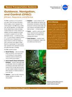
Guidance, Navigation, and Control (GN&C)
www.nasa.govNavigation — system architecture trade . studies, sensor selection and modeling, posi - tion/orientation determination software (filter) development, architecture trade studies, auto - matic rendezvous and docking (AR&D), and Batch estimation — all mission phases. • Control — algorithms, vehicle and control system requirements and ...