
Chapter 4 - Photogrammetry
GNSS Global Navigation Satellite System (See also the application of GPS in this document.) GPS Global Positioning System (In this document it refers generically to space satellite system positioning. See Chapter 3 for application of specific space satellite systems.) GSD Ground Sampling Distance Hz hertz (frequency per second)
Download Chapter 4 - Photogrammetry

Information
Domain:
Source:
Link to this page:
Documents from same domain
Basic Highway Plan Reading - index html
www.codot.govBasic Highway Plan Reading Inspector ... The Standard Specifications, ... standard design and construction practices which are utilized on all projects.
COLORADO DEPARTMENT OF TRANSPORTATION …
www.codot.govcolorado department of transportation staff bridge bridge rating ... – reinforced concrete structures ... 8-4 rating concrete bridges with unknown reinforcing ...
Rules of the Road* - CDOT
www.codot.govRules of the Road* Ride on the right Riding on the right doesn’t mean hugging the curb or edge of the road. It means riding as far right as practicable and
for Road and Bridge Construction - CDOT
www.codot.govi Colorado Department of Transportation Standard Specifications for Road and Bridge Construction 2011
Work Zone Safety and Mobility Rule - CDOT
www.codot.govPage 4 of 58 Traffic Control Plan (TCP) Construction phasing greatly affects the safety and mobility of work zone users. It is important that designers and construction engineers who …

STUDIES OF ENVIRONMENTAL EFFECTS OF MAGNESIUM …
www.codot.govEven very close to the roadway, the potential of magnesium chloride deicer to cause environmental damage is probably much smaller than that of other factors related to road use and maintenance, including pollution of highway surfaces by
Associated Press Style - CDOT
www.codot.govAssociated Press Style Quick Reference Guide To subscribe to The Associated Press Stylebook online, or to find out about purchasing hard copies of the book, start here. To find out about StyleGuard for Word, start here. For slide presentations of AP Style basics, go here.
15 Load and Resistance Factor Rating LRFR - index html
www.codot.govThe Notional Rating Load (NRL) and Lane Type Legal truck for spans greater than 200 feet as specified in the AASHTO Bridge Evaluation Manual shall be included in the posting analysis.
00 Introduction Final - CDOT
www.codot.govApril 1, 2011 Introduction Page 4 of 4 The HL-93 load rating for the Load and Resistance Factor Rating (LRFR) method is reported as a rating factor. All other ratings are reported as a rating ... Bridge Rating Manual (see AASHTO LRFD 4.6.3.1, modified here as …

COLORADO DEPARTMENT OF PUBLIC HEALTH AND …
www.codot.govColorado Department of Transportation Compliance Order on Consent Page 1 of 28 COLORADO DEPARTMENT OF PUBLIC HEALTH AND ENVIRONMENT WATER QUALITY CONTROL DIVISION
Related documents
A Course Material on SATELLITE COMMUNICATION
www.sasurieengg.comThe earth station should be in a position to control the satellite if it drifts from its orbit it is subjected to any kind of drag from the external forces. Applications Of Satellites: Weather Forecasting Radio and TV Broadcast Military Satellites Navigation Satellites Global Telephone Connecting Remote Area

RINEX - IGS
files.igs.orgmessage file)”, section 6.12 “Satellite health (GPS Navigation message file)” and section 6.13 “Transmission time of message (GPS Navigation message file) since this is explained in the GPS navigation file definition section. - Removed the RINEX 3.04 Section 7 “RINEX under Antispoofing (AS)”

NAVSTAR, the Global Positioning System: A Sampling of Its ...
history.nasa.govsatellite navigation system.Whether all those capabilities could be melded into a fully integrated Global navigation Satellite System (GnSS) remained a question without an immediate answer, but the military, civil, and commercial utility of GpS was
Advisory - Federal Aviation Administration
www.faa.govd. Global Navigation Satellite System (GNSS). A worldwide position and time determination system, which includes one or more satellite constellations, aircraft receivers, and system integrity monitoring. GNSS is augmented as necessary to support the required navigation performance for the actual phase of operation. e. Global Positioning System ...
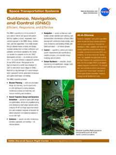
Guidance, Navigation, and Control (GN&C)
www.nasa.govGuidance, Navigation, and Control (GN&C) Efficient, Responsive, and Effective. At-A-Glance. Guidance, navigation, and control capabilities . will be needed for today’s launch and tomor - row’s in-space applications. Marshall has developed a GN&C capability with experience directly supporting projects and serving as

GLOBAL NAVIGATION SATTELITE SYSTEM GLONASS
www.unavco.orgThe purpose of the Global Navigation Satellite System GLONASS is to provide unlimited number of air, marine, and any other type of users with all-weather three-dimensional positioning, velocity measuring and timing anywhere in the world or near-earth space. 1.2 GLONASS components GLONASS includes three components:

ETREX 10/20/20X/30/30X Owner’s Manual - Garmin
www8.garmin.comAcquiring Satellite Signals. It may take 30 to 60 seconds to acquire satellite signals. 1 Go outdoors to an open area. 2 If necessary, turn on the device. 3 Wait while the device searches for satellites. flashes while the device determines your location. shows the satellite signal strength. Turning On the Backlight. Select any key to turn on ...

Owner’s Manual INSTINCT - Garmin
www8.garmin.comOwner’s Manual INSTINCT - Garmin ... 8