
ggmap: Spatial Visualization with ggplot2
While longitude/latitude pairs are ideal for specifying a location, they are somewhat inconvenient on a practical level. For this reason, location also accepts a character string. The string, whether containing an address, zip code, or proper name, is then passed to …
Download ggmap: Spatial Visualization with ggplot2

Information
Domain:
Source:
Link to this page:
Documents from same domain
rworldmap: A New R package for Mapping Global Data
journal.r-project.orgAwareness’ world map representing ’the intensity with which artist Bono is aware of the plight and daily struggles of region’, with a categorisation rang-
pdp: An R Package for Constructing Partial Dependence …
journal.r-project.orgWiener,2002) and gbm (Ridgeway,2017), among others; these are limited in the sense that they only apply to the models fit using the respective package. For example, the partialPlot function in randomForest only applies to objects of class "randomForest" and the plot function in gbm only applies to "gbm"objects.

Solving Differential Equations in R
journal.r-project.orgIntroduction Differential equations describe exchanges of matter, energy, information or any other quantities, often as ... • Stochastic differential equations (SDE), using packages sde (Iacus,2008) and pomp (King ... parabolic PDEs such as the heat equation, and to hy-perbolic PDEs such as the wave equation.

Nonparametric Tests for the Interaction in Two-way ...
journal.r-project.orgAlvo(2005) developed their own ranking method to test for the interaction in such designs, by comparing the sum of row ranks with the sum of column ranks. The interaction.test function from the StatMethRank package byQuinglong(2015) is an application of this method. The already mentioned nparLD package offers two functions for two-way designs ...
Related documents
NOTICE OF INTENT (NOI) For Coverage(s) of Primary ...
scdhec.govD. Impaired Waterbodies Information (Attach additional sheet(s) as needed) 1.303(d) Listed Impaired Waterbodies a. Name of Nearest DHEC Water Quality Monitoring Stations (WQMS)(s) that receives stormwater from your construction site and/or thru an MS4 and the Name of the Corresponding Waterbody?
APPLICATION FOR ENCROACHMENT PERMIT
transportation.ky.govLONGITUDE (X) LATITUDE (Y) ADDITIONAL LOCATION INFORMATION: FOR KYTC USE ONLY PERMIT TYPE: Air Right Entrance Utilities Vegetation Removal Other: ACCESS: Full Partial by Permit LOCATION: Left Right Crossing

Latitude and Longitude - Kettering City School District
www.ketteringschools.orgLongitude, Latitude, Longitude, Latitude, Yes, I know what Longitude, Latitude mean. Longitude is the angular distance measured in degrees. It tells how far from Greenwich England anyplace happens to be. East or West from Greenwich England, wherever a place may be, Longitude gives the angular distance, scientifically. Do you know what Longitude ...

Latitude, Longitude and Time - NCERT
www.ncert.nic.inLatitude, Longitude and T ime eastern and western hemispheres. In other words, the sun traverses 15 0 of longitudes per hour or one degree of longitude in every four minutes of time. It may further be noted that the time decr eases when we move fr om west to east and incr eases with our westwar d movement.
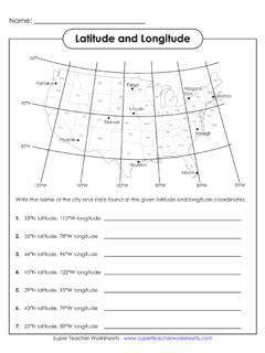
Latitude and Longitude - Super Teacher Worksheets
www.superteacherworksheets.comWrite the name of the city and state found at the given latitude and longitude coordinates. 1. 33°N latitude, 112°W longitude 2. 35°N latitude, 78°W longitude 3. 46°N latitude, 96°W longitude 4. 45°N latitude, 122°W longitude 5. 29°N latitude, 95°W longitude 6. 43°N latitude, 79°W longitude 7. 25°N latitude, 80°W longitude ANSWER KEY

4: Drainage (Below Ground Stormwater)
www.vba.vic.gov.auTable E1 lists latitude and longitude of selected places, some of which are marked on the maps. If there is any doubt regarding . Technical Solution Sheet 4.04 Updated December 2015 www.vba.vic.gov.au Page 4 of 6 the rainfall intensity for a particular area, refer to the relevant council / shire for ...