
INTRODUCTION: BASIC GEOGRAPHIC CONCEPTS
Projected coordinate systems portray the earth in a two-dimensional flat surface (paper or computer screen). To more accurately represent locations on the earth's surface, map makers studied the shape of the earth (geodesy) and created the concept of the spheroid. A datum links a spheroid to a particular portion of the earth's surface.
Download INTRODUCTION: BASIC GEOGRAPHIC CONCEPTS

Information
Domain:
Source:
Link to this page:
Documents from same domain

School of Economic Sciences - ses.wsu.edu
ses.wsu.eduacre, or $2,000 for a typical 1,000-acre farm) to farmers who plant 75-80% of their crops using Monsanto™s genetically modi–ed seeds. Importantly, these insurance discounts are not o⁄ered to farmers using genetically modi–ed seeds

Regional Economic Modeling - Washington State University
ses.wsu.eduRegional Economic Modeling I Methodology & tools yielding data-based predictions for a particular geographic or political area I Useful for simulating economic activity Outcomes from di erent policies Outcomes from shocks (good and bad) to region

2000 Carrot Enterprise Budgets Columbia Basin, Washington ...
ses.wsu.eduOverall, Washington ranks second to California in production of carrots. Washington produces approximately 33% of the processing carrots grown in the U.S. and 3% of the fresh carrots.
Explaining Total Factor Productivity Change in U.S ...
ses.wsu.edu1 Explaining Total Factor Productivity Change in U.S. Agriculture: An Examination of Components By Darlington Sabasi* and C. Richard Shumway Darlington Sabasi is a Ph.D. Graduate Research Assistant, and C. Richard Shumway is a Regents

Small Winery Investment and Operating Costs
ses.wsu.eduThe objective of this study is to develop an accurate depiction of current investment costs of constructing, owning, and operating a winery in the state of Washington. Potential investors and ... The equipment lists include equipment prices plus shipping and installation costs.
Related documents
Tennessee Academic Standards for Science
www.tn.govgrades K-12 will deepen content knowledge and build on learning. The progressions are designed to build on student understanding of science with developmental appropriateness. The science and engineering practices are integrated throughout the physical, life, and earth DCI groups shown below. PHYSICAL SCIENCES (PS) PS1: Matter and Its Interactions
500 - OCLC
www.oclc.orgchemistry and allied sciences, see 540; for earth sciences, see 550.5 Space sciences For astronomy, see 520; for earth sciences in other worlds, see 550. For space sciences aspects of a specific subject, see the subject, plus notation 091 from Table 1, e.g., chemical reactions in space 541.390919 See Manual at 520 vs. 500.5, 523.1, 530.1, 919.9

Pennsylvania Learning Standards for Early Childhood …
s35729.pcdn.co3 KEY LEARNING AREA: Social Studies Thinking – Connecting to Communities Standard Area 5.1: Civics and Government – Principles and Documents of Government . .68 Standard Area 5.2: Civics and Government – Rights and Responsibilities of Citizenship . .69 Standard Area 5.3: Civics and Government – How Government Works . .70 Standard Area 5.4: Civics and …
ASSESSMENT REQUIREMENTS FOR VIRGINIA LICENSURE
doe.virginia.govEarth and Space Sciences: Content Knowledge X (5571) computer 156 Earth Science ELEMENTARY EDUCATION: Elementary Subject Tests are required for initial licensure but CANNOT be used to add an Early/Primary preK-3 or Elementary Education preK …
Academic Standards for Science and Technology
www.stateboard.education.pa.govEarth Sciences 3.2. Inquiry and Design 3.6. Technology Education 3.3. Biological Sciences 3.7. Technological Devices 3.4. Physical Science, Chemistry 3.8. ... measuring, computing, estimating, communicating, using space/time relationships, defining operationally, raising questions, formulating hypotheses, testing and ... Knowledge of content ...

Pennsylvania Learning Standards for Early Childhood PRE ...
www.education.pa.govlearning strategies where children are engaged in concrete and hands- should be combined with child-initiated play to produce optimal con competencies, and thinking skills of science, technology, engineering,
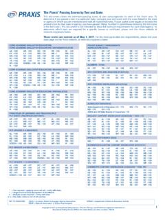
The Praxis Series ™ Passing Scores by Test and State
doe.nv.govearth and space sciences: content knowledge (0571/5571) AK - 144 AL - 150 AR - 145 CT - 157 DE - 150 HI - 147 IA - 149 ID - 144 KS - 150 KY - 147

SCIENCE STANDARDS
tea.texas.govKnowledge and Skills [TEKS]) in life science. Standard X. The science teacher knows and understands the science content appropriate to teach the statewide curriculum (Texas Essential Knowledge and Skills [TEKS]) in Earth and space science. Standard XI. The science teacher knows unifying concepts and processes that are common to all sciences.

K to 12 BASIC EDUCATION CURRICULUM SENIOR HIGH …
www.deped.gov.phK to 12 BASIC EDUCATION CURRICULUM SENIOR HIGH SCHOOL – ACADEMIC TRACK HUMANITIES AND SOCIAL SCIENCES K to 12 Senior High School Humanities and Social Sciences Strand – Disciplines and Ideas in the Social Sciences February 2014 Page 4 of 7 GLOSSARY1 Absolute location The exact position of an object or place stated in spatial …