
Python for ArcGIS - Writing Scripts to Manipulate …
Python for ArcGIS - Writing Scripts to Manipulate GIS Data 1-102-303 Map Documents – Manipulating the contents, layer properties, and other aspects of a map
Download Python for ArcGIS - Writing Scripts to Manipulate …

Information
Domain:
Source:
Link to this page:
Documents from same domain

GISP Test Prep Course - Teach Me GIS .com
www.teachmegis.comGISP Test Prep Course 1-900-101 KA5: Data Manipulation – Review of the data types and the considerations involved in data
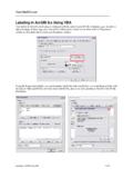
Labeling in ArcGIS using VBA - Teach Me GIS .com
www.teachmegis.comTeachMeGIS.com Labeling in ArcGIS using VBA 2 of 2 Below is a chart of some useful VBA constants and functions you may need when creating labels in

Expressions Simple - TeachMeGIS
www.teachmegis.com© 2011 TeachMeGIS All rights reserved. Revised 04/11 1 1 S.com ions 2 Presentation Overview Label Expressions Simple Expressions Functions Advanced Expressions

Fundamentals of ArcGIS for Petroleum - TeachMeGIS
www.teachmegis.comFundamentals of ArcGIS for Petroleum 2-102-100 Asking Questions of Your Data – Ask questions of your data, such as, “Where are the leases that

Field Data Collection with Collector and Survey123
www.teachmegis.comField Data Collection with Collector and Survey123 1-103-109 Field Data Collection with Collector and Survey123 Course Length: 1 day ArcGIS Version: 10.x

Function Calculations Simple Calculations - …
www.teachmegis.com© 2012 TeachMeGIS All rights reserved. Revised 05/12 2 3 t? r 4 Field Calculator Use the Field Calculator to modify records in a table
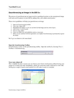
Georeferencing an Image in ArcGIS - Teach Me GIS …
www.teachmegis.comTeachMeGIS.com Georeferencing an Image in ArcGIS 9.x 2 of 3 Manipulate the display so you can see both layers In order to pick your control points, you need to be able to see both your good data and your data
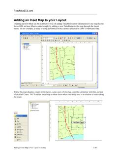
Adding an Inset Map to your Layout - Teach Me …
www.teachmegis.comTeachMeGIS.com Adding an Inset Map to Your Layout in ArcMap 1 of 4 Adding an Inset Map to your Layout Utilizing an Inset Map can be an effective way of adding valuable location information to any map layout.

GIS Tips and Tricks - Teach Me GIS .com
www.teachmegis.com1-2 Chapter Overview ArcGIS Desktop –New tools in ArcGIS 10 that are really cool –Some “oldies but goodies” you might not have seen (or don’t remember that you’ve seen) A little aside into Excel….

Using Reports as a Quick Reference to Map Books
www.teachmegis.comGIS Tips & Tricks 2 March 2014 2: Add a Name field to the grid’s attribute table and then use the Field Calculator to populate the values. HINT: For quick numbering, populate the values using the OID field. NOTE: Though it is generally discouraged to use the OID field for anything, in this case
Related documents

ArcGIS 10 System Requirements - Virginia Tech
gep.frec.vt.eduArcGIS 10 System Requirements - 2 If using ArcGlobe (as part of 3D Analyst), additional disk space may be required. ArcGlobe will create cache files when used.

Adding ArcGIS server services to ArcMap - Kentucky
kygeonet.ky.govAdd ArcGIS Server This Wizard guides you through the process of making a connection to an ArcGIS Server. You can create a connection to use, publish, or administer

ArcGIS 10.4 for Server Functionality Matrix - Esri
www.esri.com1 ArcGIS 10.4 for Server Functionality Matrix Introduction Web GIS is a pattern for delivering GIS capabilities and is at the center of Esri’s

A (very basic) Introduction to GIS using ArcGIS
www.nyu.eduAgenda What is GIS? Basic GIS Concepts Introduction to ArcGIS Coordinates & Projections GIS Analysis Thematic maps Exporting GIS data/analysis to a dataset Back and forth between GIS concepts and ArcGIS
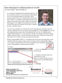
project Coordinate Systems in ArcGIS - RS Geospatial
www.resourcesupplyllc.com(Copyright 2014 by Resource Supply, LLC) 1 How to Re Resource Supply, LLC 11607 SW Winter Lake Drive
Labeling in ArcGIS using VBA - Teach Me GIS .com
www.teachmegis.comTeachMeGIS.com Labeling in ArcGIS using VBA 2 of 2 Below is a chart of some useful VBA constants and functions you may need when creating labels in