Transcription of 17497 - Main Loop Map Update 1 WEB - webcms.pima.gov
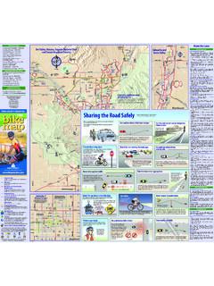
1 CMO. DE OESTEALVERNONDODGECAMPBELLMOUNTAINFIRSTS TONECOUNTRY CLUBC hildren sMemorial ParkRillito RegionalPark andRillito RacetrackDan FelixMemorial ParkKory Laos MemorialFreestyle BMX ParkSun CircleRio Vista ParkORACLETUCSONR iver Parkexpansion currently denied at Tucson Mall s CA ADAORACLEFIRSTLA CHOLLASHANNONINAORANGE GROVECORTARO FARMSCAMINO DE LA TIERRAC hristina-TaylorGreen MemorialRiver ParkLA CA ADATHORNYDALETHORNYDALESHANNONLAMBERTOVE RTONHARDYMAGEELA CHOLLATANGERINEFIRSTNARANJA CoronadoNationalForestCatalinaStateParkC a ada del OroRiverfront ParkSteam PumpRanchORO VALLEYTANGERINETANGERINETWIN PEAKSAVRA VALLEYLINDA VISTAHARTMANWADECAMINO DE OESTEEL CMO. DE MA ANAS anta Cruz River Santa Cruz River ParkGladden FarmsNeighborhoodParkEl RioPreserveWadeMcLeanParkMaranaHeritageP arkCrossroadsat SilverbellDistrict ParkMike JacobSports ParkTed WalkerParkChristopher Columbus ParkSilverbellGolf CourseCORTAROSILVERBELLEL CAMINO DEL CERROSANDERSSANDAROCAMINO DE OESTESUNSETSUNSETSWEETWATERGORETIRONWOOD HILLSMARANAG eorge MehlFamily FoothillsParkSweetwaterWetlandsSantaCruz ParkJuhan ParkSPEEDWAYPIMACRAYCROFTSAHUARASWANCOLU MBUST anque Verde CreekFort LowellParkRIVERTANQUE VERDEPANTANOBEAR CANYONHARRISONHARRISONSABINO CANYONCLOUDC oronadoNationalForestSabino Canyon NationalRecreation AreaHOUGHTONSNYDERPRINCEFT.
2 LOWELLCATALINA HWYSUNRISESUNRISES entinelPeak ParkMILE WIDEKINNEYSTARR PASSGATES PASSANKLAMGREASEWOODBROADWAY6TH5 THGLENNJ ulian WashArchaeologicalParkAJOMISSIONKino EnvironmentalRestoration ProjectKINO29TH29TH29TH29TH22 NDSOUTHTUCSONGOLF LINKSKOLBWILMOTKino SportsComplexWillie BlakeParkHARRISONCAMINO SECOESCALANTEHOUGHTONFREEMANCAMINO SECOCENTREPARKKENYONESCALANTEPANTANOPRUD ENCES aguaroNationalParkOLD SPANISH TRAILP aseode lasIglesiasSam LenaPark Ca ada del Oro River ParkGRANTGLENNFT. LOWELLPRINCEMIRACLEMILESKYLINEINACAMPBEL LCRAYCROFTKOLBSOLDIER TRAILORACLESELLAROLESILVERBELLST. MARY SSANDARIOTWIN PEAKSSILVERBELLMOOREMOORETWIN PEAKSCONGRESSTUCSONRANCHO VISTOSOM orris K. UdallRegional CenterTANQUE VERDE Pantano River ParkCALLE CONCORDIAPUSCHVIEW FentonMemorial ParkRUTHRAUFFWETMORESPEEDWAY SABINO CANYONPICTURE ROCKSINNOVATION ParkSKYLINEU niversityof ParkFlowingWells ParkVerdugoPark4 THSanta Cruz River ParkRillito River ParkAVIATION YMCAPima CountyCommunity CenterAnn DayCommunity ParkTumamocHillMissionGardensLoop Guidelines Hours: dawn to dusk Treat all trail users with respect and courtesy.
3 Maintain awareness of other trail users. Bicyclists control your speed and be prepared to slow or stop as conditions dictate. Stay on the right and pass on the left. Do not cross into oncoming tra c. Call out Passing! or ring a bell when overtaking another user. Pedestrians should watch and listen for cyclists and provide space on the path for them to pass safely. Don t suddenly stop or change direction on the path. Keep pets leashed and under control at all times. No motorized vehicles or devices allowed. (ADA accessibility and o cial vehicles exempt). Trail conditions subject to change. Verify trail conditions prior to use. Use trail at your own risk. Organized special uses on The Loop require prior permission. For a complete list of Loop guidelines, please visit 2021 Interactive map available online County Board of SupervisorsSharon Bronson, Chair, District 3 Adelita S.
4 Grijalva, Vice Chair, District 5 Rex Scott, District 1Dr. Matt Heinz, District 2 Steve Christy, District 4 Pima County AdministratorChuck HuckelberryThe Chuck Huckelberry Loopis a system of paved, shared-use paths and short segments of bikelanes connecting the Rillito, Santa Cruz, Pantano and Ca ada delOro River Parks with the Julian Wash and Harrison Road includes both sides of the river park as well as neigborhood pathconnectors. The Loop extends through unincorporated Pima County, Marana, Oro Valley, Tucson, and South Tucson. PATHWAY SYSTEM MAPO nline resources at : Safety on the Loop Notices and Closures Additional maps, including Interactive Map, Art on the Loop Map, Downtown Art Map, and Tucson Metro Bike Map On Facebook @ / CommentsRegional Flood Control District, 520-724-4600 Natural Resources, Parks and Recreation Department, 520-724-5000or information on this map is subject to change and its accuracy cannot be County makes no representation or warranties, expressed or implied, as to accuracy, completeness, timeliness, or rights to the use of such information.
5 The Loop Shared-use PathClosureUnder DevelopmentFuture segmentsParkingBathroomWaterJuan Bautista de Anza historic Trail2 Scale in Park Distances Main Loop: Santa Cruz River Park, Rillito River Park, Pantano River Park,Harrison Greenway, and Julian Wash Greenway, as a complete circle .. miles Rillito River Park from Santa Cruz to Craycroft Road (Pantano River Park).. miles Santa Cruz River Park from Valencia Road to Avra Valley Road .. miles Pantano River Park from Harrison Greenway to Rillito River Park .. miles Harrison Greenway, Julian Wash Greenway to Sellarole Street .. miles(including use of both the pathway and green highlighted on-street connector) Julian Wash Greenway, Santa Cruz River Park to Harrison Greenway .. miles Ca ada del Oro River Park, Santa Cruz River Park to Tangerine milesPuerto del AzotadoTrailheadCatalina State Park to Biosphere 2.
6 See inset on YMCAPima CountyCommunity CenterAnn DayCommunity ParkALVERNONDODGECAMPBELLMOUNTAINFIRSTST ONECOUNTRY CLUBC hildren sMemorial ParkRillito RegionalPark andRillito RacetrackDan FelixMemorial ParkKory Laos MemorialFreestyle BMX ParkSun CircleRio Vista ParkORACLETUCSONR iver Parkexpansion currently denied at Tucson Mall s CA ADAORACLEFIRSTLA CHOLLASHANNONINAORANGE GROVECORTARO FARMSCAMINO DE LA TIERRAC hristina-TaylorGreen MemorialRiver ParkTHORNYDALESHANNONOVERTONHARDYMAGEELA CHOLLAC oronadoNationalForestLINDA VISTAHARTMANWADE Santa Cruz River ParkEl RioParkWadeMcLeanParkCrossroadsat SilverbellDistrict ParkMike JacobSports ParkTed WalkerParkChristopher Columbus ParkSilverbellGolf CourseCORTAROSILVERBELLEL CAMINO DEL CERROSANDAROCAMINO DE OESTESUNSETSUNSETSWEETWATERGORETIRONWOOD HILLSG eorge MehlFamily FoothillsParkSweetwaterWetlandsSantaCruz ParkJuhan ParkSPEEDWAYPIMACRAYCROFTSAHUARASWANCOLU MBUST anque Verde CreekFort LowellParkRIVERTANQUE VERDEPANTANOBEAR CANYONHARRISONHARRISONSABINO CANYONCLOUDC oronadoNationalForestSabino Canyon NationalRecreation AreaHOUGHTONSNYDERPRINCEFT.
7 LOWELLCATALINA HWYSUNRISESUNRISES entinelPeak ParkMILE WIDEKINNEYSTARR PASSMIDVALE PARKCARDINALMARKCAMINO VERDEGATES PASSANKLAMGREASEWOODVALENCIABROADWAY6TH5 THGLENNJ ulian WashArchaeologicalParkAugie Acu aLos Ni osParkAJOIRVINGTONDREXELCAMPBELLPARKTUCS ONCOUNTRY CLUBPALO VERDE12 THJOSEPHMISSIONBENSON LINKSKOLBWILMOTCRAYCROFTWILMOTKino SportsComplexWillie BlakeParkJulian WashJulian WashFantasy IslandMountain BikeTrails ParkIRVINGTONHARRISONCAMINO SECOESCALANTEOLD VAILVALENCIAHOUGHTONFREEMANCAMINO SECOCENTREPARKKENYONESCALANTEPANTANOPRUD ENCEKOLBS aguaroNationalParkOLD SPANISH TRAILP aseode lasIglesiasPaseode lasArbolesSam LenaParkThomas JayRegional Park Ca ada del Oro River ParkGRANTGLENNFT. LOWELLPRINCEMIRACLEMILESKYLINEINACAMPBEL LCRAYCROFTKOLBSOLDIER TRAILSELLAROLESILVERBELLST.
8 MARY STWIN PEAKSCONGRESSTUCSONM orris K. UdallRegional CenterTANQUE VERDENEXUS RITA Pantano River ParkCALLE CONCORDIAB randi FentonMemorial ParkRUTHRAUFFWETMORESPEEDWAY SABINO CANYONPICTURE ROCKSRoySchoonoverTrailheadMichaelPerry ParkSKYLINEU niversityof ParkFlowingWells ParkHarrison GreenwayVerdugoPark4 THIron HorseParkSanta Cruz River ParkRillito River ParkKino EnvironmentalRestoration Project10480 100819 DBCMO. DE OESTEEL CAMINO DEL CERROS anta Cruz River ParkSabino CanyonNationalRecreation AreaScale in expansions to the Chuck Huckelberry LoopThe Pima County Regional Flood Control District and Natural Resources, Parks and Recreation Department are developing a master plan that includes conceptual alignments of extensions of the Loop to fully integrate the shared-use path as an active recreational element in the urban area.
9 Specific plans for extending the Loop are under development for the following segments:1. Cienega Creek / Vail: Along the Pantano Wash from the present end of the Loop to the Cienega Creek Natural Preserve;2. Catalina State Park / Biosphere II: Through Catalina State Park, then north, generally along the Ca ada de Oro Wash past the Pima County line toward Miraval Arizona Resort and Spa and Biosphere II;3. Canoa Ranch: Along the Santa Cruz River south of Valencia Road to Green Valley and historic Canoa Verde Creek: (shown on full map), along the north bank from Craycroft Road to Tanque Verde Road with access to Sabino Canyon National Recreation Loop Shared-use PathClosureUnder DevelopmentFuture segmentsParkingBathroomWaterJuan Bautista de Anza historic Trail132 Pantano Wash to Cienega Creek / VailSanta CruzRiver toCanoa RanchOLD VAILOLD SPANISH TRAILLAGO DEL OROOLD SPANISH TRAILJ ulian WashIRVINGTONHARRISONH arrison GreenwayESCALANTEVALENCIAHOUGHTONWENTWOR THLOMA ALTAEDWIN WashVALENCIA CA ADAOLD NOGALES MINE PimaCounty FairgroundsCatalinaState ParkOracleJunctionSaddlebrookCienegaCree kPreserveGreenValleyCanoaRanchBiosphere llRANCHO VISTOSOHWY.
10 77 HWY. 79 OLD NOGALES Park toBiosphere 2 MARY ANN CLEVELANDSADDLEBROOKE Houghton Road, see Cruz River to Canoa Ranch, see to you by REACH: Pima County Health Department s Racial and Ethnic Approaches to Community Health Program.