Transcription of 2019 Wildfire Activity Statistics - Welcome to CAL FIRE
1 2019 . Wildfire Activity Statistics Thomas W. Porter Director california Department of forestry and fire protection Wade Crowfoot Secretary Natural Resources Agency Gavin Newsom Governor State of california 2019 Wildfire Activity Statistics california Department of forestry and fire protection 2019 Wildfire Activity Statistics california Department of forestry and fire protection Office of the State fire Marshal Administration/Executive Office Mailing Address: Box 944246 Sacramento, CA 94244-2460. Location Address: 2251 Harvard Street, Suite 400, Sacramento, CA 95815. Phone: (916) 568-2928. california Incident Data and Statistics Program (CalStats).
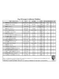
2 Phone: (916) 568-2926. Acknowledgements We wish to acknowledge and thank all who supplied data, resources, professional expertise, and assisted in the review of the reports. i 2019 Wildfire Activity Statistics california Department of forestry and fire protection Table of Contents Foreword Wildfire Activity Statistics iii-iv 2019 Statewide fire Summary Table 1. protection Areas by Wildfire Agency Fires and Acres 1. Table 2. The Top Five Fires by Acreage Burned 1. AREA PROTECTED. Map 1. State Responsibility Area (SRA) 2. Table 3. State Responsibility Area, Acres Protected by State and Other Agencies 3-4. Map 2.
3 CAL fire Direct protection Area (DPA) 5. Table 4. CAL fire Direct protection Area, Acres Protected by Jurisdiction 6-7. Wildfire Statistics california Wildfire AGENCIES. Table 5. Large Fires 300 Acres and Greater State and Contract Counties Direct 8-9. protection Area Table 6. Large Fires 300 Acres and Greater Other Agencies Direct protection Area 10-11. Table 7. Number of Fires and Acres Burned by Cause and by Size in Contract Counties 12-13. Wildfire Statistics CAL fire . Fires Table 8. Number of Fires by Cause, by Unit 14. Table 9. Number of Fires by Cause, by County 15-16. Table 10. Number of Fires and Acres Burned by Cause Detailed 17-19.
4 Table 11. Number of Fires by Size, by Unit 20. Table 12. Number of Fires by Size, by County 21-22. Acres Burned Table 13. Number of Acres Burned by Cause, by Unit 23. Table 14. Number of Acres Burned by Cause, by County 24-25. Table 15. Number of Acres Burned by Vegetation Type, by Unit 26. Table 16. Number of Acres Burned by Vegetation Type, by County 27-28. Dollar Damage Table 17. Dollar Damage by Cause, by Unit 29. Table 18. Dollar Damage by Cause, by County 30-31. Table 19. Dollar Damage by Size, by Unit 32. Table 20. Dollar Damage by Size, by County 33-34. fire Activity Statewide Graphic Figure 1. Percent of Fires by Cause 35.
5 Graphic Figure 2. Number of Acres Burned 2010- 2019 36. Graphic Figure 3. Number of Fires 2010- 2019 37. Graphic Figure 4. Number of Fires by Cause 2019 , 2018 and 5 Year Average 38. Graphic Figure 5. Fires and Acres 2019 , 2018 and 5 Year Average 39. Graphic Figure 6. Fires and Acres by Region 2019 , 2018 and 5 Year Average 40. Graphic Figure 7. Arson Fires and Acres 2010- 2019 41. Graphic Figure 8. Number of Fires by Time of the Day 42. Graphic Figure 9. Number of Fires and Acres Burned by Month 43. Graphic Figure 10. Structures Destroyed 1999- 2019 44. Glossary 45-46. ii 2019 Wildfire Activity Statistics california Department of forestry and fire protection FOREWORD.
6 Wildfire Activity Statistics . The california Department of forestry and fire protection (CAL fire ), under the direction of the State Board of forestry and fire protection , provides the annual Wildfire Activity Statistics report. Although it contains other information, this report is primarily a statistical record of Wildfire incidents responded to by CAL fire personnel and resources, performing the State/CAL fire mission, using State funding within CAL fire Direct protection Area (DPA). The existing overall fire protection system involving CAL fire and california as a whole is rather complex. A number of technical terms are utilized and the use of fire Statistics typically presupposes some understanding of the overall framework.
7 A description of this framework can be found at ( ); and in the Glossary of terms at the end of this document. The first Forest fire Summary (RED BOOK) was published in 1943, and has continued to this date. Prior to 1989, data and Statistics were tabulated manually; today, Statistics are derived from an automated database. CAL fire began electronically entering incident data into the Emergency Activity Reporting System (EARS) on July 1, 1989. Starting at the end of 2006, CAL fire began reporting incidents using a web-based subscription service called california All Incident Reporting System (CAIRS). In 2019 , CAL fire began reporting incidents using a web-based subscription service called CAL fire Incident Reporting System (CALFIRS).
8 This data is imported into the california Incident Data and Statistics (CalStats) database by CAL fire staff and the data is uploaded annually to the National Database maintained by the United States fire Administration (USFA). Due to the changes in data collection, methods, and systems over the years, information may not always be comparable and data may be of differing accuracy or completeness. Throughout this report, the Statistics are displayed by who provides the Wildfire protection . Forces include CAL fire personnel and resources, CAL fire employees working under a local government agreement, Contract County personnel, and federal firefighting resources.
9 The second part of the statistical reporting is where the protection is provided. Areas are categorized as State Responsibility Area (SRA) or DPA. SRA is State and privately-owned forest, watershed, and rangeland for which the primary financial responsibility of preventing and suppressing wildfires rests with the State (Map 1). The term Direct protection Area is applied to indicate when a particular fire protection organization has the primary responsibility for responding to an uncontrolled fire and for directing the suppression Activity . Thus, in addition to lands in SRA, CAL fire may have direct protection responsibility on lands in federal jurisdiction.
10 At the same time, federal agencies, such as the Forest Service, may have direct protection responsibility for lands in SRA. The lands in SRA and federal areas for which CAL fire has direct protection responsibility for fire protection responses are depicted on Map 2. The State contracts with six counties to provide protection of SRA within their boundaries. These counties [Kern, Los Angeles, Marin, Orange, Santa Barbara, and Ventura] are referred to as Contract Counties. iii 2019 Wildfire Activity Statistics california Department of forestry and fire protection CAL fire provides fire protection services to many california citizens through the administration of 150 cooperative fire protection agreements in cities, districts, and 36 of the State's 58 counties.
![CHAPTER 7A [SFM] MATERIALS AND CONSTRUCTION METHODS FOR ...](/cache/preview/4/b/b/0/4/f/9/9/thumb-4bb04f99e9c7f2d3944506316495658b.jpg)