Transcription of 3 Geodesy, Datums, Map Projec- tions, and Coordinate Systems
1 853 Geodesy, Datums, Map Projec- tions, and Coordinate SystemsIntroductionGeographic information Systems are different from other information Systems because they contain spatial data. These spatial data include coordinates that define the location, shape, and extent of geo-graphic objects. To effectively use GIS, we must develop a clear understanding of how Coordinate Systems are established for the Earth, how these coordinates are measured on the Earth s curving surface, and how these coordinates are converted for use in flat maps, either digital or paper. This chap-ter introduces geodesy, the science of mea-suring the shape of the Earth, and map projections, the transformation of coordi-nate locations from the Earth s curved sur-face onto flat maps. Defining coordinates for the Earth s surface is complicated by three main fac-tors.
2 First, most people best understand geography in a Cartesian Coordinate system on a flat surface. Humans naturally per-ceive the Earth s surface as flat, because at human scales the Earth s curvature is barely perceptible. Humans have been using flat maps for more than 40 centuries, and although globes are quite useful for visualization at extremely small scales, they are not practical for most purposes. A flat map must distort geometry in some way because the Earth is curved. When we plot latitude and longitude coor-dinates on a Cartesian system , straight lines will appear bent, and polygons will be distorted. This distortion may be difficult to detect on detailed maps that cover a small area, but the distortion is quite apparent on large-area maps. Because measurements on maps are affected by the distortion, we must use a map projection to reconcile the portrayal of the Earth s curved surface onto a flat second main problem in defining a Coordinate system results from the irregular shape of the Earth.
3 We learn early on that the Earth is shaped as a sphere. This is a valid approximation for many uses, how-ever, it is only an approximation. Past and present natural forces yield an irregularly shaped Earth. These deformations affect how we best map the surface of the Earth, and how we define Cartesian Coordinate Systems for mapping and , our measurements are rarely perfect, and this applies when measuring both the shape of the Earth, and the exact position of features on it. All locations depend on measurements that contain some error, and on analyses that require assump-tions. Our measurements improve through time, and so does the sophistication of our analysis, so our positional estimates improve; this evolution means our esti-mates of positions change through of these three factors, we often have several different sets of coordi-nates to define the same location on the sur-face of the Earth.
4 Remember, coordinates 86 GIS Fundamentalsare sets of numbers that unambiguously define locations. They are usually x and y values, or perhaps x, y, and z values, or lati-tude and longitude values unique to a loca-tion. But these values are only unique to the location for a specified set of measure-ments and time. The coordinates depend on how we translate points from a curved Earth to a flat map surface (first factor, above), the estimate we use for the real shape of the Earth (second factor), and what set of mea-surements we reference our coordinates to (the third factor). We may, and often do, address these three factors in a number of different ways, and the coordinates for the same point will be different for these differ-ent choices. An example may help.
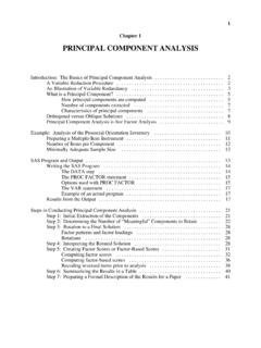
5 Figure 3-1 shows the location of a benchmark, a precisely surveyed and monumented point. Coordi-nates for this point are maintained by federal and state government surveyors, and result-ing coordinates shown at the top right of the figure. Note that there are three different ver-sions of the latitude/longitude location for this point. In this case, the three versions dif-fer primarily due to differences in the mea-surements used to establish the point s location, and how measurement errors were adjusted (the third factor, discussed above). The GIS practitioner may well ask, which latitude/longitude pair should I use? This chapter contains the information that should allow you to choose that there are also several versions of the x and y coordinates for the point in Figure 3-1.
6 The differences in the Coordinate values are too great to be due solely to mea-surement errors. They are due primarily to how we choose to project from the curved Earth to a flat map (the first factor), and in part to the Earth shape we adopt and the measurement system we use (the second and third factors). We first must define a specific coordi-nate system , meaning we choose a specific way to address the three main factors of pro-jection distortion, an irregularly shaped Earth, and measurement imprecision. There-after the coordinates for a given point are Coast and Geodetic Survey Bench markNAD83(2007) 44 57 093 05 (1986) 44 57 093 05 (1996) 44 57 093 05 MNS 317, 871, MTSPC MNS 1,042, 2,857, sFTUTM15 4,978, 492, MTLatitude (N) Longitude (W)MN-Ramsey 573, 160, sFTMN-Ramsey 174, 48, MTSPC MNC 890, 95, MTSPC MNC 2,922, 314, sFTLCC 542, 18, MTX YX YFrom Surveyor Data:From Data Layers: coordinates for a Point LocationFigure 3-1: An example of different Coordinate values for the same point.
7 We may look up the coordinates for a well-surveyed point, and we may also obtain the coordinates for the same point from a number of dif-ferent data layers. We often find multiple latitude/longitude values (surveyor data, top), or x and y values for the same point (surveyor data, or from data layers, bottom). Chapter 3: Geodesy, Projections, and Coordinate Systems87fixed, as are the spatial relationships to other measured points. But it is crucial to realize that different ways of addressing 1) the Earth s curvature, 2) the Earth s deviation from our idealized shape, and 3) inevitable inaccuracies in measurement, will result in different Coordinate Systems , and these dif-ferences are the root of much confusion and many errors in spatial analysis. As a rule, you should understand the Coordinate system used for all of your data, and convert all data to the same Coordinate system prior to analy-sis.
8 The remainder of this chapter describes how we define, measure, and convert among Coordinate Measurements In specifying a Coordinate system , we must first define the size and shape of the Earth. Humans have long speculated on this. Babylonians believed the Earth was a flat disk floating in an endless ocean, while the Greek Pythagoras, and later Aristotle, rea-soned that the Earth must be a sphere. He observed that ships disappeared over the horizon, the moon appeared to be a sphere, and that the stars moved in circular patterns, all observations consistent with a spherical Earth. The Greeks next turned toward estimat-ing the size of the sphere. The early Greeks measured locations on the Earth s surface relative to the Sun or stars, reasoning they provided a stable reference frame.
9 This assumption underlies most geodetic observa-tions taken over the past 2000 years, and still applies today, with suitable refinements. Eratosthenes, a Greek scholar in Egypt, performed one of the earliest well-founded measurements of the Earth s circumference. He noticed that on the summer solstice the sun at noon shone to the bottom of a deep well in Syene, near Tropic of Cancer, so that the sun would be exactly overhead during the summer solstice. He also observed that 805 km north in Alexandria, at exactly the same date and time, a vertical post cast a shadow. The shadow/post combination defined an angle that was about 7o12 , or about 1/50th of a circle (Figure 3-2).Eratosthenes deduced that the Earth must be 805 multiplied by 50, or about 40,250 kilometers in circumference.
10 His cal-culations were all in stadia, the unit of mea-sure of the time, and have been converted here to the metric equivalent, using our best idea of a stadia length. Eratosthenes s esti-mate differs from our modern measurements of the Earth s circumference by less than 4%. Posidonius, another Greek scholar, made an independent estimate of the size of the Earth by measuring angles from local Figure 3-2: Measurements made by Eratosthenes to determine the circumfer-ence of the Fundamentalsvertical (plumb) lines to a star near the hori-zon (Figure 3-3). Stars visible in the night sky define a uniform reference. The angle between a plumb line and a star location is called a zenith angle. The zenith angle can be measured simultaneously at two locations on Earth, and the difference between the two zenith angles can be used to calculate the cir-cumference of the Earth.