Transcription of 30.36 Zoning Districts and Maps 1 30.36.010 Establishment ...
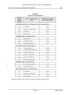
1 Zoning Districts and Establishment of Zoning Districts ..1. Interpretation of district Sequence..2. The Official Zoning Disclosure Maps..2. Custody of the Official Zoning Map..2. Amendments to the Official Zoning Map ..3. Rules for Interpretation of district Boundaries..3. Miscellaneous Maps..3. Printed Chapter : Zoning Districts and Maps Zoning Districts and Maps Establishment of Zoning Districts . In order to classify, regulate, and segregate the use of land, buildings and structures, and to regulate and restrict the height and bulk of buildings, the unincorporated territory of Clark County is divided into Districts as follows. 1. Residential Districts . A. Single Family Districts : i. Rural Residential: R-U, rural open land district R-A, residential agricultural district R-E, rural estates residential district R-D, suburban estates residential district ii. Suburban Residential: R-1, single-family residential district R-T, manufactured home residential district iii.
2 Compact Residential: R-2, medium density residential district RUD, residential urban density B. Multiple Family Residential Districts : R-3, multiple-family residential district R-4, multiple-family residential district (high density). R-5, apartment residential district 2. Commercial Districts . CRT, commercial residential transitional district C-P, office and professional district C-1, local business district C-2, general commercial district 3. Manufacturing Districts . M-D, designed manufacturing district M-1, light manufacturing district M-2, industrial district 4. Special Districts . O-S, open space district H-2, general highway frontage district P-F, public facility district R-V-P, recreational vehicle park district U-V, urban village district H-1, limited resort and apartment district Printed Chapter : Zoning Districts and Maps February 4, 2013. - 1. 5. Overlay Districts . Adult Use Overlay district Airport Airspace Overlay district Airport Environs (AE) Overlay district Asian Design Overlay district Cooperative Management Agreement (CMA) Area Design Overlay district Gaming Enterprise district Historic Neighborhood Overlay district Mixed Use Overlay district (MUD).
3 Moapa Valley Overlay district Red Rock Design Overlay district Residential Neighborhood Preservation (RNP) Overlay district South of Sahara Avenue (SOSA) Design Overlay district Spring Mountain Overlay district Transition Corridor Overlay district (Ord. 4016 1 (part), 4/2012; Ord 3955 4 (part), 6/2011; Ord. 3804 4. (part), 9/2009; Ord 3720 4 (part), 12/2008; Ord. 3521 2 (part), 6/2007; Ord. 3882 2 (part), 5/2006; Ord. 3174 3. (part), 1/2005; Ord. 3061 4 (part), 5/2004). Interpretation of district Sequence. a. Within the residential, commercial and manufacturing district categories, each district shall be deemed to be less restrictive than the district preceding it and each category shall be deemed to be less restrictive than the category preceding it. b. The overlay Districts shall provide additional requirements and limitations beyond those required by the underlying Zoning district only.
4 C. The regulations set by this Title within each district shall be considered minimum requirements and shall apply uniformly to each class or kind of structure or land, except as otherwise provided. (Ord. 4077 7, 2/2013). The Official Zoning Map. The County is divided into zones or Districts , as shown on the Official Zoning Map, which may be in the form as described in Section , including all explanatory matter, is adopted by reference and declared to be a part of this Title. Any map printed identifying the Official Zoning Map shall be identified by the following words: THIS IS THE OFFICIAL Zoning MAP REFERRED TO IN SECTION OF THE CLARK COUNTY. CODE OF THE COUNTY OF CLARK, STATE OF NEVADA AS OF _____ (Date).. Disclosure Maps. Per Section of the Clark County Code, the posting of Zoning maps and land use plan maps shall be required to be posted showing a 1 mile radius of the property for any residential subdivision with 10 or more lots.
5 The maps must be displayed within the sales office of the subdivision. Chapter of the Nevada Revised Statutes requires that at the time of the initial sale of land that the Zoning designation and master plan be disclosed to the buyer, and a copy of the Gaming Enterprise district Map is required to be provided with the location of the nearest Gaming Enterprise district . This information and maps for purchase are available in the offices of the Department of Comprehensive Planning and are also available, without charge, on the internet at within County Services by Department/Comprehensive Planning/Open Web Info Mapper selections. (Ord. 3229 6, 6/2005). Custody of the Official Zoning Map. Regardless of the existence of copies which may from time to time be made or published, the Official Zoning Map shall be under the custody of the County Clerk and maintained in an electronic database reflecting ordinances adopted to reclassify property.
6 This Official Zoning Map, so stored, shall be the final authority as to the current Zoning status of land and water areas, buildings, and other structures in the County. Printed Chapter : Zoning Districts and Maps February 4, 2013. - 2. Amendments to the Official Zoning Map No changes of any nature shall be made to the Official Zoning Map except in conformity with the procedures for amending the map as set forth in this Title. If changes are made to district boundaries or other matters portrayed on the Official Zoning Map, such changes shall be entered promptly after the ordinance to amend the district boundary adopted by the Board. No amendment to this Title which involves matters portrayed on the Official Zoning Map shall become effective until after such change has been adopted by the Board. Rules for Interpretation of district Boundaries. Where uncertainty exists as to the boundaries of Districts as shown on the Official Zoning Map, the approximate alignment of the boundary, indicated as follows, shall rule.
7 1. district boundary lines shall be construed to follow: A. The centerlines of streets, highways or alleys. B. Platted lot lines, section lines, quarter section lines or city limits. C. Railroad lines midway between the main tracks. D. Shorelines and, in the event of change in the shoreline, shall be construed as moving with the actual shoreline. Boundaries indicated as approximately following the centerlines of streams, rivers, canals, lakes or other bodies of water shall be constructed to follow such centerlines. 2. district boundaries indicated as parallel to, or extensions of, features indicated in subsection (1) of this Section shall be so construed. Distances not specifically indicated on the Official Zoning Map shall be determined by the scale of the map, or where an ordinance exists based on the legal description. 3. Where physical or cultural features existing on the ground do not coincide with those shown on the Official Zoning Map or are not covered by subsections (1) and (2) of this Section, the Zoning Administrator shall interpret the district boundaries.
8 Miscellaneous Maps. Maps and the electronic database creating such maps, are hereby adopted to describe specific geographic areas related to topography, air quality, airport functions, overlay Districts , community Districts , and the protection of rural areas. The maps are as adopted by the Board, and as amended by future action. These maps are shown in reduced form in Appendix G, and detailed copies are available for review and/or purchase from the Department of Comprehensive Planning. The maps are the basis of specific regulations listed within this title which are designed to mitigate the impact of development within the particular areas described. The maps are as follows: 1. Airport Airspace Maps. The maps described in Chapter and Part B of Chapter within which the height of structures is limited within airspace affected by aircraft operations. A. McCarran Airport Airspace Map B. Nellis AFB Airspace Map C.
9 North Las Vegas Airport Airspace Map D. (save for future Airport use). E. Jean Airport Airspace Map F. Overton Airport Airspace Map 2. DELETED. Printed Chapter : Zoning Districts and Maps March 23, 2015. - 3. 3. Community district Map. The community Districts and boundaries adopted by the various land use plans. A. Community district Map Clark County B. Community district Map Las Vegas Valley 4. Co-operative Management Area Map. The area described by the Southern Nevada Public Lands Management Act within which public lands were transferred to Clark County for disposition, and which is affected by aircraft operations. 5. DELETED. 6. Hillside Map. The approximate areas of the County where the slope exceeds 12%. A. Slope Map Clark County B. Slope Map Las Vegas Valley 7. Las Vegas Artesian Basin Map. The map describing the watershed of the Las Vegas Valley and areas as designated and described by the Office of the State Engineer of the State of Nevada within which the subdivision of land is restricted due to inadequate ground water resources.
10 8. Las Vegas Valley Oversizing Areas Map and Projected Urban Water Service Boundary. The map designating the service area for the Las Vegas Valley Water district . 9. DELETED. 10. Urban/Rural Boundary Map. The boundary between the area anticipated to be developed per urban standards and the area to be developed per rural standards. 11. Air Quality Affected Areas Nevada State Hydrographic Basins 212, 216, and 217. The boundary describing Nevada Hydrographic Basins 212 (PM-10 Non-attainment area), 216, and 217 within which the Nevada Department of Conservation and Natural Resources, Division of Environmental Protection, has determined must be in compliance with national standards for air quality control. 12. Red Rock Design Overlay district Map. The area generally known as the Red Rock Canyon National Conservation Area and adjacent lands, including the southern Gateway Corridor (routes historically defining entrance to the area), the Calico Basin, and the town of Blue Diamond.