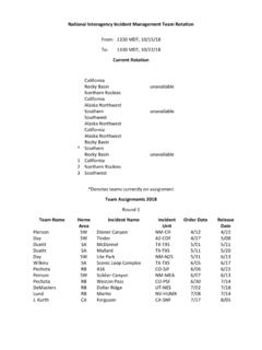
Transcription of Active Incident Resource Summary
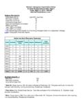
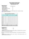
1 National Interagency Coordination Center Incident Management Situation Report Friday, March 9, 2018 0800 MT National Preparedness Level 1 National Fire Activity Initial attack activity: Light (861) new fires New large incidents: 34 Large fires contained: 16 Uncontained large fires:** 15 Area Command teams committed: 0 NIMOs committed: 0 Type 1 IMTs committed: 0 Type 2 IMTs committed: 0 **Uncontained large fires include only fires being managed under a full suppression strategy. Link to Geographic Area daily reports. Active Incident Resource Summary GACC Incidents Cumulative Acres Crews Engines Helicopters Total Personnel AICC 0 0 0 0 0 0 NWCC 0 0 0 0 0 0 ONCC 0 0 0 0 0 0 OSCC 0 0 0 0 0 0 NRCC 1 880 0 0 0 16 GBCC 1 800 1 14 0 67 SWCC 1 335 0 4 0 30 RMCC 5 6,396 0 72 3 316 EACC 0 0 0 0 0 0 SACC 43 52,184 3 180 6 716 Total 51 60,595 4 270 9 1,145 Southern Area (PL 1) New fires: 783 New large incidents: 26 Uncontained large fires: 11 * West 60, Osage Agency, BIA.
2 Six miles northwest of Pawhuska, OK. Tall grass and brush. Extreme fire behavior with crowning, running and torching. Residences threatened. * Faka-Union (11), Florida Forest Service. One mile northwest of Port of the Islands, FL. Southern rough. Extreme fire behavior. * Nora, Osage Agency, BIA. Four miles west of Barnsdall, OK. Tall grass. Extreme fire behavior with crowning, running and spotting. Residences threatened. * CPI 7, Seminole Tribe, BIA. Twenty-three miles southeast of Ave Maria, FL. Timber. Minimal fire behavior with backing. Last report unless significant activity occurs. * Onion Prairie, Oklahoma DOF. Five miles northwest of Ocheleta, OK. Tall grass, brush and timber. Moderate fire behavior with running and flanking. Residences threatened. * Galena, Oklahoma DOF. Twelve miles southeast of Waynoka, OK. Short grass, brush and timber.
3 Minimal fire behavior with smoldering. Residences threatened. * Kane, Osage Agency, BIA. Seven miles west of Bartlesville, OK. Timber, tall grass and brush. Extreme fire behavior. * Paint, Kisatchie NF. Five miles south of Fort Polk, LA. Timber and brush. Minimal fire behavior. * Jon, Wewoka Agency, BIA. Two miles southwest of Seminole, OK. Timber. Minimal fire behavior. Structures threatened. Last report unless significant activity occurs. * Santa Ana NWR, Santa Ana NWR. Seven miles south of Alamo, TX. Grass and brush. Active fire behavior with creeping, backing and flanking. Area closures in effect. Shot, Texas A & M Forest Service. Started on private land nine miles east of Silverton, TX. Tall grass. No new information. Last report unless new information is received. * Mini Ranch RD (28), Florida Forest Service. Four miles southeast of Sebring, FL.
4 Southern rough. Moderate fire behavior. Structures threatened. * Wallen Hollow, Virginia DOF. Started on private land three miles southeast of Jonesville, VA. Minimal fire behavior. Residences threatened. Incident Name Unit Size % Ctn/ Comp Est Personnel Resources Strc Lost $$ CTD Origin Own Acres Chge Total Chge Crw Eng Heli * West 60 OK-OSA 20,307 --- 60 Ctn 03/18 89 --- 0 37 1 0 20K BIA * Faka-Union (11) FL-FLS 7,500 --- 60 Ctn 03/16 61 --- 0 6 1 0 218K ST * Nora OK-OSA 7,000 --- 60 Ctn 03/18 82 --- 0 25 1 0 20K BIA * CPI 7 FL-SEA 4,107 --- 90 Comp UNK 7 --- 0 2 0 0 30K BIA * Onion Prairie OK-OKS 3,439 --- 79 Ctn UNK 26 --- 0 6 1 0 126K ST * Galena OK-OKS 1,011 --- 99 Ctn UNK 4 --- 0 2 0 3 25K ST * Kane OK-OSA 700 --- 60 Ctn 03/10 33 --- 0 14 0 0 4K BIA * Paint LA-KIF 365 --- 50 Ctn UNK 11 --- 0 2 0 0 15K FS * Jon OK-WEA 360 --- 55 Comp 03/12 9 --- 1 2 0 0 4K BIA * Santa Ana NWR TX-STR 330 --- 50 Ctn 03/10 23 --- 0 6 0 0 10K FWS Shot TX-TXS 315 --- 99 Ctn UNK 1 --- 0 0 0 0 1K PRI * Mini Ranch RD (28)
5 FL-FLS 300 --- 66 Ctn 03/09 6 --- 0 2 0 0 36K ST * Wallen Hollow VA-VAS 100 --- 20 Ctn UNK 0 --- 0 0 0 0 4K PRI * Keepers Branch SC-FMF 671 --- 100 Ctn --- 14 --- 0 2 1 0 18K FS * Razorback Mountain OK-SEU 650 --- 100 Ctn --- 6 --- 2 1 0 0 3K ST * White River TX-TXS 577 --- 100 Ctn --- 9 --- 0 0 0 0 1K PRI * Beasley Ranch OK-OKS 560 --- 100 Ctn --- 4 --- 0 2 0 0 16K ST Incident Name Unit Size % Ctn/ Comp Est Personnel Resources Strc Lost $$ CTD Origin Own Acres Chge Total Chge Crw Eng Heli * 2381 TX-TXS 496 --- 100 Ctn --- 0 --- 0 0 0 0 1K ST * Hammon 920 OK-OKS 488 --- 100 Ctn --- 4 --- 0 2 0 0 16K ST * Hurd AR-ARS 433 --- 100 Ctn --- 28 --- 0 2 0 0 1K PRI * Blood-Weeks FL-APQ 377 --- 100 Comp --- 13 --- 0 3 0 0 5K DOD * Signboard Road VA-VAS 302 --- 100 Ctn --- 6 --- 0 1 0 0 5K PRI * Myers TX-TXS 275 --- 100 Ctn --- 15 --- 0 0 0 0 1K PRI * Vestry Rd MS-MSS 165 --- 100 Comp --- 3 --- 0 0 0 0 33K PRI * Pipeline OK-SEU 120 --- 100 Ctn --- 4 --- 0 2 0 0 3K ST * Saddle Club Road NC-NCS 109 --- 100 Ctn --- 26 --- 0 5 0 0 9K ST * Fred West Rd MS-MSS 100 --- 100 Comp --- 3 --- 0 0 0 0 20K PRI FMF Francis Marion & Sumter NF SEU Southeast Area, Oklahoma DOF ARS Arkansas Forestry Commission APQ Avon Park AFB MSS Mississippi Forestry Commission NCS North Carolina Forest Service Southwest Area (PL 1) New fires: 31 New large incidents: 2 Uncontained large fires: 1 Anderson Ranch, Capitan District, New Mexico State Forestry.
6 Started on private land 20 miles northwest of Lovington, NM. Tall grass and brush. No new information. Last report unless new information is received. Incident Name Unit Size % Ctn/ Comp Est Personnel Resources Strc Lost $$ CTD Origin Own Acres Chge Total Chge Crw Eng Heli Anderson Ranch NM-N5S 1,000 --- 85 Ctn UNK 18 --- 0 6 0 0 15K PRI * Kendrick AZ-COF 335 --- 100 Ctn --- 30 --- 0 4 0 0 30K FS * Beamer NM-N2S 300 --- 100 Ctn --- 0 --- 0 0 0 0 4K ST COF Coconino NF N2S Cimaron District, New Mexico State Forestry Rocky Mountain Area (PL 1) New fires: 18 New large incidents: 4 Uncontained large fires: 1 * Clark County, Clark County. Five miles southwest of Ashland, KS. Grass. Minimal fire behavior. Incident Name Unit Size % Ctn/ Comp Est Personnel Resources Strc Lost $$ CTD Origin Own Acres Chge Total Chge Crw Eng Heli * Clark County KS-CAX 1,600 --- 95 Ctn UNK 182 --- 0 49 0 0 1K C&L * Boller KS-GEX 1,040 --- 100 Ctn --- 54 --- 0 4 0 0 9K C&L * I-70 Milepost 310 KS-GEX 600 --- 100 Ctn --- 42 --- 0 12 0 0 7K C&L * Forest Ridge CO-ELX 374 --- 100 Ctn --- 0 --- 0 0 0 9 1K C&L GEX Geary County ELX Elbert County Great Basin Area (PL 1) New fires: 7 New large incidents: 1 Uncontained large fires: 1 * Chimney, Humboldt County.
7 Started on private land three miles east of Paradise Valley, NV. Brush and short grass. Extreme fire behavior with torching and running. Structures threatened. Evacuations in effect. Incident Name Unit Size % Ctn/ Comp Est Personnel Resources Strc Lost $$ CTD Origin Own Acres Chge Total Chge Crw Eng Heli * Chimney NV-HUMX 800 --- 40 Ctn 03/09 67 --- 1 14 0 0 10K PRI Northern Rockies Area (PL 1) New fires: 1 New large incidents: 1 Uncontained large fires: 1 * March 7, Maggie Creek Area, IDL. Six miles east of Nez Perce, ID. Grass. Moderate fire behavior with running and backing. Structures threatened. Evacuations, road, area and trail closures in effect. Incident Name Unit Size % Ctn/ Comp Est Personnel Resources Strc Lost $$ CTD Origin Own Acres Chge Total Chge Crw Eng Heli * March 7 ID-MCS 880 --- 95 Ctn 3/10 16 --- 0 0 0 0 10K ST Fires and Acres Last Week (by Protection).
8 Area BIA BLM FWS NPS ST/OT USFS TOTAL Alaska Area FIRES 0 0 0 0 0 0 0 ACRES 0 0 0 0 0 0 0 Northwest Area FIRES 0 0 0 0 0 0 0 ACRES 0 0 0 0 0 0 0 Northern California Area FIRES 0 1 0 0 8 0 9 ACRES 0 0 0 0 2 0 2 Southern California Area FIRES 0 0 0 0 0 0 0 ACRES 0 0 0 0 0 0 0 Northern Rockies Area FIRES 0 0 0 0 1 0 1 ACRES 0 0 0 0 880 0 880 Great Basin Area FIRES 1 1 0 0 5 0 7 ACRES 1 0 0 0 874 0 875 Southwest Area FIRES 5 2 0 0 20 4 31 ACRES 0 40 0 0 2,230 420 2,690 Rocky Mountain Area FIRES 0 1 0 0 15 2 18 ACRES 0 0 0 0 8,485 3 8,488 Eastern Area FIRES 0 0 0 0 0 12 12 ACRES 0 0 0 0 0 75 75 Southern Area FIRES 34 0 0 2 727 20 783 ACRES 7,453 0 0 105 15,210 1,060 23,828 TOTAL FIRES: 40 5 0 2 776 38 861 TOTAL ACRES: 7,454 40 0 105 27,681 1,558 36,838 Fires and Acres Year-to-Date (by Protection): Area BIA BLM FWS NPS ST/OT USFS TOTAL Alaska Area FIRES 0 1 0 0 0 0 1 ACRES 0 0 0 0 0 0 0 Northwest Area FIRES 1 2 0 0 2 6 11 ACRES 1 0 0 0 1 0 2 Northern California Area FIRES 0 6 0 0 130 12 148 ACRES 0 10 0 0 98 13 121 Southern California Area FIRES 1 1 0 0 322 22 346 ACRES 0 28 0 0 2,194 6 2,228 Northern Rockies Area FIRES 0 0 0 0 1 1 2 ACRES 0 0 0 0 880 0 880 Great Basin Area FIRES 2 18 0 1 26 5 52 ACRES 3 654 0 0 1,456 13 2,126 Southwest Area FIRES 75 20 0 2 84 37 218 ACRES 504 139 0 20 12,636 543 13,842 Rocky Mountain Area FIRES 6 2 2 0 57 6 73 ACRES 6 11 5 0 26,043 11 26,076 Eastern Area FIRES 0 0 0 0 80 48 128 ACRES 0 0 0 0 53 3,943 3,996 Southern Area FIRES 173 67 8 6 6,352 82 6,688 ACRES 32,606 310 859 156 107,588 6,899 148,418 TOTAL FIRES: 258 117 10 9 7,054 219 7,667 TOTAL ACRES.
9 33,120 1,152 864 176 150,949 11,428 197,689 Prescribed Fires and Acres Last Week (by Ownership): Area BIA BLM FWS NPS ST/OT USFS TOTAL Alaska Area FIRES 0 1 5 0 0 2 8 ACRES 0 17 982 0 0 1,097 2,096 Northwest Area FIRES 0 0 0 0 0 6 6 ACRES 0 0 0 6 0 155 161 Ten Year Average Fires (2007 2016 as of today) 7,091 Ten Year Average Acres (2007 2016 as of today) 232,357 Northern California Area FIRES 0 0 0 0 0 9 9 ACRES 0 0 0 0 0 1,061 1,061 Southern California Area FIRES 0 0 0 0 0 0 0 ACRES 0 0 0 0 0 0 0 Northern Rockies Area FIRES 0 2 0 0 5 2 9 ACRES 2 108 0 15 9 45 179 Great Basin Area FIRES 0 1 0 0 0 7 8 ACRES 0 3,500 0 0 0 4,252 7,752 Southwest Area FIRES 0 0 1 0 0 2 3 ACRES 0 94 813 0 0 1,585 2,492 Rocky Mountain Area FIRES 0 0 2 0 1 9 12 ACRES 0 0 410 0 170 11,220 11,800 Eastern Area FIRES 13 0 17 3 4,490 79 4,602 ACRES 2,988 0 14,614 3,605 160,592 100,303 282,102 Southern Area FIRES 0 1 5 0 0 2 8 ACRES 0 17 982 0 0 1,097 2,096 TOTAL FIRES: 13 4 25 3 4,496 116 4,657 TOTAL ACRES: 2,990 3,719 16,819 3,626 160,771 119,718 307,643 Prescribed Fires and Acres Year-to-Date (by Ownership).
10 Area BIA BLM FWS NPS ST/OT USFS TOTAL Alaska Area FIRES 0 0 2 0 0 0 2 ACRES 0 0 55 0 0 0 55 Northwest Area FIRES 0 21 5 2 0 45 73 ACRES 0 1,670 982 5 0 6,510 9,167 Northern California Area FIRES 0 3 2 6 0 86 97 ACRES 0 1,792 6 65 0 9,464 11,327 Southern California Area FIRES 0 1 0 0 0 65 66 ACRES 0 15 0 0 0 8,185 8,200 Northern Rockies Area FIRES 0 4 0 0 1 4 9 ACRES 0 152 0 0 6 89 247 Great Basin Area FIRES 2 11 0 5 25 40 83 ACRES 75 249 0 80 337 4,348 5,089 Southwest Area FIRES 10 9 5 3 1 61 89 ACRES 1,672 7,836 205 86 51 12,774 22,624 Rocky Mountain Area FIRES 5 11 2 9 26 86 139 ACRES 111 231 814 263 1,207 33,877 36,503 Eastern Area FIRES 0 0 24 1 45 42 112 ACRES 0 0 1,990 7 3,315 13,416 18,728 Southern Area FIRES 67 0 77 12 28,772 364 29,292 ACRES 17,306 0 60,723 17,253 1,012,338 346,763 1,454,383 TOTAL FIRES: 84 60 117 38 28,870 793 29,962 TOTAL ACRES: 19,164 11,945 64,775 17,759 1,017,254 435,426 1,566,323 ** Changes in some agency YTD acres reflect more accurate mapping or reporting adjustments.