Transcription of April 18-19 Coastal Storm - National Weather Service
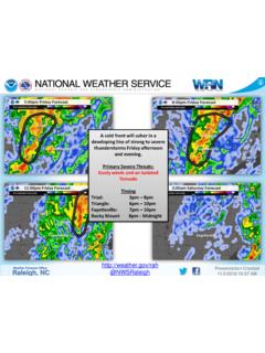
1 Philadelphia/Mount HollyWeather Forecast Office Presentation Created 3/12/2022 3:58 AM@NWS_MountHollyNWSM ountHollyMulti-Hazard Storm Expected Today and TonightWhat Has Changed? Winter Storm Warning and Winter Weather Advisory expanded a little further southeast Some increase in snow amounts near the I-95 corridorDecision Support Briefing #4As of 5:00 AMSaturday, March 12, 2022 Philadelphia/Mount HollyWeather Forecast Office Presentation Created 3/12/2022 3:58 AM@NWS_MountHollyNWSM ountHollyMain PointsHazardImpactsLocationTimingHeavy SnowSnowwith amounts ranging from 5 to 8 inches, resulting in hazardous driving conditions with an accumulation on Poconos, Berks County, the Lehigh Valley and northwestern New JerseyMidmorning through late afternoon amounts ranging from 2 to 5 inches, which may result in hazardous driving conditions with an accumulation especially on untreated , parts of northern, central, and southern NJ, northern DE, Kent Co MDLatemorning through late afternoon freezeA rapid temperature drop following a brief transitionto snow could produce icy road central and southern New Jersey, Delaware and eastern MarylandThis afternoonand northwestwind 20 to 30 MPH with gusts of 40to 50 MPH.
2 Scattered tree and utility pole/wire damage is Pennsylvania,New Jersey, Delaware and eastern MarylandThis afternoon wind 20 to 30 knots with gusts of 35 to 45 knots, creating hazardous of Delaware and New Jersey, and Delaware BayThis afternoon through SundaymorningPhiladelphia/Mount HollyWeather Forecast Office Presentation Created 3/12/2022 3:58 AM@NWS_MountHollyNWSM ountHollyMarine: Coastal Waters of NJ/DE and Delaware BayNoneLimitedElevatedSignificantExtreme Summary of Greatest ImpactsNoneLimitedElevatedSignificantExt remeNoneLimitedElevatedSignificantExtrem eHeavy Snow: Poconos/Berks/Lehigh Valley/NW NJNoneLimitedElevatedSignificantExtremeF lash freeze: East MD, DE, central and south NJNoneLimitedElevatedSignificantExtremeS now: North DE, SE PA, N, C, SW NJWind: East PA, NJ, DE and east MDPhiladelphia/Mount HollyWeather Forecast Office Presentation Created 3/12/2022 3:58 AM@NWS_MountHollyNWSM ountHollyExpected Snowfall Accumulations Rain changing to snow from this morning into early afternoon Heavy snow rates and near blizzard conditions likely late morning and early afternoon Snow tapers off and gradually ends late this afternoon and early of greatest uncertainty depending on the timing of the change from rain to HollyWeather Forecast Office Presentation Created 3/12/2022 3:58 AM@NWS_MountHollyNWSM ountHollyWind Advisory/Gale Warning Northwest wind 20 to 30 MPH with gusts of 40 to 50 MPH.
3 The strongest of the winds should occur from this afternoon into tonight. Some tree damage is possible and it could lead to localized power outages. Rough boating conditionsXPhiladelphia/Mount HollyWeather Forecast Office Presentation Created 3/12/2022 3:58 AM@NWS_MountHollyNWSM ountHolly Winter Storm Warnings/Winter Weather Advisoriesare in effect for portions eastern Pennsylvania, New Jersey, northern Delaware, and the Eastern Shore of MD. This includes some expansions of previous Warnings and Advisories. Snow covered roads and hazardous driving conditions are likely. Near blizzard conditions are likely for a time late this morning and early this afternoon especially in the Winter Storm Warning area. A flash freezeon wet untreated sidewalks and roadways may occur on this afternoon and evening as temperatures drop rapidly below freezing.
4 Windy conditions are expected this afternoon and tonight. Gusts of 40 to 50 mph are likely, potentially leading to scattered power outages. A Wind Advisoryis in effect. A Gale Warningis in effect for the Coastal waters of New Jersey and Delaware, and for Delaware Bay from this morning into Sunday SummaryPhiladelphia/Mount HollyWeather Forecast Office Presentation Created 3/12/2022 3:58 (public):(609) 261-6600 Facebook:NWSM ountHollyTwitter:@NWS_MountHollyContact and Next Briefing InformationBriefing Webpage: Briefing When: Final :The information contained in this briefing is time-sensitive, do not use after Saturday, March 12.


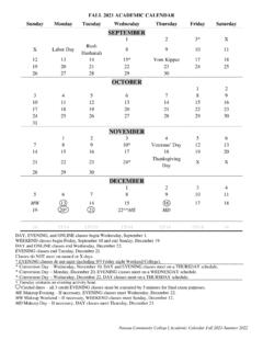
![Academic Calendar 21-22-Revised[4] - Alamo Colleges …](/cache/preview/7/f/7/6/d/7/1/5/thumb-7f76d715407cec05510b8ae226f064e4.jpg)