Transcription of at 1-877-FEMA MAP Flood Zone? - Miami-Dade
1 Understanding your Flood map The Water Cycle Precipitation falls from clouds to the earth as rain, snow or ice. people, businesses and farms. Water can also flow through Questions about Flood maps Call the Miami-Dade County Flood Zone Hot Line Do You Know Your An average of 52 inches of rain falls on South Florida each year. aquifers to refill lakes and rivers and sometimes bubble out at 305-372-6466, Monday through Friday, from 8 to 5 To identify a community's Flood risk, the Federal Emergency Excess water, called runoff, flows from land into ponds, lakes, of the ground as freshwater springs. Management Agency ( fema ) conducts a Flood Insurance or canals. In South Florida, the water also flows into wetlands, Call the fema Map Assistance Center at 1-877-FEMA MAP. marshes or estuaries and into the Atlantic Ocean or Gulf The sun heats up the earth's surface, causing water to turn (1-877-336-2627), Monday through Friday, 8 to 6:30 , for Study.
2 The study includes information on canal and stream Flood Zone? of Mexico. to vapor as it evaporates. Plants release water through flows, storm tides, hydrologic/hydraulic analyses, and rainfall information and assistance on how to obtain Flood maps. transpiration. Together, all the water rising into the air is and topographic surveys. fema uses this data to create the Some rainfall slowly seeps, or percolates, into the ground to called evapotranspiration. The warm vapor continues to Flood hazard maps the Digital Flood Insurance Rate Maps You can also view the maps online recharge, or refill, the underground layer of sand, gravel or rock. rise until it reaches cooler air; it condenses into very small at (DFIRMs) that outline your community's different Flood risk These layers, called aquifers, hold water.
3 In South Florida, wells droplets or ice crystals, forming clouds. areas. fema periodically updates those maps and it is currently are drilled into some aquifers to pump out water needed for To view printed copies of the maps, updating the map for Miami-Dade County. Below are the please visit the following locations: definitions for all the Flood zone designations shown in Miami-Dade County's DFIRMs. It is all connected Miami-Dade RER, Miami-Dade Miami-Dade RER, Make sure that only rain gets into Water Management RER, Downtown West dade ZONE AE (Moderate to High Flooding Risk) CONDENSATION the drainage system by correctly Division Environmental Plan Environmental This is the Flood insurance rate zone that corresponds with PRECIPITATION disposing of trash and landscape 701 NW 1 Court, Review Office Plan Review Office Flood depths greater than three feet.
4 Mandatory Flood insurance debris. It is ILLEGAL to throw away Suite 500 701 NW 1 Court, 11805 SW 26 Street purchase requirements apply. or discharge anything into the rivers, miami , FL 33136 Suite 200 miami , FL 33175. ZONE AH (Moderate to High Flooding Risk) canals, lakes, bays or any waters 305-372-6529 miami , FL 33136 786-315-2800. EVAPOTRANSPIRATION. This is the Flood insurance rate zone that corresponds to areas in Miami-Dade County. By law, 305-372-6899. of shallow flooding with average depths between one and three nothing but rainwater is allowed to be feet. Mandatory Flood insurance purchase requirements apply. discharged into the storm drains. If ZONE VE (High Flooding Risk) This is the Flood you witness dumping of any liquid or Questions about RUNOFF. insurance rate zone that corresponds to coastal areas that materials into storm drains or waters have additional hazards associated with storm waves.
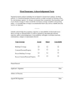
5 There is at least a one-in-four chance of flooding during a 30-year mortgage. Mandatory Flood insurance requirements apply. AQUIFERS. of the County, please call the 24-hour Environmental Emergency Hot-Line at 305-372-6955, or Miami-Dade Crime Flood insurance Important new Zone A (unnumbered) (High Flooding Risk). Because detailed analyses are not performed for such areas, RECHARGE. Stoppers at 305-471-TIPS (8477). Visit or speak with your insurance agent. For information on coverage and rates developments no depths or base Flood elevations are shown within these zones . There is at least a one-in-four chance of flooding during call 1-800-427-4661. Para obtener una copia de este folleto en espa ol, visite for you to a 30-year mortgage. Mandatory Flood insurance requirements also apply.
6 Nuestra p gina web al library/ know Zone D Areas with possible but undetermined Flood BISCAYNE BAY SALINITY. CONTROL Pou jwenn yon kopi bwochi sa a an krey l, vizite sit ent n t nou hazards. No Flood hazard analysis has been conducted. Flood STRUCTURE. an nan fema is working on insurance rates are commensurate with the uncertainty of the Flood risk. In Miami-Dade County, most of these areas fall within Everglades National Park. Wetlands are our friends P RI. MA. RY C AL. E. INLET. updating the Flood zone Did you know that rainfall is an important part of the ANA. L SW. PERFORATED. For a copy of this publication in an accessible format, maps for Miami-Dade ecology of South Florida? Rainfall drains into floodplains PIPE please call 305-514-6653. In moderate-to-low-risk areas, the chance of being flooded is County.
7 The publication reduced but not completely removed. These areas submit more such as the Everglades and our many wetlands, filters FRENCH DRAIN. through these areas, and is eventually stored OUTFALL. than 20 percent of the NFIP claims and receive one-third of all underground. Underground water is the only source of SEC LAKE of the draft maps is disaster assistance for flooding. Flood insurance isn't federally ON D GROUNDWATER. A RY. required in moderate-to-low areas, but it is recommended for drinking and domestic water supply in South Florida. It is CA N. AL. scheduled for 2019. all property owners and renters. They are shown on Flood maps important that we protect and maintain these drainage as zones labeled with the letter X (or a shaded X). areas; the quality of our drinking water depends on it!
8 123_01-1 9/17. Why do floods occur? Get an Elevation Certificate Retrofitting your home If you live in a condo Weather warnings /. Because Miami-Dade County is located in a unique geographical area, it is particularly susceptible to flooding from Once you have determined that your house lies in a Flood zone, an Elevation Certificate can then tell you how high your house All construction in Miami-Dade County requires the issuance of building permits prior to construction. Building permits are If you live in a condominium, private community with an association, or if your place of business is located in a watches. major rain events and storm surge. The County is surrounded by was built in relation to that Flood zone. These Certificates are obtained after submittal and approval of building plans.
9 An commercial property such as a warehouse or shopping mall, The National Weather Service monitors local weather major water bodies, the Atlantic Ocean, Biscayne Bay, and many required for all new construction, as well as for construction important part of the review process is the requirement that then you should become familiar with the drainage system in conditions. If flooding from rain is anticipated, the Service projects that involve making substantial improvements to a your private community and/or place of business. Specifically, will broadcast Flood Warning Notices through television, rivers, lakes and canals. Miami-Dade County lies close to sea structures be built high enough and use proper design to protect structure. An Elevation Certificate is an important document that you should be aware of the location, condition and operation of radio and wire services.
10 These notices are intended to make level and its underground water supply is just below the ground against Flood damage. If you plan to construct an addition to your every homeowner should have, and in case of a disaster, would the on-site drainage system that your homeowner's association you aware and help you prepare for possible flooding. If an surface. Therefore, major rain events sometimes leave demonstrate to County authorities that your house is at or above house, build a new house, or for any other type of development, or place of business is responsible for maintaining. It is also a Emergency Flood Warning Notice is issued, the National rainwater nowhere to drain, causing occasional flooding in some the required elevation. If the Certificate shows that your house is call Miami-Dade County's Department of Regulatory and good idea to develop a list of important contact persons/phone Weather Service will broadcast this warning through the areas of the County.