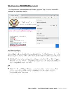
Transcription of Basic Coordinates & Seasons – Student Guide
1 Name: Basic Coordinates & Seasons Student Guide There are three main sections to this module: terrestrial Coordinates , celestial equatorial Coordinates , and understanding how the ecliptic is related to Seasons on the Earth. Each of these sections has its own simulator(s). The background material necessary to utilize these tools is contained in each section. Terrestrial Coordinates Work through the explanatory material on units of longitude and latitude, finding longitude and latitude, and a bit of history (optional).
2 Open the flat map explorer. Familiarize yourself with the cursor and how it prints out the longitude and latitude of the active map location. Note that you can vary the central meridian of the map ( change its longitude). Use the shift map arrows at the top of the simulator to affect large rapid changes. Use the shift-click feature of the cursor for finer control. Note what information is accessible through the show cities and show map features check boxes. Center the cursor on your present location. Click the open Google Maps button to launch the Google Map tool focused on this location.
3 Experiment until you get a good feeling for the Google Map's capabilities and then close this window. (Note that you must be connected to the Internet to make use of this feature.). Question 1: Use the flat map explorer to complete the following table. You are encouraged to try and predict the answers and then use the map's cursor and other features to check the accuracy of your estimates. Location Longitude Latitude The center of the island of Madagascar. W N. Prime Meridian N. W Tropic of Cancer Sao Paulo, Brazil International Date Line Arctic Circle 90 W Meridian 30 N Parallel Question 2: Determine which of the 50 states defines the farthest extent of the United States in each of the 4 map directions.
4 NAAP Basic Coordinates & Motions 1/8. Direction State North South East (there are two ways of thinking about this). West Question 3: The exact Coordinates of the white house in Washington , are . W and N. What are these exact Coordinates in sexagesimal notation? Show your calculation in the box below. (You can use the Google Map tool to check your answer.). Open the globe explorer. You are encouraged to use the Terrestrial Coordinate Explorers link which opens both simulators at the same time for the following two questions.
5 Familiarize yourself with the features noting that they are very similar to those in the flat map explorer. Question 4: A) Where is the north pole on the flat map explorer? What is its shape? B) Where is the north pole on the globe explorer? What is its shape? C) Your answers to parts A and B should be different. Explain why. NAAP Basic Coordinates & Motions 2/8. Question 5: Compare the relative sizes of Greenland and Australia in the two maps? The true values of the surface areas for these countries are Greenland ( million km2) and Australia ( million km2).
6 Does each map demonstrate these true values? Celestial Equatorial Coordinates Work through the introductory material on the page entitled Celestial Equator, Declination, Right Ascension. Open either the Flat Sky Map Explorer or the Sky Map Explorer. Familiarize yourself with the same set of features (cursor movement, shifting the map, decimal/sexagesimal) that were available on the previous maps. Make sure that you understand what each check box does. Question 6: Where is the star Polaris located on this map? What are its Coordinates ?
7 Question 7: Find the constellation of Orion shown in the box below and measure the right ascension and declination of its brightest stars Betelgeuse and Rigel. Note that Orion is located on the celestial equator. RA RA. DEC DEC. NAAP Basic Coordinates & Motions 3/8. Question 8: Which direction is east on the flat sky map? Relate this to a coordinate of the celestial equatorial system. Question 9: Complete the following table of positions on the ecliptic. Ecliptic Location Approximate Date Right Ascension Declination Vernal Equinox March 21.
8 Summer Solstice June 21. Autumnal Equinox December 21. Question 10: Write out a description of the ecliptic on the flat sky map. What does the shape look like? Describe the ecliptic in terms of its average and range of declination values. Seasons and the Ecliptic Work through the introductory material on the page entitled Orbits and Light. Open the Seasons and Ecliptic Simulator. Note that there are three main panels (left, upper right, and lower right) each of which have two different views. Controls run along the bottom of the simulation that affect more than one panel.
9 Click animate and then move through the six views to get an overview this simulator's capabilities. We will address each of these six views separately. Experiment with the various methods to advance time in the simulator. You may click the start animate/stop animation button, drag the yearly time slider, or drag either the sun or the earth in the left panel to advance time. Note that this animation does not illustrate the rotation of the earth. Because the timescales of rotation and revolution are so different, it isn't possible to effectively show both simultaneously.
10 NAAP Basic Coordinates & Motions 4/8. Left Panel Orbit View Practice clicking and dragging in this panel to change the Tip: Note that if you click and drag the perspective. Change the perspective so that you are Earth, you will looking directly down onto the plane of the Earth's orbit change the date and location rather than Click labels. Note that you can see how the direct rays of the perspective. the sun hit at different latitudes throughout the year. Experiment with this view until you can quickly create the two views shown below.