Transcription of Batona Trail - New Jersey
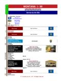
1 Batona Batona Trail Trail Pinelands Pinelands National Reserve Batona Trail Pinelands National Reserve National Reserve The 50-mile long Batona Trail derives Plant and animal species that are rare, and Four Mile. The Trail is marked with pink its name from the words BAck TO in some cases, unique to the Pinelands can blazes, and there are several major roads NAture. It crosses vast tracts of New be found along the route. The Trail passes that intersect it, making it easy to plan Jersey 's Pinelands National Reserve.
2 Through some of South Jersey 's forgotten hikes of varying lengths. towns like Martha, Lower Forge and Mount Batona Trail Mileage Table SOUTHAMPTON. SOUTHAMPTON Presidential Lake Mount Misery Misery Batona Trail Mileage Table Retreat Presidential Lake Estates 206 P Mount Location Batona Trail Mileage Table Miles Deep Estates SOUTHAMPTON. 206 Retreat N. P. Ongs Ongs Hat Deep Hollow Pond Presidential Lake Lebanon Lake Misery Location Miles North - South South - North Retreat N Hat Hollow Earlys Pond Estates Lebanon Lake Estates North - South South - North Crossing 206 P Earlys Estates Location Miles Ongs Crossing Hollow Ongs Hat 0 50.
3 Deep Beaverville N Hat Presidential LakesLebanon Lake BRENDAN T. BYRNE Ongs Hat North0 - 50- Beaverville Earlys Pond Four LakesMile Presidential Estates BRENDANSTATE. T. BYRNE Deep Hollow Road Four Mile Crossing Circle FOREST Deep Hollow RouteRoad 70 Circle STATE FOREST Ongs70 Hat 0 50. Red Beaverville 70 P. Presidential BRENDAN T. BYRNE Route Lebanon Tower 70 P Mile LakesLeban Four Four MileFourLMile Deep Hollow Lebanon Road TowerPond Red Lion eb Circle on STATE FOREST Pakim Lion an RoutePond Pakim 70 Fir Burrs Mill on eT Route 72 Red Burrs Mill 70 P Fir ow Lebanon Route Tower 72 Route eT er Four Mile Le ba ow 563 er Lion no nF Pakim Pakim Route Pond 563.
4 Route 532 Burrs Mill ire PakimP Pond Route532. Route 72 P Apple Pie Hill Tower To we r Pond P RoutePie Apple 563. Hill Tower State Hospital State Hospital P. Pakim Brendan T . Byr ne Batona Camp P Route Camp Batona 532 Carranza Memorial Friendship Brendan T. Pond Camp . Byr ne Oak Shade Friendship Sooy Place Camp P Apple Pie Carranza Hill Tower Memorial Oak Shade Sooy Place State Hospital 72 Hay Road Batona Hay RoadCamp Moores Friendship Johnson Johnson Place Brendan T. 72. Camp . Byr ne Lower Forge Camp off Oak Shade Mill Carranza Lower ForgeMemorial Camp Turn off Moores Mill Sooy Place Place Quaker Bridge Fox Hedger Hay Road Quaker Bridge Fox Chase Johnson Hedger House 72 Washington Pike & Batsto Moores Lower Forge Washington Camp Pike Turn off & Batsto Chase Mill Place House Buttonwood Hill Camp Turn off Quaker Bridge Buttonwood Hill Bridge Camp Turn off Fox Hedger 563 Evans Chase Tabernacle House 563 Washington Evans BridgePike & Batsto Tabernacle WOODLAND.
5 WOODLAND Route Route 679. Buttonwood 679 Hill Camp Turn Martha Bridge 563 EvansBridge Bridge Martha Stage Road Tabernacle FRANKLIN PARKER PRESERVE. WOODLAND. FRANKLIN PARKER PRESERVE Route Stage Martha Coal 679. Road Coal Road RoadBridge 50. 50 0. FRANKLIN PARKER PRESERVE Stage Road TABERNACLE. TABERNACLE. Bozarthtown Whitehorse Whitehorse Coal Road 50 0. Flyat Bozarthtown Chatsworth Flyat Chatsworth 532. Bozarthtown TABERNACLE Whitehorse 532. Flyat Oriental Chatsworth Map Legend Oriental 532 Map Legend Oriental Apple Pie FranklinMapParker Legend Preserve Hampton Apple Pie Hill Franklin Parker Preserve Hill Hampton Gate State Forest Gate Apple Pie Dukes State Forest Franklin Parker Preserve Hill Dukes Bridge Hampton Pine Bridge Elevations in Meters 20.
6 Indian Gate Pine Crest State Forest Elevations in Meters 20. Indian Mills Crest Dukes Mills Bridge Rivers & Lakes SHAMONG Pine Elevations Rivers & Lakesin Meters 20. Ba tona SHAMONG. Indian Mills Ba tona Camp Camp Crest Wetland Area Rivers &Area Wetland Lakes SHAMONG W H A RBaCarranza TtonaO N Carranza W H A R T O NCamp Memorial Park Office RED. 70. BRENDAN. LION. BRENDAN T. BYRNE. STATE FOREST. T. BYRNE. Memorial Wetland Park OfficeArea RED LION. 541. 70. 532. STATE FOREST. NOT TO. Carranza High 541 BERLIN 532 BRENDANNOT TO SCALE.
7 W H A R T O NHigh Memorial Crossing RestroomsBERLIN. 206. 70. T. BYRNE. STATE FORESTSCALE 72. Park Office CHATSWORTH. Restrooms 206. RED534. LION. Crossing CHATSWORTH563. 532 NOT TO. 72. P P. 534 541 WHARTON. 563. High Parking BERLIN 73 WHARTON PENNSCALE. STATE FOREST. Restrooms 206 ATSION. Hampton Crossing Parking 73 ATSION CHATSWORTH. PENN. STATE STATE FOREST. 72. Hampton Furnace 534 536 STATE 563 539. Furnace Telephone P Telephone 536 WHARTON. 539. Parking FOREST. Y. HAMMONTON PENN STATE FOREST BASS RIVER. Friendship 73 ATSION.
8 PK. 206 Hampton HAMMONTON AT FOREST BASS RIVERSTATE FOREST. Y. STATE. PFurnace Friendship L 9. PK. Water 536 AN 542 BATSTO. STATE FOREST 539. 206 AT. 9 ATE. PLake Atsion Telephone Water LA. N. TI542. C. BATSTO. E ST. Atsion Atsion 542. TI FOREST TAT EXIT. Y. HAMMONTON C BASS S RIVER. Lake Friendship C IT 30 52. Atsion 542 STATE. PK. Y. 206. BAtsion P Picnic Area AT. LA. C. IT 30. 563 EXIT. 52. FORESTEXIT. 50 9. BU UR WaterArea Picnic N. TI. Y 542 E BATSTO. XP 563 EXIT. EGG 50 TAT. E. RL LakeLIN Atsion C EX R S GREAT.
9 PR E SS HARBOR. 542 N GREAT. H. C EGG EXIT E BAY. BAY. Camping Area ay CITY. GT Lo w er ES 30 W. EN. GREAT. D. IT. BU INGT. HARBOR 52. GREAT. H. A. GA R. Y. Picnic Area Camping Area SW CITY563Y BAY. BAY. EXIT. ay Lo w er For ge ON. D. EX AY 50. GA R. For ge Camp RL ON PR EGG. CO O. CO. Ro Camp GREAT. IN Lower Swimming ES HARBOR EN. GREAT. H. C C. S T A T ELoForwge FOREST SW BAY. O . ad BAY. GT CO. Ro Camping Area ay CITY. IAC NCC C O.. er Swimming D. Forge . Lower AY. GA R. NT DE TIC N C. TI EN. S TAT E FOREST. ad ON.
10 Dutchtown Camp Forge AON.. Batona Trail LA M N DE. CO. Ro TLC AO. Dutchtown S TAT E Lower FOREST Swimming Batona Trail AT CATLA AM. ad . Forge Other Hiking Trails A C. Dutchtown Quaker Bridg e Camp Other BatonaHiking TrailTrails Quaker Bridge Bridg e Bridge Camp 563 Sand / Gravel Road 563 Sand Other/ Gravel Hiking Road Trails Quaker Bridg e Bridge Camp Paved Road 563 Jenkins Paved Sand Road / Gravel Road Mullica Jenkins Mullica Riv er Camp Paved Road Riv er Camp Jenkins Mullica Martha Mount Bridge Martha Riv er Mount Martha Camp Bridge Martha WASHINGTON.