Transcription of Batona Trail - State
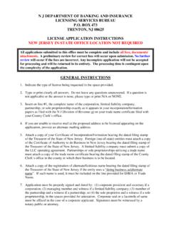
1 Plant and animal species that are rare, and in some cases, unique to the Pinelands can be found along the route. The Trail passes through some of South Jersey s forgotten towns like Martha, Lower Forge and Four Mile. The Trail is marked with pink blazes, and there are several major roads that intersect it, making it easy to plan hikes of varying lengths. Batona Department of the InteriorNational Park ServiceState of New JerseyDivision of Parks & ForestryState of New JerseyPinelands CommissionThe New Jersey Division of Parks & Forestry, the New Jersey Pinelands Commission and the National Park Service are working together to enhance public understanding, awareness and appreciation of natural and cultural resources of the Pinelands National ReserveWHA R T ONSOUTHAMPTONM ountMise ryBatst oWOODLANDCh atsworthTABERNACLESHAMONGMULLICALITTLE EGG HARBORBASS RIVERWASHINGTONFour Mil eCircleHedgerLowerForgeBRENDANT. BYRNESTATE FORESTHi ghCrossingHouseRedLionMountApp le Pi eHil lInd ianMill sAtsionHammontonMunicipal Airpo rtCAMDEN GTON C rnaceHampton GateTabe rna cleNescoWestcoatv ill ePl easantMill sSweetwate rCrowleytownTylertownBu ll townMaxwellHarrisv ill eJenkinsMarth aGreenbankLower BankWad ingRiverLeektownMunionFieldBe avervill eRet reatFriendshipFoxChaseMooresMil lOak S hadeBozarthtownSooy Pl ac eBu rrs Mil lJohnsonPl ac eDu kesBr idg ePi neCres tFriendshipDutcht ownHermanWes tTuckerto nNug ent ownGi ffordt ownRacetrackFour Mil e E arlysCrossingWhitehorseLebanon La keEst ate sPres idential La keEst ate sFlyatState HospitalBASS RIVER State FORESTS T A TE FOREST7072563542539 GARDEN State PARKWAY563 Qua kerBr idg eBa tonaCampF or geCampLo w er679532 Riv erCampMullic aOrientalHillCampBut tonwoodCampBodin eBridgeCampCampBrendan T.
2 ByrneAbsegamiCampLake542563206206 NewGretna5429 FRANKLIN PARKER PRESERVEB atonaTrail Mileage TableMap LegendPPark OfficeRestroomsParkingTelephoneWaterPicn ic AreaCamping AreaWetland AreaRivers & LakesElevations in MetersState Forest20 Franklin Parker PreserveBatonaTrailOther Hiking TrailsPaved Road SwimmingSand / Gravel Road Location Miles North - South South - NorthOngs HatDeep Hollow RoadRoute 70 LebanonTowerPakim PondRoute 72 Route 563 Route 532 Apple Pie Hill TowerBatona CampCarranza MemorialHay RoadLower Forge Camp Turn offQuaker BridgeWashington Pike & BatstoButtonwood Hill Camp Turn offEvans BridgeRoute 679 Martha BridgeStage RoadCoal Road 0 50 50 0 PPPPPPPCoalRoadStageRoadWashingtonPikeHa yRoadEvansBridgeMarthaRoadMarthaBridgeCa rranzaMemorialPakimPondLebanon Fire TowerHollowPondDeepOngsHatHarrisvilleLak eLakeAbsegamiBatstoLakeAtsionLakePreside ntial LakesExit52 ATLANTICCITYEXPRESSWAY20630542 PENN State FORESTHAMMONTONGREATNOTTO SCALEBAY9 BRENDANT.
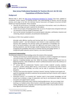
3 BYRNE State BASS RIVERSTATE FORESTWHARTON State FORESTATSION206563 EGGHARBORCITY539 CHATSWORTH73534536541 BERLINRED LIONEXIT50 GREAT BAYBATSTO5635327270 NKilometersMilesMap Scale11023405678910123451 Please RememberThe tra ils shown here are for hiking and cross-country skiing only. Short lengths of tra il may temporarily accumulate rainwater runoff. Ticks, chiggers, biting flies, and mosquitoes can be Jersey State Forests are carry-in / carry-out areas, so please take your trash with you. It is unlawful to remove any plants or non-game animals as well as any historic artifacts from State forest property. HELP PREVENT WILDFIRES! Based on USGSH ammonton , NJ 1:100 00 0 Topographic Map 1984 Trail Location Data: Franklin & Kathleen Pearce / Map Additions: Gilbert Mika Batona Department of the InteriorNational Park ServiceState of New JerseyDivision of Parks & ForestryState of New JerseyPinelands CommissionThe New Jersey Division of Parks & Forestry, the New Jersey Pinelands Commission and the National Park Service are working together to enhance public understanding, awareness and appreciation of natural and cultural resources of the Pinelands National ReserveWHA R T ONSOUTHAMPTONM ountMise ryBatst oWOODLANDCh atsworthTABERNACLESHAMONGMULLICALITTLE EGG HARBORBASS RIVERWASHINGTONFour Mil eCircleHedgerLowerForgeBRENDANT.
4 BYRNESTATE FORESTHi ghCrossingHouseRedLionMountApp le Pi eHil lInd ianMill sAtsionHammontonMunicipal Airpo rtCAMDEN GTON C rnaceHampton GateTabe rna cleNescoWestcoatv ill ePl easantMill sSweetwate rCrowleytownTylertownBu ll townMaxwellHarrisv ill eJenkinsMarth aGreenbankLower BankWad ingRiverLeektownMunionFieldBe avervill eRet reatFriendshipFoxChaseMooresMil lOak S hadeBozarthtownSooy Pl ac eBu rrs Mil lJohnsonPl ac eDu kesBr idg ePi neCres tFriendshipDutcht ownHermanWes tTuckerto nNug ent ownGi ffordt ownRacetrackFour Mil e E arlysCrossingWhitehorseLebanon La keEst ate sPres idential La keEst ate sFlyatState HospitalBASS RIVER State FORESTS T A TE FOREST7072563542539 GARDEN State PARKWAY563 Qua kerBr idg eBa tonaCampF or geCampLo w er679532 Riv erCampMullic aOrientalHillCampBut tonwoodCampBodin eBridgeCampCampBrendan T. ByrneAbsegamiCampLake542563206206 NewGretna5429 FRANKLIN PARKER PRESERVEB atonaTrail Mileage TableMap LegendPPark OfficeRestroomsParkingTelephoneWaterPicn ic AreaCamping AreaWetland AreaRivers & LakesElevations in MetersState Forest20 Franklin Parker PreserveBatonaTrailOther Hiking TrailsPaved Road SwimmingSand / Gravel Road Location Miles North - South South - NorthOngs HatDeep Hollow RoadRoute 70 LebanonTowerPakim PondRoute 72 Route 563 Route 532 Apple Pie Hill TowerBatona CampCarranza MemorialHay RoadLower Forge Camp Turn offQuaker BridgeWashington Pike & BatstoButtonwood Hill Camp Turn offEvans BridgeRoute 679 Martha BridgeStage RoadCoal Road 0 50
5 50 0 PPPPPPPCoalRoadStageRoadWashingtonPikeHa yRoadEvansBridgeMarthaRoadMarthaBridgeCa rranzaMemorialPakimPondLebanon Fire TowerHollowPondDeepOngsHatHarrisvilleLak eLakeAbsegamiBatstoLakeAtsionLakePreside ntial LakesExit52 ATLANTICCITYEXPRESSWAY20630542 PENN State FORESTHAMMONTONGREATNOTTO SCALEBAY9 BRENDANT. BYRNE State BASS RIVERSTATE FORESTWHARTON State FORESTATSION206563 EGGHARBORCITY539 CHATSWORTH73534536541 BERLINRED LIONEXIT50 GREAT BAYBATSTO5635327270 NKilometersMilesMap Scale11023405678910123451 Please RememberThe tra ils shown here are for hiking and cross-country skiing only. Short lengths of tra il may temporarily accumulate rainwater runoff. Ticks, chiggers, biting flies, and mosquitoes can be Jersey State Forests are carry-in / carry-out areas, so please take your trash with you.
6 It is unlawful to remove any plants or non-game animals as well as any historic artifacts from State forest property. HELP PREVENT WILDFIRES! Based on USGSH ammonton , NJ 1:100 00 0 Topographic Map 1984 Trail Location Data: Franklin & Kathleen Pearce / Map Additions: Gilbert Mika Batona Department of the InteriorNational Park ServiceState of New JerseyDivision of Parks & ForestryState of New JerseyPinelands CommissionThe New Jersey Division of Parks & Forestry, the New Jersey Pinelands Commission and the National Park Service are working together to enhance public understanding, awareness and appreciation of natural and cultural resources of the Pinelands National ReserveWHA R T ONSOUTHAMPTONM ountMise ryBatst oWOODLANDCh atsworthTABERNACLESHAMONGMULLICALITTLE EGG HARBORBASS RIVERWASHINGTONFour Mil eCircleHedgerLowerForgeBRENDANT. BYRNESTATE FORESTHi ghCrossingHouseRedLionMountApp le Pi eHil lInd ianMill sAtsionHammontonMunicipal Airpo rtCAMDEN GTON C rnaceHampton GateTabe rna cleNescoWestcoatv ill ePl easantMill sSweetwate rCrowleytownTylertownBu ll townMaxwellHarrisv ill eJenkinsMarth aGreenbankLower BankWad ingRiverLeektownMunionFieldBe avervill eRet reatFriendshipFoxChaseMooresMil lOak S hadeBozarthtownSooy Pl ac eBu rrs Mil lJohnsonPl ac eDu kesBr idg ePi neCres tFriendshipDutcht ownHermanWes tTuckerto nNug ent ownGi ffordt ownRacetrackFour Mil e E arlysCrossingWhitehorseLebanon La keEst ate sPres idential La keEst ate sFlyatState HospitalBASS RIVER State FORESTS T A TE FOREST7072563542539 GARDEN State PARKWAY563 Qua kerBr idg eBa tonaCampF or geCampLo w er679532 Riv erCampMullic aOrientalHillCampBut tonwoodCampBodin eBridgeCampCampBrendan T.
7 ByrneAbsegamiCampLake542563206206 NewGretna5429 FRANKLIN PARKER PRESERVEB atonaTrail Mileage TableMap LegendPPark OfficeRestroomsParkingTelephoneWaterPicn ic AreaCamping AreaWetland AreaRivers & LakesElevations in MetersState Forest20 Franklin Parker PreserveBatonaTrailOther Hiking TrailsPaved Road SwimmingSand / Gravel Road Location Miles North - South South - NorthOngs HatDeep Hollow RoadRoute 70 LebanonTowerPakim PondRoute 72 Route 563 Route 532 Apple Pie Hill TowerBatona CampCarranza MemorialHay RoadLower Forge Camp Turn offQuaker BridgeWashington Pike & BatstoButtonwood Hill Camp Turn offEvans BridgeRoute 679 Martha BridgeStage RoadCoal Road 0 50 50 0 PPPPPPPCoalRoadStageRoadWashingtonPikeHa yRoadEvansBridgeMarthaRoadMarthaBridgeCa rranzaMemorialPakimPondLebanon Fire TowerHollowPondDeepOngsHatHarrisvilleLak eLakeAbsegamiBatstoLakeAtsionLakePreside ntial LakesExit52 ATLANTICCITYEXPRESSWAY20630542 PENN State FORESTHAMMONTONGREATNOTTO SCALEBAY9 BRENDANT.
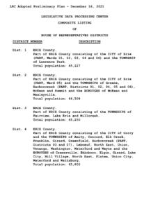
8 BYRNE State BASS RIVERSTATE FORESTWHARTON State FORESTATSION206563 EGGHARBORCITY539 CHATSWORTH73534536541 BERLINRED LIONEXIT50 GREAT BAYBATSTO5635327270 NKilometersMilesMap Scale11023405678910123451 Please RememberThe tra ils shown here are for hiking and cross-country skiing only. Short lengths of tra il may temporarily accumulate rainwater runoff. Ticks, chiggers, biting flies, and mosquitoes can be Jersey State Forests are carry-in / carry-out areas, so please take your trash with you. It is unlawful to remove any plants or non-game animals as well as any historic artifacts from State forest property. HELP PREVENT WILDFIRES! Based on USGSH ammonton , NJ 1:100 00 0 Topographic Map 1984 Trail Location Data: Franklin & Kathleen Pearce / Map Additions: Gilbert MikaThe 50-mile long Batona Trail derives its name from the words BAck TO NAture. It crosses vast tracts of New Jersey s Pinelands National Reserve. Batona TrailState of New JerseyDepartment of Environmental ProtectionDivision of Parks and ForestryState Park ServiceBass River State Forest762 Stage RoadTuckerton, NJ 08087(609) 296-1114 Brendan T.
9 Byrne State ForestPO Box 215 New Lisbon, NJ 08064(609) 726-1191 Wharton State Forest31 Batsto RoadHammonton, NJ 08037(609) 561-0024 (Batsto Office)(609) 268-0444 (Atsion Office)Keep Your Forest CleanThrough the Carry-In/Carry-Out Program you can help us keep your parks and forests clean and beautiful by carrying out the trash you carry in. Bags are provided at various locations. Thank you for your cooperation, and remember to recycle. Funding provided by the National Park Batona TrailThe Batona Trail began in 1961 when the Batona Hiking Club charted and cleared a Trail from Carpenter Spring in Brendan T. Byrne State Forest to Batsto in Wharton State Forest. Through the years the Trail was lengthened and now stretches for almost 50 miles, from Ong s Hat in Brendan T. Byrne State Forest, through Wharton State Forest and on to Bass River State Forest. The Trail is maintained jointly by the Batona Hiking Club, the Outdoor Club of South Jersey and the New Jersey State Park Service.
10 The Batona Trail traverses the Pinelands, a vast area of pine barrens habitat in South Jersey noted for its beautiful and unique flora and fauna, many species of which are found nowhere else in the world. An observant eye may catch orchids, white-tailed deer or a hawk around the next bend. Wild blueberries and huckleberries can be gathered by the handful in season. The route covers varied land features and forest types, meeting a number of streams and ponds along the way. Many areas rich in history also lie along the Trail , with names like Four Mile, Lebanon, Batsto and Martha, to remind us of the forgotten towns that once thrived here. The Trail is available for everyone to appreciate, but not abuse, the valuable and unique natural and cultural resources of the area. The Batona Trail was planned as a wilderness Trail , although rolling hills and an occasional sandy or wet area are the most severe tests this Trail will offer. The Trail can be walked from end to end by almost anyone, and it is prominently marked with pink blazes that are easily followed.