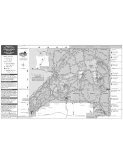
Transcription of BIKE & TRAILS MAP Visit ScottsdaleAZ.gov, search “preserve ...
1 McDowellSonoranPreserveMcDowellSonoranPr eserveStagecoach Pass RdCarefree HwyScottsdale Rd56th St60th St68th StAshler Hills DrLone Mountain RdDixileta DrWestland RdVia Dona Rd76th StDynamite Blvd56th St64th StPinnacle Vista DrJomax RdHayden RdHappy Valley RdMiller RdScottsdale RdPinnacle Peak RdWilliams DrDeer Valley RdGrayhawk DrThompson Peak Pkwy84th StPima RdDynamite BlvdPima RdHayden Rd79th StAlma School PkwyRio Verde DrJomax RdHappy Valley Rd136th StAlma School Rd93rd StLos Gatos DrScottsdale RdCentral Arizona Project CanalFrank Lloyd Wright BlvdParadise LnGreenway-Hayden LoopThunderbird RdSweetwater AveCactus Rd60th St64th StCholla RdShea BlvdGold Dust AveMountain View RdDoubletree Ranch RdEastwood LnMcCormick Ranch PkwyIndian Bend RdLincoln DrMcDonald DrMcKellips RdDesert Mountain PkwyLegend Trail PkwyDesert Hills DrPima RdLegacy Blvd94th StThompson Peak Pkwy98th St100th StFrank Lloyd Wright Blvd108th St104th StCholla St100th St96th StVia LindaMountain View RdVia Linda128th St120th St124th StCentral Arizona Project Canal130th St136th StShea BlvdBell RdPrincess DrLegacy BlvdHayden RdThunderbird Rd92nd St90th St94th St92nd St110 t h S tJackrabbit RdChaparral RdCamelback Rd68th StScottsdale Rd64th StOsborn RdThomas Rd68th St60th StOak StContinental DrCollege AveScottsdale RdMiller RdBelleview StHayden RdHayden RdGranite Reef RdRoosevelt StMcDowell RdOak StThomas RdOsborn RdIndian School RdCamelback RdChaparral RdVista DrJackrabbit RdMcDonald DrRose LnLincoln DrIndian Bend RdPima RdArizona CanalArizona Canal82nd StGranite Reef Rd86th St82nd StHayden Rd87th StGainey Ranch RdHayden RdMiller Rd84th StRedfield RdRaintree DrHayden RdNorthsight BlvdMcDowell RdVia De VenturaHayden RdPalisades Blvd145th WyEagle Ridge DrIndian School Rd70th
2 St Crosscut CanalXXXXXXXXXXXXXXXXXXXXXXXXXXXXXXXXXXX XXXXXXXXXXXXXXXXXXXXXXXXXXXXXXXXXXXXXXXX XXXXXXXXXXXXXXXXXXXXXXXXXXXXXXXXXXXXXXXX XXXXXXXXXXXXXXXXXXXXXXXXXXXXXXXXXXXXXXXX XXXXXXXXXXXXXACTIVE TRANSPORTATION MAPE ffective July 2019 FREE MAP!FOR DETAILED PRESERVE TRAIL MAPS: Visit , search preserve maps FOR THE MOST UP-TO-DATE CITYWIDE BIKEWAY, PATH AND TRAIL INFORMATION: Visit , search public amenities BIKE & TRAILS MAPNORTH OF FRANK LLOYD WRIGHT BLVDBICYCLES, SKATEBOARDS, MOTORIZED SKATEBOARDS AND MULTIUSE PATHSS cottsdale s Bicycle and Related Devices Ordinance (No. 4372) addresses operation and parking of bike-share and electric scooters. The ordinance makes the rules and expectations clear for the companies that own the devices and individuals who operate them. Go to , search bike share ordinance to review these rules. BICYCLE DETECTION AT INTERSECTIONSB icycle detection is used at signalized intersections to alert the signal system that a bicycle is approaching and will need to cross the intersection.
3 These intersections also offer extended crossing time for bicyclists. Look for these signs, as well as pavement markings, at various locations around scottsdale : Bike LaneBike RouteShared Use PathUnpaved Trail Paved ShoulderPreserve TrailCanal SystemCrossings (bridges, tunnels, underpasses or enhanced crosswalks) scottsdale EZ is a single, mobile-optimized system that lets you quickly report issues and provides the city with a consolidated tracking and reporting system. Using scottsdale EZ is just that easy! Visit on your desktop or mobile device, or search online for scottsdale EZ to find the application link Enter the request or issue in the search bar, select a top request or browse by category Choose an address related to the request, or use your device s GPS to pinpoint the location of the issue Provide details and submit a photo, if applicable Review your information and submit it City staff will get back to you to confirm they ve received your requestThe more accurate information you provide when submitting a request, the more quickly it can be assigned to staff and resolved.
4 Next time you notice something the city needs to take a look at or fix, don t hesitate scottsdale EZ makes it simple to report those issues and get them taken care of scottsdale Transportation Department 7447 E. Indian School Rd, Ste. 205 scottsdale , AZ 85251 SHARED USE PATH & TRAIL RESPONSIBILITIESS cottsdale s paths and TRAILS are designed for a variety of transportation modes. Keep path use safe and enjoyable for everyone by being courteous, sharing the path and following simple, common-sense rules. Motorized vehicles*, including ATVs and motorcycles, are prohibited on paths and TRAILS .*Class 1 and 2 e-bikes and stand-up electric mini-scooters are allowed on paved paths as of December 13, Horses When approaching a horse, speak in a soft voice to alert the horse and rider of your presence. Then move slowly while Your Pets Keep pets on a leash, and clean up after at Night Equip your bicycle with a headlight, rear light and reflectors for low light a Helmet Adults are not required by law to wear a helmet, but it is a good idea to always protect your head when Paths Do not enter paths that are under Use Earphones are not recommended when Bicyclists yield to pedestrians.
5 All users yield to equestrians. Use reasonable Follow the same rules as pedestrians. xxxKeep to the Right Stay to the right unless passing or turning. Move to the right when stopping as Look both ways. Yield to through traffic at Bicyclists should use their horn or bell when approaching and passing Nature Do not disturb wildlife. Stay on the path. Do not collect plant materials. 1 MILEAPPROXIMATE SCALEN otice: This document is provided for general information purpose only. The city of scottsdale assumes no responsibility arising from the use of the information in this document. The city of scottsdale does not warrant its accuracy, completeness, or suitability for any particular purpose. It should not be relied upon without field Pass RdCarefree HwyScottsdale Rd56th St60th St68th StAshler Hills DrLone Mountain RdDixileta DrWestland RdVia Dona Rd76th StDynamite Blvd56th St64th StPinnacle Vista DrJomax RdHayden RdHappy Valley RdMiller RdScottsdale RdPinnacle Peak RdWilliams DrDeer Valley RdGrayhawk DrThompson Peak Pkwy84th StPima RdDynamite BlvdPima RdHayden Rd79th StAlma School PkwyRio Verde DrJomax RdHappy Valley Rd136th StAlma School Rd93rd StLos Gatos DrScottsdale RdCentral Arizona Project CanalFrank Lloyd Wright BlvdParadise LnGreenway-Hayden LoopThunderbird RdSweetwater AveCactus Rd60th St64th StCholla RdShea BlvdGold Dust AveMountain View RdDoubletree Ranch RdEastwood LnMcCormick Ranch PkwyIndian Bend RdLincoln DrMcDonald DrMcKellips RdDesert Mountain PkwyLegend Trail PkwyDesert Hills DrPima RdLegacy Blvd94th StThompson Peak Pkwy98th St100th
6 StFrank Lloyd Wright Blvd108th St104th StCholla St100th St96th StVia LindaMountain View RdVia Linda128th St120th St124th StCentral Arizona Project Canal130th St136th StShea BlvdBell RdPrincess DrLegacy BlvdHayden RdThunderbird Rd92nd St90th St94th St92nd St110 t h S tJackrabbit RdChaparral RdCamelback Rd68th StScottsdale Rd64th StOsborn RdThomas Rd68th St60th StOak StContinental DrCollege AveScottsdale RdMiller RdBelleview StHayden RdHayden RdGranite Reef RdRoosevelt StMcDowell RdOak StThomas RdOsborn RdIndian School RdCamelback RdChaparral RdVista DrJackrabbit RdMcDonald DrRose LnLincoln DrIndian Bend RdPima RdArizona CanalArizona Canal82nd StGranite Reef Rd86th St82nd StHayden Rd87th StGainey Ranch RdHayden RdMiller Rd84th StRedfield RdRaintree DrHayden RdNorthsight BlvdMcDowell RdVia De VenturaHayden RdPalisades Blvd145th WyEagle Ridge DrIndian School Rd70th St Crosscut CanalXXXXXXXXXXXXXXXXXXXXXXXXXXXXXXXXXXX XXXXXXXXXXXXXXXXXXXXXXXXXXXXXXXXXXXXXXXX XXXXXXXXXXXXXXXXXXXXXXXXXXXXXXXXXXXXXXXX XXXXXXXXXXXXXXXXXXXXXXXXXXXXXXXXXXXXXXXX XXXXXXXXXXXXXAPPROXIMATE SCALE1 MILEN otice: This document is provided for general information purpose only.
7 The city of scottsdale assumes no responsibility arising from the use of the information in this document. The city of scottsdale does not warrant its accuracy, completeness, or suitability for any particular purpose. It should not be relied upon without field OLD TOWN ON THE MOUNTAIN VISTA BIKE ROUTE The Mountain Vista Bike Route is a mile loop that begins and ends at Main Street and Brown Avenue at the famous Banyan Tree. Follow green bike route signs to two more informative stops where mountain views are framed with interpretive panels that tell stories of the mountains on display. The frame that views the mcdowell Mountains is located along the south bank of the Arizona Canal between the Marshall Way and Soleri bridges. The Camelback Mountain View frame is located at 68th Street and the Arizona VISTA ROUTE12368th St69th StScottsdale RdIndian School RdGoldwater Blvd5th AveStetson DrMarshall Way5th Ave3rd Ave4th Ave1st AveMain St1st S t2nd StBrown AveROUTE STOPS1.
8 The Banyan Tree2. Camelback Mountain View3. mcdowell Mountains ViewON-STREET BIKEWAYS SHARE THE ROADBe sure to ride defensively, prepare for the unexpected and plan an alternate maneuver to avoid conflict. Rules alone do not always protect bicyclists from injury. Stay alert, make yourself visible and ride Arizona Revised Statutes - TITLE 28 TRANSPORTATION - ARTICLE 11 OPERATION OF BICYCLES28-811. Parent and guardian responsibility; applicability of article 28-812. Applicability of traffic laws to bicycle riders Riding on bicycles Clinging to Riding on roadways and bicycle paths; prohibition of motor vehicle traffic on bike paths Carrying article on bicycles Bicycle equipment Bicycle safety fundObey Traffic Signals & Signs Like a vehicle, bicyclists must obey all the rules of the on the Right Ride on the right with the flow of Appropriate Lanes To proceed straight, move into the through lane of Car Doors Stay one car-door length away from parked Hand Signals Check over your shoulder, and turn when safe to do Lights at Night Law requires a white headlight and rear reflector at night.
9 Adding a red rear light is even OWScan the Road Behind Check behind you regularly, or use a a Helmet Adults are not required by law to wear a helmet, but it is a good idea to always protect your head when Person Per Bike Riding double is only permitted with child carriers or tandem Left: Two Options Make a left turn like a vehicle by looking over your shoulder, signaling and moving into the left turn lane when it s may also make a left turn by going to the far side of the intersection, turning your bike and using the roadway or Eye Contact Confirm that you are Courteous Share the road and the YOUR BIKE ON THE scottsdale TROLLEYS cottsdale s free trolley system links residents and visitors to entertainment, restaurants, shopping, schools, parks and health services. Riders can transfer between four trolley routes and the regional transit system. To plan your trip, Visit To request a map or learn more, Visit driver before loading your a nice daySqueeze handle and pull down bike in rack support arm and pull over tire to assumes all liability for loading, securing, unloading, theft or damage of DETECTION AT INTERSECTIONSB icycle detection is used at signalized intersections to alert the signal system that a bicycle is approaching and will need to cross the intersection.
10 These intersections also offer extended crossing time for for these signs, as well as pavement markings, at various locations around scottsdale : Bike LaneBike RouteShared Use PathUnpaved Trail Paved ShoulderPreserve TrailCanal SystemCrossings (bridges, tunnels, underpasses or enhanced crosswalks)FOR DETAILED PRESERVE TRAIL MAPS: Visit , search preserve maps FOR THE MOST UP-TO-DATE CITYWIDE BIKEWAY, PATH AND TRAIL INFORMATION: Visit , search public amenities BIKE & TRAILS MAPSOUTH OF FRANK LLOYD WRIGHT BLVD