Transcription of BLACK HILLS TRAILS SYSTEM TRAIL DIRECTORY
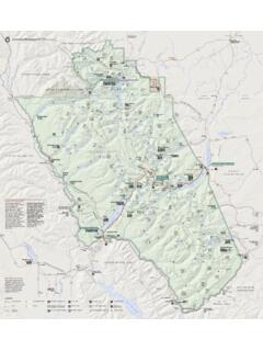
1 !!!!!!!!!!!!!!!!!!!!!!!!!!!!")W")W")W")W ")W")W!.#!.#!.#!.#!(!(!(Big Hill X-C Ski TrailsEagle CliffX-C Ski TrailsBeaver CreekX-C Ski TrailsWinter Wildlife RangeMinimalGroomingSpearfi sh Canyon LodgeRecreati onal Springs ResortBuckhorn BarMallo Mote lMt. Meadow StoreCarste n CottagesCuste r Crossing CampgroundBlack HILLS Off-Road Renta lsGolden HILLS LodgeCement Ridge LookoutCuster Peak LotBig Hill LotTerry Peak Lot & Ski AreaEndSouth Ditch Creek LotGrand Vista PassClinton OverlookHill Top LotFlag mountain Lookout!1!1!5!2F!6!7A!3B!2B!1S!3A!12!9!7 C!2K!8!7!13!4!2P!5T!3!3C!5A!11!2!12B!5C! 5W!2C!2A!4 AMad Mounta in Adventu resSteel Wheel Trading PostPowder House PassTrailshead LodgeWhite ta il Creek ResortRoughlock FallsBlack Fox!5 LNOTICET here are a few areas closed to snowmobiling, including active logging operations, winter wildlife range, plowed roadways, developed cross-country ski areas and posted private land.
2 Be aware that numerous parcels of private property (white) are interspersed within the BLACK HILLS National Forest (green). PLEASE respect private property owners. No Trespassing means NO SNOWMOBILING. If you choose to trespass, you could be arrested; but you could also cause us to lose other valuable riding areas. Most of these areas are depicted on an annual Forest Service Snowmobile TRAIL map with vehicle SNOWMOBILE USE ONLYBLACK HILLS TRAILS SYSTEM350 MILESThe BLACK HILLS Snowmobile TRAILS SYSTEM is maintained through a cooperative effort of South Dakota Game, Fish and Parks, the USDA Forest Service, Bureau of Land Management, Barrick Mining Co., Wharf Resources, Inc. and numerous private landowners. The million-acre BLACK HILLS National Forest offers unlimited off- TRAIL riding in addition to the 350 miles of TRAILS groomed by the South Dakota Snowmobile Program.
3 Forty miles of the SYSTEM are made available through a cooperative agreement with the Wyoming Division of State Parks and Historic Sites. The official season is from December 15-March encountering elk, deer or other wildlife, please stay on your snowmobile and keep moving. Limited contact reduces the impact on wild animals during the critical winter season when food supplies are at the lowest and animals are most vulnerable to TRAILS depicted on this map may be rerouted or closed for safety, maintenance or any other reason without prior HILLS TRAILS SYSTEMTRAIL CONDITIONSS nowmobile TRAIL conditions and live TRAIL cameras are available online at and via our mobile app: SDGFP Outdoors. TRAIL conditions are also posted to Twitter accounts dedicated to both the BLACK HILLS and the East River TRAILS ( and ).
4 TRAVEL INFORMATION Go to , call ( ) to request a South Dakota Vacation Guide and seasonal information, or write to: South Dakota Department of Tourism 711 E. Wells Ave. Pierre, SD 57501-3369 For emergencies, dial 911. SITE LOCATION FACILITIES BLACK HILLS Vacations Box 523, Deadwood, SD 57732 Snowmobile rentals, lodging, food | reservation service Hours of operation: M-F , Sat-Sun BLACK HILLS Inn TRAIL #7; mi. S of Deadwood Main St. Indoor pool and hot tub & Suites on Hwy 385. Continental Breakfast | Open Daily BLACK HILLS Off-Road TRAIL #7; 6 mi. S of Deadwood on Hwy 385. n n n n n n n n n n n n Rentals Located at Steel Wheel Campground.
5 Open Daily | Blackstone Lodge & TRAIL #5L, N of Lead on Hwy 14A & Hwy 85 Suites Open 24/7 Buckhorn Bar & Grill TRAIL #3; 25380 N Hwy 85. Open , Carsten Cottages 21981 N Rochford Rd., Lead. Open 24/7 Custer Crossing TRAIL #7C; 15 miles S of Deadwood on Hwy 385. Campground Open , , closed Tuesdays, Thanksgiving and Christmas Deadwood Comfort Inn TRAIL #7; 225 Cliff St., 1 mi. S of Main St. & Suites Deadwood on Hwy 85 Lounge, pool/hot tub, guest laundry | gaming, kids arcade, pool tables, darts Open 24/7 Deadwood Gulch TRAIL #7; 1 mi.
6 S of Deadwood Main St. Gaming Resort on Hwy 85. Casino, indoor hot tub | Packages available Open 24/7 Deadwood Super 8 TRAIL #7; 196 Cliff St., Deadwood. | Open 24/7 Golden HILLS Lodge TRAIL #5L; Intersection of Hwy 14A and Hwy 85 in Lead. Open 24/7 Lewie s Saloon TRAIL #5; .25 mi. from Terry Peak turn-off and Eatery on Hwy 85-14A. Open Tues-Sun, Mad mountain TRAIL #5; 6 mi. S of Lead on Hwy 85. Adventures | Open daily Mallo Camp & Motel TRAIL #11; 478 Mallo Rd mi. E of 4 Corners on City Rd 810. 8 camper sites, shower house, dogs welcome in camping area Open daily. Group rates available Mt.
7 Meadow Store TRAIL #2; 14 mi. NW of Hill City off Deerfield Rd and Campground, LLC. 11321 Gillette Prairie Rd. Open daily Mystic HILLS Hideaway TRAIL #7; 10 mi. S of Deadwood on Hwy 385, & TRAILS Rentals then .5 mi. W. on FS Rd 216. Restaurant open: Wed-Sun, Snowmobile rentals: open daily 8 :30 Ponderosa Pines Inn TRAIL #5L, North Lead on Hwy 14A, Lead. and Cabins Open , Recreational Springs TRAIL #5; 6 mi. S of Lead on Hwy 85. n n n n n n n n n n n n Resort Open , Fri-Sat. Roundhouse Liquors TRAIL #5L; Intersection of Hwy14A & Hwy 85.
8 In Lead. Open daily Spearfish Canyon TRAIL #4; 14 mi. S of Spearfish on Hwy 14A n n n n n n n n n n n n Lodge in Spearfish Canyon. Open 24/7 | Sports Center: Latch String: Southside Service End of TRAIL #7, Deadwood Open M-F , Sat. , Closed Sun. 24 hr. pay at the pump Steel Wheel Cabins & TRAIL #7; mi. S of Deadwood on Hwy 385. Trading Post Trading Post: M-Sat. , Sun. Terry Peak Ski Area End of TRAIL #5T; 21120 Stewart Slope Rd. Lead Open daily Trailshead Lodge TRAIL #1; 21 miles SW of Lead on Hwy 85. n n n n n n n n n n n n Open M-Sat Sun Whitetail Creek Resort TRAIL #5W; 2 mi.
9 SW of Lead on Hwy 14A/85. Open daily Big Hill Lot TRAIL #1; 8 mi. SW of Spearfish on FSR 134. Chains or 4WD advised. Custer Peak Lot TRAIL #7; 11 mi. S of Deadwood on Hwy 385 and .5 mi. west on FSR 216. Hill Top Lot TRAIL #2; 15 mi. NW of Hill City on Deefield Rd. Dumont Lot TRAIL #7; 4 mi. SW of Lead on Hwy 85 and 6 mi. S on Rochford Rd. Recreational Springs Lot TRAIL #5; 6 mi. S of Lead on Hwy 85 South Ditch Creek Lot TRAIL #2S; Turn W off of Hwy 385 by Heritage Village, .6 mi. W on Medicine Mtn. Rd., mi. W on Custer Limestone Rd., .5 N on Saginaw Rd., mi. W on Elliott Rd., mi. N on Ditch Creek Rd. Spearfish Canyon Lot TRAIL #4; W of Spearfish Canyon Lodge. Steel Wheel Cabins & TRAIL #7; mi.
10 S of Deadwood on Hwy 385. Trading Post Terry Peak Lot TRAIL #5T; mi. Nevada Gulch Rd., .6 mi. on Stewart Slope Rd. Trailshead Lot TRAILS #1 21 mi. S of Lead on left side of Hwy 85. BLACK Fox On TRAIL #2; portable warming shelter Warming Shelter located at scenic BLACK Fox Campground. Cement Ridge On TRAIL #3C; lower level of an active fire Lookout lookout serves as a wind shelter with spectacular view of four-state area. Clinton On TRAIL #2B; scenic vista overlooking Overlook Gillette Prairie. Flag mountain On TRAIL #2F; spectacular vista overlooking Lookout Reynolds Prairie and surrounding area. Grand Vista On TRAIL #2P; spectacular vista of the Needles Pass and surrounding area.