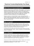
Transcription of California SNO-PARK Sites
1 MarysvilleGrass ValleyAuburnTruckeeRenoCarson CityMODESTOJ acksonAngelsCampMercedOakhurstMammoth LakesI-80SR 89SR 89SR 88SR 88SR 4SR 108SR 120I-80SR 108SR 4US 50SR 120 FRESNOSR 89SR 49US 395US 395SR 49SR 49SR 99I-5US 50SR 41SR 16 NEVADACALIFORNIA1231112131318SR 168 BassettsSierravilleSierra CityBoreal Ski AreaTahoe CityLake TahoeMeyersStrawberryCarson PassBear ValleyLake AlpinePinecrestHuntingtonLakeShaverLakeS R 991010 SACRAMENTOS onoraSTOCKTONP lacerville4567891415161714151617 LakeshoreBig CreekPine RidgeDinkey CreekHuntington LakeShaver LakeShaverLakeHuntington LakeSR 168SR 89SR 89SR 89SR 50SR 8856789 Camp RichardsonLake TahoeSouth Lake TahoeMeyersEcho SummitLuther PassPicketts JunctionCarsonPassTwin BridgesKirkwood4 NDay Use Permits: $ | Season Permits: $ | | SNO-PARK Sites1. YUBA PASS Located on the south side of Highway 49 at Yuba Pass.
2 Contact: tahoe National Forest, Sierraville Ranger District - (530) 994-3401. GPS: 39 37 N, 120 29 W2. DONNER SUMMIT Located on the south side of I-80 at the Castle Peak exit beyond Boreal Inn. Contact: tahoe National Forest, Truckee Ranger District - (530) 587-3558. GPS: 39 20 N, 120 20 W No snowmobiling3. BLACKWOOD CANYON Located on the west side of Highway 89, three miles south of tahoe City. Contact: Lake tahoe basin Management Unit - (530) 543-2600. GPS: 39 6 N, 120 9 W4. TAYLOR CREEK Located on the south side of Highway 89, just north of Camp Richardson Road. Contact: Lake tahoe basin Management Unit - (530) 543-2600. GPS: 38 55 N, 120 3 W No snowmobiling5. ECHO LAKE Located on the north side of Highway 50 at Echo Lake Road. Contact: Eldorado National Forest, Placerville Ranger District - (530) 644-2324.
3 GPS: 38 49 N, 120 2 W No snowmobiling6. HOPE VALLEY Located on the south side of Highway 88 at Blue Lakes Road. Contact: Humboldt-Toiyabe National Forest, Carson Ranger District - (775) 882-2766. GPS: 3 8 4 4 5 N, 119 5 6 2 3 . 3 4 W7. CARSON PASS Located on the south side of Highway 88 near Carson Pass. Contact: Eldorado National Forest, Amador Ranger District - (209) 295-4251. GPS: 3 8 41 N, 119 59 W No snowmobiling8. MEISS MEADOW Located on the north side of Highway 88 near Carson Pass. Contact: Eldorado National Forest, Amador Ranger District - (209) 295-4251. GPS: 3 8 41 4 6. 81 N, 119 59 W No snowmobiling9. IRON MOUNTAIN Located on the north side of Highway 88 at Mormon-Emigrant Trail Road. Contact: Eldorado National Forest, Amador Ranger District - (209) 295-4251. GPS: 3 8 37 4 N, 120 12 W10.
4 ROUND VALLEY Located on Highway 207, just north of Highway 4. Contact: Stanislaus National Forest, Calaveras Ranger District - (209) 795-1381. GPS: 38 29 N, 120 1 W No snowmobiling11. LAKE ALPINE Located at the winter closure gate on Highway 4. Contact: Stanislaus National Forest, Calaveras Ranger District - (209) 795-1381. GPS: 38 28 N, 120 1 W12. SPICER Located on the south side of Highway 4 at Spicer Road. Contact: Stanislaus National Forest, Calaveras Ranger District - (209) 795-1381. GPS: 38 25 N, 120 4 W13. HIGHWAY 108 Located at the winter closure gate on Highway 108, east of Strawberry. Contact: Stanislaus National Forest, Summit Ranger District - (209) 965-3434. GPS: 38 16 N, 119 5 9 3 0. 31 W14. TAMAR ACK Located on the south side of Highway 168, east of Shaver Lake. Contact: Sierra National Forest, High Sierra Ranger District - (559) 855-5355.
5 GPS: 37 9 N, 119 12 W15. COYOTE Located on the north side of Highway 168, east of Shaver Lake. Contact: Sierra National Forest, High Sierra Ranger District - (559) 855-5355. GPS: 37 10 N, 119 12 W No snowmobiling16. EAST WOOD Located on the east side of Highway 168 at Huntington Lake Road. Contact: Sierra National Forest, High Sierra Ranger District - (559) 855-5355. GPS: 37 15 N, 119 9 3 W17. HUNTINGTON LAKE Located on the west side of Huntington Lake Road, three miles from Eastwood SNO-PARK . Contact: Sierra National Forest, High Sierra Ranger District - (559) 855-5355. GPS: 37 15 N, 119 10 W18. ROCK CREEK Located on the west side of Highway 395 at Rock Creek Road. Contact: Inyo National Forest, White Mountain Ranger District - (760) 873-2500. GPS: 37 29 N, 118 43 W No snowmobilingCross-country SkiingSnowmobilingSnow PlayDog SleddingRECOMMENDED ACTIVITIES