Transcription of Chapter 12 The Urban and Rural Classifications - Census.gov
1 The Bureau of the Census defines Urban as comprising all territory, popu-lation, and housing units located in urbanized areas and in places of 2,500 or more inhabitants outside of UAs. The term urbanrefers to both kinds of geographic entities. The terms Urban , urbanized area, and ruralare theCensus Bureau s definitions; other Federal agencies, State agencies, localofficials, and private groups may use these same terms to identify areas based on different criteria. Urbanized Areas (UAs)A UA is a continuously built-up area with a population of 50,000 or comprises one or more places central place(s) and the adjacent densely settled surrounding area Urban fringe consisting of other places and nonplace territory. Urban Places Outside of UAs Outside of UAs, an Urban place is any incorporated place or census des-ignated place (CDP) with at least 2,500 inhabitants. A CDP is a densely settled population center that has a name and community identity, and is not part of any incorporated place (see Chapter 9, Places ).
2 Rural Places and TerritoryTerritory, population , and housing units that the Census Bureau doesnot classify as Urban are classified as instance, a Rural place is any incorporated place or CDP with fewer than 2,500 inhabitants that islocated outside of a UA. A place is either entirely Urban or entirely Rural ,except for those designated as an extended city. Extended CitiesAn extended city is an incorporated place that contains large expanses ofsparsely populated territory for which the Census Bureau provides sepa-rate Urban and Rural population counts and land area figures. Urban and Rural Classifications 12-1 The Urban and Rural ClassificationsChapter 12 Components of the Urban and Rural Classifications12-2 Urban and Rural ClassificationsThe Census Bureau defines UAs and extended cities for statistical purposesonly; that is, for the purpose of presenting its data. Although some othergeographic statistical entities, such as census tracts and CDPs, originatefrom agreement and cooperative action with local governmental officialsand other outside groups, the development and implementation of cri-teria for defining and delineating UAs and extended cities has been largelythe responsibility of the Census Bureau from the inception of the Chapter discusses (1) the Census Bureau s criteria for classifying areasas Urban (with an emphasis on the definition of UAs and extended cities),(2) the procedures used to establish UAs and update their boundaries,and (3) the relationship of UAs to other geographic entities.
3 The CensusBureau applies the same Urban and Rural definitions to all parts of theUnited States, Puerto Rico, and the Outlying Areas. Puerto Rico has bothUAs and Urban places outside of UAs; the Outlying Areas AmericanSamoa, Guam, the Northern Mariana Islands, Palau, and the Virgin Islandsof the United States have only Urban Definitions of UrbanStatistics by Urban and Rural categories have figured in decennial censuspublications for over a In the censuses of 1880, 1890, and 1900,the Census Office (predecessor of the Census Bureau) published tablesbased on minimum sizes of 8,000, 4,000, and 2,500 inhabitants; the latterfigure was officially adopted for the 1910 census. In the decennial cen-suses from 1910 through 1940, Urban comprised all territory, people,and housing units in incorporated places of 2,500 or more. In addition,some areas usually minor civil divisions (MCDs)2 were classified asurban under special rules relating to population size and density.
4 Thisdefinition of Urban was not adequate because (1) it excluded many large,densely settled population concentrations merely because they werenot part of any incorporated place, and (2) it continued to classify manylarge, densely built-up areas as Rural in spite of the special rules thatUrban and Rural Classifications 12-3permitted classification of some MCDs as Urban . Something more thanplace/MCD size was needed to define Urban area and of the UA Concept From 1950 Through 1990To improve its measure of Urban territory, population , and housing unitsfor the 1950 census, the Census Bureau introduced two new types of geo-graphic units, the UA and the This step resulted in major changesto the Urban and Rural Classifications . The introduction of CDPs meantthat densely settled population centers without legal status were recog-nized as places, and classified as Urban if they had at least 2,500 identification and delineation of UAs made it possible to include asurban many densely built-up areas that had previously been classifiedrural because they were not part of any place.
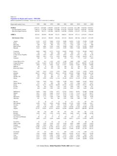
5 By using these new geo-graphic entities UAs and CDPs the Census Bureau improved its sep-aration of the Urban and Rural population . Outside of UAs, the CensusBureau continued to classify a place (whether an incorporated place ora CDP) as Urban if its population was at least 2, 12-1 summarizes important elements of the UA definitional criteriaas they have developed through the period 1950 through 1990. Many ele-ments of the criteria have remained largely unchanged. The density crite-rion of at least 1,000 people per square mile has remained the same sinceit was adopted for the 1960 census. The provision allowing the inclusionof distinctly Urban land uses has been part of the UA criteria since it wasadopted for the 1950 census. Measures of density and concentration con-tinue as the basis for including places in the Urban fringe zone. With theexception of extended cities, entire places are still, in most instances, themajor geographic building blocks of a recent years, significant revisions to the UA criteria have included therecognition of extended cities and more liberal criteria for central placesand CDPs.
6 Extended cities, identified starting with the 1970 census, betterdefine the extent of Urban and Rural territory (area), but have very littleeffect on the Urban and Rural population and housing unit counts at the12-4 Urban and Rural ClassificationsTable 12-1. Development of UA Criteria From 1950 Through 19901950 Central place requirementIncorporated place population of 50,000 or more (1940 census count)Method of boundary delineationPopulation estimates, precensus surveys, aerial photographyDensity requirementAt least 500 dwelling units (approximately 2,000 people per square mile)Place population in Urban fringe Incorporated places with at least 2,500 people; no CDPs were included Smaller incorporated places with a concentration of 100 or more dwelling unitswhose density was at least 500 dwelling units per square mileOther featuresExclaves of discontiguous nonplace territory within 11/2 miles and connectedby roadNumber of UAsA total of 1571960 Central place requirement Incorporated place population of 50,000 or more using current census counts Twin cities rule (two contiguous incorporated places with a combined populationof at least 50,000, the smaller of which must have at least 15,000)Method of boundary delineationCensus results, small enumeration districts (EDs)Density requirementAt least 1,000 people per square milePlace population in Urban fringeAt least 2,500 people.
7 CDPs if at least 10,000 people (except New England)Other features MCDs in New England, New Jersey, and Pennsylvania with at least 25,000 inhabitantsor a population density of at least 1,500 people per square mile and a minimumtotal population of 2,500 became Urban by special rule; this rule applied only to the1960 census. Inclusion of indentations/enclaves First UAs in Hawaii and Puerto RicoNumber of UAsA total of 2131970 Central place requirement Incorporated place population of 50,000 or more using current census counts An incorporated city of 25,000 or greater population could qualify as a centralplace if it could combine with contiguous places of any size (but with a density ofat least 1,000 people per square mile) to obtain a total population of at least 50, of boundary delineationBlocks (mail areas), small EDs (non-mail areas) Urban and Rural Classifications 12-5 Table 12-1. (cont.)Density requirementAt least 1,000 people per square milePlace population in Urban fringe Incorporated places with at least 2,500 people CDPs if at least 5,000 people (except New England) Some CDPs if at least 1,000 people this lower threshold applied if an incorporatedplace of at least 25,000 inhabitants could join with contiguous places of any size (anda density of at least 1,000 people per square mile) to reach a total population of atleast 50, featuresIntroduction of extended citiesNumber of UAsA total of 2751980 Central place requirementIncorporated place (any size)
8 Within a densely settled area of at least 50,000 populationMethod of boundary delineationBlocks, small EDs in certain situationsDensity requirementAt least 1,000 people per square milePlace population in Urban fringeIncorporated places of at least 2,500 peopleOther features Whole-town CDPs (MCDs in New England, Michigan, New Jersey, New York,Pennsylvania, and Wisconsin having at least 95 percent of their population and atleast 80 percent of their land area qualifying for inclusion in the UA were includedin their entirety in the UA applicable only to the 1980 census). First CDPs in New England UAsNumber of UAsA total of 3661990 Central place requirementIncorporated place of any size within a densely settled area of at least 50,000 population ;CDP of any size permitted as central placeMethod of boundary delineationBlocks exclusivelyDensity requirementAt least 1,000 people per square milePlace population in Urban fringeWhole place test, minimum CDP population of generally 2,500 Other featuresIntercensal UAs, new titling provisions for UAsNumber of UAsA total of 40512-6 Urban and Rural Classificationsnational and State levels (for some individual counties and UAs the effectshave been more evident).
9 Since the 1970 census, changes in the minimum size criterion to qualify asa central place have permitted the delineation of UAs around smaller pop-ulation centers. For 1990, there was no size requirement for a central inclusion of CDPs in the Urban fringe, which began in 1960, and theincreasing liberalization of the minimum population size requirements forCDPs, mark a continuing local involvement and interest in these geographicentities. In 1980, the Census Bureau delineated CDPs in the UAs of the sixNew England States (no CDPs had been delineated in New England UAspreviously). For 1990, the change of the designation central city to centralplace further underlined the importance of CDPs in UA for the 1990 CensusBefore each decennial census, the Census Bureau reviews the criteria fordelineating UAs and extended cities. As a result of this review, the CensusBureau historically has proposed improvements to assure that these enti-ties consistently measure the Nation s settlement pattern.
10 The CensusBureau then publishes the proposed criteria in the Federal Register andsolicits comments from the data-using public. Where necessary, furtherrevisions are made before the final criteria are published. For 1990, thefollowing major changes were made: Through the 1980 census, the urbanized area delineation process hadtaken place only once every decade, at the time of the decennial in 1986, the Census Bureau allowed the delineation of newUAs on the basis of a special census taken in the intercensal areas (Davis, CA, and Merced, CA) qualified as UAs on the basis ofa special census; two others (Bowling Green, KY, and Elizabethtown-Radcliffe, KY) did not. Areas that had been UAs in a previous census were not automaticallygrandfathered if their 1990 population fell below 50,000. As a result,two areas that had been UAs in 1980 (Danville, IL, and Enid, OK) wereno longer UAs in and Rural Classifications 12-7 The whole place test improved the rules for inclusion of incorporatedplaces and CDPs in the Urban fringe.