Transcription of Chapter 6 Stratigraphy, Lithology, and Hydraulic ...
1 129 Chapter 6 Stratigraphy, Lithology, and Hydraulic Properties of the Chicot and Evangeline Aquifers in the LSWP Study Area, Central Texas Coast Steve C. Young1, Paul R. Knox2, Trevor Budge1, Van Kelley, , Neil Deeds3, William E. Galloway4, and Ernest T. Baker1 Introduction A numerical groundwater model of the Chicot and Evangeline aquifers is under construction for the Lower Colorado River Authority-San Antonio Water System Water Project (LSWP) in Colorado, Wharton, and Matagorda counties along the Texas Gulf Coast, south of Houston. Because the Hydraulic properties of the aquifer should correlate with lithology and depositional origin, a study defining the comprising formations, their juxtapositional relationships, dominant lithologies, and depositional environments was undertaken. Previous geologic and hydrogeologic studies and numerical models of the Gulf Coast aquifer in the study area are summarized by Young and Kelley (2005).
2 These studies, though of varying scope and differing geographic area and stratigraphic interval, have established a general framework for the Gulf Coast aquifer , but they can differ appreciably in their details. Our study uses the Chicot formations established by Baker (1979) and the formation ages established by BEG (1992). This Gulf Coast aquifer framework includes the shallower Chicot aquifer , which is composed of the Pleistocene-age Lissie Formation and Pliocene-age Willis Formation, and the deeper Evangeline aquifer , which includes the upper and lower Goliad (Miocene-age) formations. The goal of this study (Young and Kelly, 2005) is to create a unified and well-documented geologic and hydrogeologic framework for the Chicot and Evangeline aquifers defined at the scale of the geologic formations that compose them.
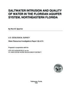
3 1 URS Corporation 2 Baer Engineering and Environmental Services, Incorporated 3 INTERA Incorporated 4 Institute for Geophysics, The University of Texas at Austin 130 Methods Formation-level stratigraphic correlations were tied to outcrop formations from the Geologic Map of Texas (BEG, 1992). Subsurface stratigraphic, lithologic, and depositional facies interpretations relied upon geophysical logs from a total of 622 wells (Figure 6-1), which include 300 logs analyzed by Dutton and Richter (1990). A series of six cross-sections through selected wells, along with additional wells between sections (140 wells total), were used to establish the subsurface stratigraphic framework and interpret depositional facies. Micropaleontology-based geologic age boundaries from previous cross-section studies (Dodge and Posey, 1981; Morton and others, 1985) were correlated to study wells in order to establish subsurface formational boundaries for Miocene-age formations, including the contact of the top of the Miocene and the base of Pliocene-age strata.
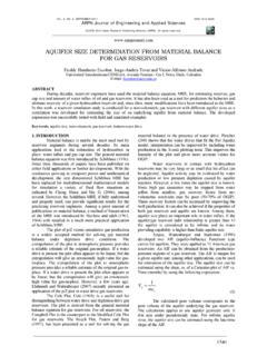
4 A depth to the base of Pleistocene-age sediments in the subsurface was estimated from work by Guevara-Sanchez (1974), also supported by micropaleontology. A series of 11 geologic timelines from the top of the Lissie Formation to the base of the Goliad Formation were correlated throughout the 140 logs by recognition of laterally persistent changes in vertical lithology and facies profiles in logs. Figure 6-1. Location of geophysical logs and the six cross-sections. 131 Stratigraphy, Lithology, and Depositional Facies The four major formations studied descend from the surface outcrop at the northern fringe of the study area into the subsurface to the southeast (toward the coast), as exhibited by cross-section 50 in Figure 6-2. An area of increased dip occurs along a zone in the northwest part of the study area, in central Colorado County, and is sub-parallel to the coast.
5 Updip (northwest) of this zone, both the Lissie and Willis formations thin abruptly as they come up to the surface, each exhibiting mild erosional truncation of the respectively underlying formation. At outcrop, these two formations exist over large areas, most likely as a thin veneer of gravel as little as ten feet thick. The boundary between the upper and lower Goliad formations appears to be mildly erosional over much of the subsurface area and an abrupt increase in sand content occurs above this boundary. The aquifer boundaries as interpreted in the Source Water Assessment and Protection (SWAP) Program are also plotted and show the base of the SWAP Chicot aquifer to be significantly above the base of the Willis Formation (LSWP base Chicot), by as much as 500 feet in many areas. Across much the study area the SWAP data places the bottom of the Chicot aquifer much closer to the bottom of the Lissie Formation than the Willis Formation.
6 Cross-Section 50-4000-3500-3000-2500-2000-1500-1000-50 0050005000010000015000020000025000030000 0350000400000450000500000 Distance Downdip, ftElevation, ft mslUSGS TopographySWAP Chicot BottomSWAP Evangeline BottomColorado CountyWharton CountyMatagorda CountyBeaumontLissieW illisUpper GoliadLower Goliad Figure 6-2. Surfaces for five geological formations along cross-section 50. Data from the lithologic analyses performed by Dutton and Richter (1990) were significantly lower in percent sand class, and absolute values were not used in the mapping process. Instead, their relative values were used to guide sand trends in areas where four-fold data were sparse. The Lissie and Willis formations contain the highest sand-class percent material (each averaging about 65 percent) across the study area, with the greatest sand content in the northeast part of the study area.
7 The upper Goliad Formation is approximately ten percent lower in sand-class material (average across the study area) than the Lissie and Willis formations, with sand dominating the north and east parts of the area. Calculated sand-class values for the lower Goliad 132 Formation are about seven percent lower than those for the upper Goliad Formation, with a series of distinctly sandier areas trending northwest to southeast across the study area. The differences in the sand-class distributions produced for the Willis and upper Goliad formations are shown in Figure 6-3. The sand-class data provide potentially pertinent information regarding the discrepancy between the base of the Chicot aquifer in this study and that in the SWAP dataset. Sand-class values were tabulated for the Chicot and Evangeline aquifers using the aquifer boundaries from the SWAP dataset and those from this study (Table 6-1).
8 As noted by Baker (1979), Jorgensen (1975), and Carr and others (1985), the Chicot aquifer is conceptually distinguished from the Evangeline aquifer by its distinctly greater Hydraulic conductivity, which equates to greater sand percent. Table 6-1 was created to help quantify the difference in the sand-class distributions between the Chicot and Evangeline aquifers in order to provide a framework for deciding whether or not our representation of the boundary of the base of the Chicot aquifer is reasonable. In Table 6-1, the LSWP-SWAP interval is the aquifer volume sandwiched between the two approximations of the base of the Chicot aquifer across the study area. Logs used by Dutton and Richter (1990) the LSWP-SWAP interval have nearly the same sand-class distribution as the Chicot aquifer for both sets of boundaries.
9 For the LSWP logs, the LSWP-SWAP interval s sand-class distribution is intermediate to the distributions for the two aquifers but is significantly closer to the distributions for the Chicot aquifer than for the Evangeline aquifer . Hence, it would appear that, if the two aquifers are differentiated based on permeability, our base for Chicot aquifer is justified and defensible. Geophysical log profiles for each of the formations were interpreted as reflecting a regional depositional transition from fluvial channel and intervening floodplain facies updip (northwestward) to a mixture of bayfill, coastal, incised valley, and shelf facies downdip (toward the current shoreline). Fluvial channel facies vary from broad, sand-dominated regions, such as in the northwest area of the Lissie Formation (Figure 6-4a), to a series of narrow northwest-southeast trending areas, such as in the northwest part of the Willis Formation (Figure 6-3a).
10 Figure 6-3. Sand-class distribution maps for the Willis and upper Goliad formations. 133 Table 6-1. Differences in the fraction of sand classes for the Chicot aquifer , the Evangeline aquifer , and a volume difference defined by the differences in how the LSWP and SWAP define the base of the Chicot aquifer . Minimum thickness of sand class interval (feet) LSWP Logs Dutton Logs 0 20 40 60 80 0 20 40 60 80 SWAP boundaries Chicot aquifer LSWP-SWAP interval Evangeline aquifer LSWP boundaries Chicot aquifer LSWP-SWAP interval Evangeline aquifer Bayfill facies include river-fed deltas (bayhead deltas) that filled bays with sandy sediments, as well as more clay-dominated quiet-water bay settings.