Transcription of Climate Prediction Center’s Africa Hazards Outlook …
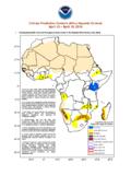
1 Climate Prediction Center s Africa Hazards Outlook July 12 July 18, 2018 Another week of heavy rainfall sustained moisture surpluses in southwestern Mali, Chad, eastern Sudan and western Ethiopia. NO Hazards Note: The Hazards Outlook map on page 1 is based on current weather/ Climate information and short and medium range weather forecasts (up to 1 week). It assesses their potential impact on crop and pasture conditions. Shaded polygons are added in areas where anomalous conditions have been observed. The boundaries of these polygons are only approximate at this continental scale. This product does not reflect long range seasonal Climate forecasts or indicate current or projected food security conditions.
2 Questions or comments about this product may be directed to or 1-301-683-3424. Moderate to heavy rainfall continues over many places in the Sahel region During the past seven days, many places in West and Central Africa continued to receive moderate to locally heavy rainfall. According to the satellite rainfall estimates, weekly rainfall totals exceeded 75mm over southwestern Senegal and Mali, parts of northern Guinea-Conakry, local areas in Nigeria, and southern and eastern chad, with the heaviest weekly totals registered over local areas in southwestern Mali, and southeastern and eastern Chad. Very heavy rainfall amounts were also recorded over portions of the Darfur region of Sudan (Figure 1).
3 Western Senegal, much of Liberia, eastern Burkina Faso, northern Ghana, and northeastern Nigeria continued to receive light to moderate rainfall. Another week of moderate rainfall was observed over Cote d Ivoire and southern Ghana, sustaining favorable ground waters and adequate cropping conditions in the region. In general, precipitation totals remained average to above-average over much of the Gulf of Guinea countries, except for pocket areas in Senegal, Liberia, eastern Burkina Faso, and northeastern Nigeria since early June. In general. 30-day rainfall totals remained above average over many places in the Sahel region (Figure 2). Analysis of the anomalous number of rain days since the beginning of June also suggests favorable conditions throughout West Africa , with only a few areas in Burkina Faso and Senegal registering a few rain days below normal.
4 During the next week, another week of potentially heavy rainfall is forecast across the western Sahel, with weekly rainfall accumulations (>75mm) expected over Guinea-Conakry, Sierra Leone, southern Mali, and farther east over already the Darfur region of Sudan. More seasonable rainfall is expected throughout the Gulf of Guinea countries. Heavy rains expected, over already wet areas of western Sudan, may pose threats for flooding Moisture surpluses prevail over eastern Sudan and Ethiopia According to satellite rainfall estimates, another week of heavy rainfall sustained moisture surpluses across eastern Sudan and western Ethiopia.
5 Weekly rainfall totals exceeded 100m mm over the far eastern Sudan bordering Ethiopia, and in western Tigray, Benishangul-Gumuz and Amhara regions of Ethiopia (Figure 1). Light to moderate rainfall amounts were also throughout parts of Yemen, South Sudan, Uganda and Kenya. A dipole pattern in rainfall anomalies is evident in the Greater Horn of Africa region. Normal to above normal rainfall prevailed across Sudan Eritrea and northern Ethiopia, while rainfall totals remained below-normal across southern South Sudan, southern Ethiopia, northeastern DRC and portions of the Lake Victoria region (Figure 2). This dipole pattern is associated with the unusual northward shift of the ITF during mid-June and early July.
6 While average to above-average rain has benefited agricultural activities over areas of Sudan and western Ethiopia, consistent rain could also pose threats for flooding and water-borne disease outbreaks over some areas. During the next week, there is an increased chance for moderate to heavy rainfall to continue over western Ethiopia and parts of Eritrea .The potential for above-average rainfall is expected to benefit Kiremt fed cropping areas, and alleviate local areas in western Oromia where some anomalous dryness has been observed. Satellite Estimated Total Rainfall (mm) Valid: July 3 July 9, 2018 Figure 1: NOAA/CPC Satellite Estimated Percent of Normal Rainfall (%) Valid: June 10 July 9, 2018 Figure 2: NOAA/CPC