Transcription of Coastal Flood Hazard Benefits of Coastal Flood …
1 May 2013 1 877 FEMA MAP Coastal Flood Hazard Mapping Studies Analyzing Coastal hazards is a high priority for FEMA because of population increases and development density in Coastal areas. Advances in data collection and policy changes are also reasons why FEMA is conducting new Coastal studies. Why is understanding Coastal Flood hazards so important? Eight of the top 10 most expensive natural disasters in our Nation were caused by Coastal storms. According to the 2010 census population counts, about 39 percent of the population live in counties bordering the ocean and Great Lakes coast.
2 Because of Coastal development and population increases over the past decades, a greater number of structures are at risk for damage from Coastal hazards . What is FEMA doing to improve risk awareness and resiliency in Coastal communities? FEMA initiated Flood Hazard studies for the Nation s Coastal areas as part of its Risk Mapping, Assessment, and Planning (Risk MAP) effort. In addition to the development of Flood Insurance Rate Maps (FIRMs), Risk MAP projects also offer a Flood Risk Report, Flood Risk Database, and other custom products. The data from these studies will benefit Coastal communities by increasing public risk awareness, improving mitigation planning, and encouraging mitigation actions.
3 Why is FEMA conducting new Coastal Flood Hazard studies? FIRMs in many Coastal areas are outdated due to the age of the data and methodologies used in producing the effective FIRMs. Some of the data and methodologies date back to the mid-to-late 1970s. Major changes in the National Flood Insurance Program have also occurred since the effective date of many Coastal studies, creating the need for updates to reflect more detailed and complete Hazard of Coastal Flood Hazard Mapping Studies Updated Flood Hazard data and maps to help Coastal communities understand their risk Improved risk assessment tools and Hazard mitigation planning assistance to help communities reduce their risk Compiled data, tools.
4 And resources for Coastal outreach and mitigation New Coastal webpages on Additional Resources FEMA maintains a variety of resources to assist Coastal communities and property owners in better understanding their Flood risk and taking steps to protect themselves from loss of life and property. For more information, please visit FEMA s Coastal website: For answers to questions about new FIRMs, the status of a request, or other mapping issues: FEMA Map Information eXchange 1-877-FEMA-MAP (1-877-336-2627) FEMA Map Service Center For answers to questions about Flood insurance: The NFIP Call Center 1-888-379-9531 FloodSmart For general information on FEMA and its programs: May 2013 1 877 FEMA MAP What are preliminary Flood Insurance Rate Maps (FIRMs)?
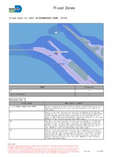
5 Preliminary FIRMs provide information regarding changes in Coastal Flood hazards , while offering communities an opportunity to submit feedback and/or additional data before the maps become effective. The majority of the preliminary Coastal FIRMs will be released in FY13, FY14, and FY15 (October 2012 through September 2015). Where can I find out the progress of my community s Coastal Hazard mapping study? The Risk MAP Progress website (accessible through FEMA s Risk MAP webpage) offers an interactive map that allows users to zoom in, locate their community, and click to learn about the project status ( time frame for their preliminary and effective maps). The data shown within the Risk MAP Progress website is updated each quarter of the fiscal year.
6 Risk Map Progress Website Screenshot How does FEMA determine the Coastal Flood risk for communities? FEMA works with scientists and engineers from other Federal agencies, State, regional, community, Tribal, non-profit, nongovernmental, contractors, and private-sector partners to analyze Flood hazards for Coastal communities using the latest scientific methodologies. By building on existing data and working with local community officials to produce new data and Hazard mitigation tools, FEMA s updated Coastal maps will provide communities with more accurate FIRMs, risk assessment tools, and outreach support. What determines each communities Flood insurance rates and other requirements?
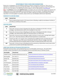
7 The effective FIRMs for each community drives Flood insurance requirements, Flood insurance premiums, and the requirements for new and improved buildings. Coastal Zones Graphic The graphic above shows FEMA s identification of Coastal Flood Hazard zones and how Base Flood Elevations (BFEs) are affected by wave heights. Areas in Zone VE (also known as the Coastal High Hazard Area) are likely to have flooding with waves that are three feet or greater. Areas in Zone AE will have waves less than three feet in height. Within Zone AE, the Limit of Moderate Wave Action (LiMWA) identifies an area where higher building standards are encouraged to promote safe development. Communities that adopt the LiMWA as a higher standard may earn Flood insurance rate discounts.
8 Flood zones and BFEs are used to determine Flood insurance costs and building requirements along the coasts. NFIP participating communities within the Special Flood Hazard Area (SFHA), which includes Zones VE and AE, must follow NFIP floodplain management regulations and property owners may be required to purchase Flood insurance by their mortgage lender. FEMA provides Coastal construction technical guidance for those who wish to build stronger and safer, and possibly reduce their insurance premium. In an effort to reduce losses of life and property along the coasts, these updated Coastal Flood Hazard studies will benefit communities by offering updated Flood maps, data, and Hazard mitigation tools.
9