Transcription of Continental Puzzle: Exploring Pangaea and Continental Drift
1 Continental Puzzle: Exploring Pangaea and Continental Drift By Alyssa Dehn Grade Level : 6 Benchmarks : NGSS of Earth MS ESS2 3: Analyze and interpret data on the distribution of fossils and rocks, Continental shapes, and seafloor structures to provide evidence of the past plate motions. Objectives: The students will be able to use electronic tools to explore the history of Earth s surface. The students will be able to identify the evidence for Continental Drift and locate them on a map The students will begin Exploring movement of plate tectonics and seafloor spreading The students will be able to calculate the rate of Continental movement.
2 Materials and Setup: Large, white sheet of construction paper Scissors for each student 9 x 12 construction paper for each student Glue sticks Markers One computer per student Google Earth application Download kml file Investigation. 1 Continental Drift V2 120907 One shoebox Paper Calculator per student Ruler with millimeters per student Tape measure or meter stick Safety: None Requisite Knowledge/skills for students: Scientific method Some knowledge of plate tectonics Some knowledge of the layers of the Earth Geography names of continents Some experience with Google Earth Multiplying Dividing Procedure 1 Engage.
3 (15 mins) Before focusing on the continents of the world, I created a fake world, or candy land , to allow the student s to come up with their own pieces of evidence for a hypothesis. For my candy land I divided a large piece of white construction paper into 6 pieces. I added several features that went across a few of the continents, such as candy canes, chocolate kiss mountains, fossilized gum drops, and chocolate and caramel deposits. I added individual features to each continent because not all of earth s continents are the same, including a continent with Sour Patch kids or another with York patties.
4 After drawing and coloring the features I cut out the six pieces, ready to be handed out to 6 groups of students to fit the pieces together. The students will first observe their piece of the world and then compare it with their neighbors to see if theres any similarities. They will begin to notice some of the pieces fit together or have matching characteristics. Key Left picture : Light brown portion = caramel deposit Plant like drawings= fossilized laffy taffy Cherries= clues of colder environment because they are associated with sundaes like in the york continent Colorful circles = fossilized gumdrops Right picture : Dark brown portion = chocolate deposit Chocolate kisses = Kiss Mountains Red tubes = twizzlers Lollipops on far right The students can come up with their own key together as a class after fitting all of the pieces together.
5 The teacher will inquire the class on how they decided which pieces fit together by asking each group questions such as: 2 What features on your continent were similar to another group s? What was different about your continent compared to others? What do you notice about the cherries? Why are some cherries on top of ice cream while other s are not? (Think climate) Other questions to trigger inquiry: What hypothesis could you propose about our candy world? Would you have supporting evidence for this hypothesis? Could this world be compared to our world?
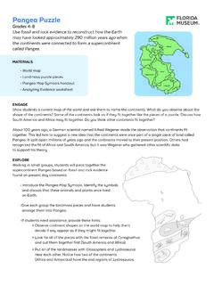
6 Puzzle like continents and features that may line up. The teacher can then begin introducing Alfred Wegener and tell the students he believed the continents were like a torn up piece of newspaper: you can line up the edges so that the words line up perfectly. Explore: teacher will inform the students that one of the first things Wegner noticed about the continents was that they almost fit together like puzzle pieces. She/he will ask the students to look at a world map and ask if they see any continents that might fit together. Using the Continental cutouts, the students will try to fit the continents together like a puzzle.
7 The teacher should let the students know that they won t fit together exactly and ask why this might be. After cutting out the continents and fitting them together, the students can glue them onto a piece of construction paper and use for the next activity. (15 minutes) After completing their Continental puzzle and before moving on to the next activity, the teacher should explain that what they created is a supercontinent called Pangaea . will be using Google Earth to go on a software led exploration of the evidence that supports the theory of Continental Drift .
8 Teacher Prep for Google Earth exploration : to on Module 3 Plate Tectonics to the right under Featured Content Investigation 1: Continental Drift download first item on the list, Continental Drift Google Earth file 3 to Google Earth application and you should be able to find the file under Places on the left double click it. click the folder icon below and it will show four different folders for each set of evidence that the students will go through themselves. Using the Pangaea Exploration Field Journal, the students will record their observations as they go through each step.
9 The students can also mark their findings on their Continental cutouts using different symbols for each piece of evidence, keeping track of their symbols in a key. As the students are working, the teacher should walk around and ask the students questions about what evidence they are finding, what supports the evidence, and how that evidence may support Continental Drift . More in depth questions can be asked during the explanation. (25 30 minutes) Explain: (40 mins) When the students are finished, the teacher will break up the class into 6 different groups: 2 groups will discuss the geographic evidence, 2 other groups will focus on the fossil evidence, and the last two groups will discuss the rock evidence.
10 Each group will present what they found with their piece of evidence using a map or their Continental cutouts to explain their information. The teacher can use the slide show provided to help guide the discussion. The teacher could also provide a dry erase map on a projector or a blank world map underneath a document camera that the students could use to present their findings for the whole class to see. Questions the teacher can ask for each group and the class as a whole: Geographic Evidence She/he can ask each group to point out two different Continental connections.