Transcription of Creating a Health Profile of Your Neighborhood A How-To …
1 Creating a Health Profile of Your NeighborhoodA How-To Guide Health data can help you create a Neighborhood Health Profile so that you can plan the best course for addressing critical Health issues. Here are the basic steps: 1. Know the Health issues affecting your neighbors Find and interpret Health -related data2. Prioritize needs Identify the most critical causes of death and disease3. Take action Use the data to shape policies, programs, and Neighborhood activities that address Health needs and promote a high quality of life for allCreating a Health Profile gives citizens a roadmap for making their Neighborhood a healthier place to live, learn, work and following resources will help you find Health data on your for Local Data Important to Planning and Public Health Your state, county, or local Health department.
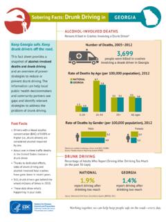
2 Your state Health department and its Web site often have the best Health resources for your community. They may have Health information for your county or even for the census tract(s) where your Neighborhood is located (census tracts are small, statistical subdivisions of a county). Sometimes county or local Health departments also track this information, or have created profiles based upon data available from the state. Your state, county, or local public safety department. Your public safety department and/or state law enforcement keep records of crime rates, types of crime, and incidence and often have this data organized available by Neighborhood , census tract, or community statistical area. Police departments can also be the best resource for traffic crash statistics. They have data identifying the types of crashes, the areas with the highest crash rates, and if alcohol was a factor or not.
3 Your state, county, or local transportation department. Not all places have an independent department of transportation. In some places, planning, construction and maintenance of the transportation network is handled by a department of public works or related agency. These departments may also be a good resource for records on traffic crashes, as well as information on traffic safety improvements that have been done in your community. HINT: Census tract data is one of the best sources for Creating a Neighborhood Health Center for Environmental HealthDivision of Emergency and Environmental Health ServicesCS241353 Online Resources for Local Data Important to Planning and Public HealthCounty Health Ranking and Roadmaps: The Rankings are based on a model of population Health that emphasizes the many factors that, if improved, can help make communities healthier places to live, learn, work and play.
4 This Web site allows you to compare your county to your state and the nation. Step 1: Click on your state on the map. Step 2: On the left hand side is a column listing the state counties. Click on a county to see its: Health Outcomes (morbidity and mortality); and Health Factors ( Health behaviors, clinical care, social and economic factors, and physical environment). Optional: Scroll down the main page and click on Build Your Own Roadmap. Building your roadmap will provide you with the tools and resources to help make your community a healthier place to live, learn, work, and National Public Health Track Network Community Design Indicators: The Tracking Network is a system of integrated Health , exposure, and environmental data from a variety of sources including national, state, and city sources. The tracking network provides data users standardized environmental and Health data, information by location, maps, charts and tables.
5 For example, the tracking network has community design indicators, including, maps, charts and tables on types of transportation to work, air quality (ozone and PM ), access to parks, and motor vehicle-related fatalities. Examining such data can help inform healthy community design decisions. Step 1: Click on the More link under the Environments subheading. Step 2: Click on the Search Community Design Data link located under the Community Design subheading. Step 3: Select indicator from the drop-down menu. Step 4: Select measure from the drop-down menu. Step 5: Select state(s). Step 6: Select year(s). Step 7: Select advance options (optional). Step 8: Click Run Query. Hint: Upon running your query, you can Return to your query panel selections by clicking the arrows in the upper right hand corner next to View Query Panel.
6 Click on the yellow Options and Info tab in the upper right corner to find map view options, the data source, and related information. Note: Mining data in the Tracking Network s Environment page subheadings Climate Change, Outdoor Air, and Water is also recommended as community design can have an effect on these areas. 23 CDC Chronic Disease Indicators (CDI): [A] cross-cutting set of 97 indicators that were developed by consensus and that allows states and territories and large metropolitan areas to uniformly define, collect, and report chronic disease data that are important to public Health practice. In addition to providing access to state-specific indicator data, the CDI web site serves as a gateway to additional information and data resources. Data viewable by: State, select counties Comparison: Yes, multiple selections Some of the data available: Physical Activity and Nutrition Tobacco and Alcohol Cancer Cardiovascular Disease Diabetes Arthritis Overarching Conditions ( poverty, high school completion, Health insurance, etc.)
7 Other Diseases and Risk Factors ( asthma, dentist visits, flu vaccinations, etc.) Step 1: Select your state/area. Some counties are represented but not all. Step 2: You have the option of selecting an area (or more) for comparison. If you d like to compare with multiple selections, hold the Control key as you select. Step 3: Select a category of indicators from the drop-down menu, or select All Categories to see them all. Step 4: Click Search . Interpreting the Data: A table will show indicators within a Health category, the prevalence of each in your area of interest and in your comparison area of choice. You can view indicator definitions by clicking on the view definition link. The link will give you the background, significance, Healthy People 2010 Objectives, and more. 4 Behavioral Risk Factor Surveillance System: The Behavioral Risk Factor Surveillance System (BRFSS) is a state-based system of Health surveys that generate information about the Health , Health risk behaviors and Health care access of a city and county.
8 BRFSS data can help identify emerging Health problems, establish and track Health objectives, and develop and evaluate public Health policies and programs. Data viewable by: State, MSA Comparison: Yes, if All is selected Some of the information available (not a complete list): Alcohol Consumption Asthma Cardiovascular Disease Diabetes Physical Activity Health Care Access Overweight and Obesity (BMI) Step 1: Go to Step 2: You can search by specific Metropolitan Statistical Area (MSA) or select All to compare your MSA with others around the country. Step 3: Choose year and click Go. Step 4: Choose one of the listed topics, and a particular subtopic when it appears. Interpreting the Data: Results will appear in table and graph form. In the table, percentages are weighted to population characteristics and the n represents actual number of survey responses.
9 Note: The Results page may have links to county-specific data. HINT: If you d like to see a quick graph of data comparing a selected MSA with State and Nationwide data on Health Status, Diabetes, Flu Vaccination, Current Smoking, Binge Drinking, and Obesity, click the Quick View Charts link on the left side of the screen (under the CDC logo).5 Youth Risk Behavior Surveillance System (YRBSS): The Youth Risk Behavior Surveillance System (YRBSS) monitors six types of Health -risk behaviors that contribute to the leading causes of death and disability among youth and adults, YRBSS includes a national school-based survey conducted by CDC and state, territorial, tribal, and local surveys conducted by state, territorial, and local education and Health agencies and tribal governments. Data viewable by: State, local site (typically city or MSA), territories, other (Navajo or Nez Perce nations) Comparison: Yes, by clicking View 2 Locations on the upper right of the results page Important Information: Behaviors that contribute to unintentional injuries and violence Sexual behaviors that contribute to unintended pregnancy and sexually transmitted diseases, including HIV infection Alcohol, tobacco, and other drug use Unhealthy dietary behaviors Inadequate physical activity Prevalence of obesity and asthma Step 1: Above the map, select your location by state, territory, or other populations.
10 Note: Below the map you can toggle between high school and middle school survey data but can t view both at the same time. Click Go. You can also choose your state by clicking on the map. Step 2: Under Choose Table Content, you can select all or specific questions or years. You can also filter data under Filter Data in the left hand column HINT: Click on Location, select Local, and you may find a drop down selection for your borough, county or city. This will make the data more specific to your community. Step 3: Under View Data by Demographics, you can filter by Sex , Race , Grade , or Totals Only .Food Environment Atlas: This map tool highlights a number of food access issues including grocery store proximity, availability of convenience and specialty food stores, WIC and SNAP authorized stores, restaurants, availability of local foods and farmer s markets, socioeconomic data, food prices and taxes, and Health and physical activity.