Transcription of Cuilcagh Way - WalkNI
1 Cuilcagh WayA Walker s GuideA32A5090510 kilometresBelcooBlacklionEnniskillenSwan linbarCuilcagh MountainLoughMacneanUpperUpperLoughErneL ough MacneanLowerN16A406 - walk 1 Cladagh Glen walk 08 - walk 2 Cuilcagh Legnabrocky Trail10 - walk 3 Cuilcagh Hiker s Trail12 - walk 4 Legacurragh Valley Trail 14 - walk 5 Florencecourt Forest Trail16 - Cuilcagh Way Information18 - Marble Arch Caves Global Geopark19 - Visitor InformationWelcome to the Cuilcagh Way The Cuilcagh Way is a waymarked route that stretches for 33km through a breath taking patchwork of habitats in southern Fermanagh.
2 It leads from the lowlands around the Cladagh River, past the Marble Arch Caves, to the blanket bog summit of Cuilcagh Mountain at 666 metres. The route can be walked in sections and provides stunning views, fascinating geology, mystifying wildlife, captivating archaeology and natural history: enough to whet anyone s appetite for adventure. Contents02 | | 03 View of Benaughlin from LegacurraghFlorence Court Forest Trail at BrookfieldOSNI or OSI Discoverer Series map 1:50,000 Sheet 26 OF THE Cuilcagh WAY 04 | | 05 walk 1 - Cladagh Glen walk The walk follows the course of the Cladagh River, meandering through a steep gorge that is thickly covered by a long established ash woodland and alive with wildlife.
3 Route: Red | Distance: : Gravel pathways, boardwalks and steps. walk 2 - Cuilcagh Legnabrocky Trail The route meanders through one of the largest expanses of blanket bog in Northern Ireland, traversing over tracks, boardwalk and mountain path. A steep climb is required to reach the 666 metre summit of Cuilcagh Mountain. Route: Blue | Distance: : OSNI or OSI Discoverer Series Map - Sheet 26 Terrain: Gravel track, wooden boardwalk and exposed mountain path. Full mountain precautions and experience required. walk 3 - Cuilcagh Hiker s Trail A vigorous and exposed route through expansive blanket bog, involving a steep climb to reach the summit cairn of Cuilcagh Mountain, offering breathtaking views over the surrounding landscape.
4 Route: Pink | Distance: 9kmMap: OSNI or OSI Discoverer Series Map - Sheet 26 Terrain: Mostly mountain blanket bog, crossing wet, uneven ground. Full mountainprecautions and experience required. walk 4 - Legacurragh Valley Trail Meander through limestone landscape, blanket bog and deep woodland before reaching Florence Court House Estate. Route: Green | Distance: : Heathland trail crossing wet, uneven ground, forest track and woodland 5 - Florence Court Forest Trail Weave your way through the Florence Court Forest Park before reaching the rolling Marlbank hills with their species rich grassland and exposed rocky outcrops of limestone.
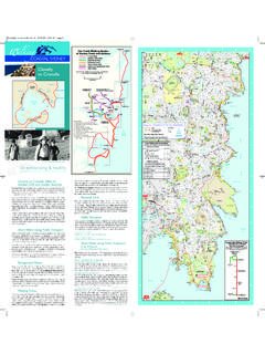
5 Route: Purple | Distance: : Forest track and heathland trail. Surface is largely firm, but some rough sections five stages of the Cuilcagh Way are waymarked, linear routes. There is car parking and interpretation panels at the start locations of all the ToiletsNational Nature ReserveFlorence Court House and GardensInformation panelRestaurantAccess for the disabledFootpathsRoadsVehicle TrackParkingPicnic areaContoursRiversForest Area012 kilometresWalk start/finish pointsCuilcagh Legnabrocky Trail666mTo SwanlinbarCuilcagh MountainsLoughCrattyLoughAtonaBenaughlin 370mGortmaconnellRockMarble Arch CavesFlorenceCourtHouse CuilcaghMountainParkFlorencecourtGortalu ghanyViewpointreviR nwarnihgAreviR naerbnewOTo EnniskillenTo BlacklionTo BlacklionTrien424mCladagh
6 RiverCladaghGlenMAP LEGENDC ladagh Glen WalkLegacurragh Valley TrailFlorence Court Forest TrailCuilcagh Hiker TrailRed Trail Florence CourtGeological siteFinding your way The Cuilcagh Way is fully 1 - CLADAGH GLEN WALKC ascades WaterfallA32 PNNRPPPNNRPPPP ublic ToiletsNational Nature ReserveFlorence Court House and GardensInformation panelRestaurantAccess for the disabledFootpathsRoadsWalk start/ nish pointsVehicle TrackParkingPicnic areaContoursRiversForest Area012 kilometresCuilcagh Legnabrocky Trail666mTo SwanlinbarCuilcagh MountainsLoughCrattyLoughAtonaBenaughlin Cuilcagh370mGortmaconnellRockMarble Arch CavesVisitor CentreFlorence Court Forest ParkCuilcaghMountainParkFlorencecourtGor talughanyViewpointreviR nwarnihgAreviR naerbnewOTo EnniskillenTo BlacklionTo BlacklionTrien424mCladagh RiverCladaghGlenMAP LEGENDC ladagh Glen WalkCuilcagh Hiker's TrailLegacurragh Valley TrailFlorencecourt Forest TrailGeological siteCladagh Glen walk The path starts at the car park at the bottom of Cladagh Glen and meanders through the woods following the course of the Cladagh River.
7 The river gurgles and splashes on its journey towards the Erne lowlands, bringing life to the woodland. If you are lucky you may spot a grey heron or dipper feeding in the rock strewn water. The undergrowth glows a vibrant green, with moss and woodland ferns carpeting the ground beneath native ash trees. A profusion of bluebells, wild garlic and woodland plants add colour during the spring and summer, while elusive animals like red squirrels and pine martens find shelter beneath the trees. Though it was once widespread, this sort of damp ash woodland is now rare in Ireland, walk 1 - CLADAGH GLEN WALK06 | | 07and the entire gorge is protected as part of the Marlbank National Nature Reserve.
8 After 1km you pass the Cascades Waterfall, a spring in the limestone where crystal clear water can be seen gushing down a natural staircase, after re-emerging from the Cascades cave system. At the head of the gorge the path reaches the Marble Arch, a spectacular natural archway that spans the river and is the remnant of a former cave. The path takes you up and over the Marble Arch, where craggy holes in the limestone offer glimpses of the turbulent river beneath. Leaving the river, the path winds slowly uphill through deep woodland. The woodland has several large depressions (shakeholes) where the sound of gurgling water provides evidence of the network of underground rivers making their journey through the Marble Arch Caves, beneath your feet.
9 The trail continues to the Marble Arch Caves Visitor Centre, where you can enjoy a guided tour of one of Europe s finest showcaves or recharge yourself in the Visitor Centre before taking the final jaunt south from the Visitor Centre, along the Marlbank country road to the Cuilcagh Mountain Park car park. Cladagh Glen Did You Know?The Cladagh Glen takes its name from the Cladagh River which is formed in the depths of the Marble Arch Caves when the Owenbrean, Shruhcroppa and Aghinrawn Rivers come together. The Cladagh River re-emerges from its underground journey at the Marble Arch Rising to makes its way winding and twisting down through the narrow-steep sided gorge of the Cladagh Glen.
10 Marble ArchWALK 2 - Cuilcagh LEGNABROCKY TRAILWALK 2 - Cuilcagh LEGNABROCKY TRAIL08 | | 09 Arriving on the edge of the summit plateau, a rough path continues east across the rock-strewn upland. The sweeping view along the summit plateau is broken by a large stone cairn, which is actually the remains of a burial mound dating from the Bronze Age (2,500 500 BC). This vantage point, the highest in County Fermanagh provides fabulous 360 views of the surrounding lowlands. On an exceptionally clear day you can see both the Irish Sea and the Atlantic Ocean along with several surrounding counties.