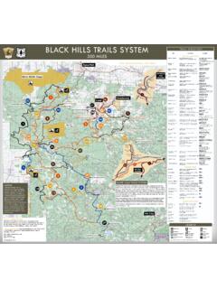
Transcription of Custer State Park Trail Guide - South Dakota
1 Custer State ParkTrail CLARK TRAILTRAIL RATINGSEASY: The Trail mainly follows level : Parts of the Trail follow steep slopes and rocky : Much of the Trail follows very steep slopes and rocky , ETIQUETTE & SAFETYTo ensure you have a safe and pleasant hike, please review the following etiquette and safety tips: Trails within Custer State park are marked with blue diamonds. The Centennial Trail is marked with gray diamonds and brown fi berglass posts. Trails in the Black Hills National Forest are marked with tree blazes. Water is not available along the trails. Always carry water with you. Camping within Custer State park is only allowed in designated campgrounds and in the French Creek Natural Area. Open fi res in Custer State park are only allowed in established campgrounds and day use areas.
2 Leave what you fi nd: Removing plants, rocks, antlers and other items from Custer State park is prohibited. Pets must be leashed. Trail courtesy: Bikers yield to hikers, and both yield to horses. Stay on the Trail , do not cut switchbacks. Pack out what you pack in. Collect litter along trails and dispose of it when you return to camp. Let someone know where you are going, what trails you are hiking, and an estimated time of return. Always be aware of weather conditions. Afternoon thunderstorms are common. Dress appropriately. Poison ivy is often found along trails near streams and is abundant in the French Creek Natural Area. Custer State park is home to one of the largest publicly owned bison herds in the world. These are wild animals and are dangerous.
3 Keep your distance. Rattlesnakes are sometimes seen in Custer State park . Be aware of your surroundings. Horseback riding is allowed except in those areas posted closed. Closed areas include the Sylvan Lake watershed and the Grace Coolidge Walk-In Fishing Area. In addition to the designated trails, hiking is allowed anywhere in Custer State park . Some areas may be posted closed to recreational activities due to resource management concerns. Black Hills National Forest maps and other sources of information about hiking, mountain biking and horse trails may be obtained at either of the park s visitor centers and at local Clark Historic TrailLocation of Trailhead: miles South of US 16A on Badger Clark Road (CSP 9)Length: 1 mile (loop)Time: 1 hourDiffi culty: ModerateLocated behind the historic Badger Hole, this Trail winds through a mixed pine and hardwood forest and along rocky hillsides.
4 A portion of the rock-lined Trail was built by poet laureate Badger LakeBadger Clark Historic TrailLegion LakeShore TrailCentennial TrailTBadger HoleCREEKSIDE TRAILGRACE COOLIDGE WALK-IN AREAC reekside TrailLocation of Trailhead: Parallel to US 16A. Runs from Game Lodge Campground to Grace Coolidge Campground. Trail may be accessed at various points along Highway : 2 miles (one way)Time: 1 hourDiffi culty: Easy (handicap accessible)This hard-surfaced Trail follows Grace Coolidge Creek and passes the State Game Lodge, Peter Norbeck Visitor Center, Coolidge General Store and the park offi may park at any of these locations to access the Trail . Several bridge crossings are bike and rollerblade friendly. The Trail is fairly level except for a section near the park offi ce where bicyclists should walk their Coolidge Walk-In Fishing AreaLocation of Trailhead: South end - park -ing area along Hwy 16A, across from Grace Coolidge Campground; North end - Adjacent to swimming beach at Center LakeLength: 3 miles (one way) Time: 2-3 hoursDiffi culty: Easy to moderateThis nearly-level Trail follows Grace Coolidge Creek, crossing it many times as it meanders through the valley.
5 Crossings may be diffi cult any time of the year, and you will get gently from the spillway of Center Lake, the creek contains six lowhead dams. The ponds and creeksides offer excellent trout fi shing and provide habitat for the variety of plants and wildlife found in this unique Offi ceCreekside TrailLover s Leap TrailTTGame Lodge AreaPeter Norbeck Visitor Center4 Grace Coolidge Campground5 Center LakeAreaCenter Lake RdS Playhouse RdGrace Coolidge TrailWalk-in Fishing AreaCreekside TrailTTGrace Coolidge CampgroundUS HWY 16 ALOVER S LEAP TRAILLEGION LAKE TRAIL6 Legion Lake TrailLocation of Trailhead: Within Legion Lake CampgroundLength: 1 mile (loop)Time: 1-2 hoursDiffi culty: Moderate to strenuousThis Trail winds through the ponderosa pine forest and offers views of Legion Lake and the surrounding area.
6 Parking is located at Legion Lake Resort. Hikers must walk across Highway 16A and all the way into Legion Lake Campground to access the Trail . The trailhead is located near campsite s Leap TrailLocation of Trailhead: Across Highway 16A from the Peter Norbeck Visitor Center, behind the schoolhouseLength: 3 miles (loop)Time: 2-3 hoursDiffi culty: Moderate to strenuousThis Trail begins with a steep ascent through a mature ponderosa pine forest with views of the State Game Lodge and the surrounding area. The Trail follows the top of a ridgeline. At the highest point on this ridge is a rocky outcrop named Lover s Leap. According to legend, it is on that outcrop that two Native American lovers leaped to their deaths. Mount Coolidge, Harney Peak and the Cathedral Spires can be viewed from this high point.
7 West of the Trail is an area that was burned in the 1988 Galena Trail continues down the side of the ridge into the Galena Creek Drainage. Once in the creek bottom, the Trail crosses the creek many times. The fi nal portion of the Trail passes a residential area and follows a gravel road back to the Coolidge Store. From there, a paved footpack leads past the chapel and back to the past the chapel and back to the Offi cePeter NorbeckVisitor CenterCreekside TrailLover s Leap TrailGame Lodge AreaLover s LeapLookoutT7 Legion Lake TrailCentennial TrailLegion LakeLegion LakeShore TrailBadger ClarkHistoric TrailCentennial TrailTLegion LakeCampgroundCentennial Trail ConnectorHARNEY PEAK TRAILSHARNEY PEAK TRAILSS ylvan Lake Trailheads to Harney PeakLocation of Trailhead: Sylvan Lake Day Use Area north of Needles Highway (Hwy 87)Two trailheads are located at the Sylvan Lake Day Use Area.
8 Trail 9 begins across the footbridge leading to the swimming beach. Trail 4 begins at the southeast corner of the day use Peak Trail #9 Length: To Harney Peak, miles (one way) Diffi culty: ModerateThis Trail is the most traveled and shortest route to Harney #4 Length: To Harney Peak, miles (one way) Diffi culty: ModerateThis Trail connects to the Little Devil s Tower trailhead, and continues on to Harney Peak. Trail 4 ends at the intersection of Norbeck Trail 3. Norbeck Trail 3 continues past Grizzly Creek Trail 7 and intersects with Harney Peak Trail 9. Harney Peak Trail 9 will take hikers to Harney Peak. Watch for the intersections with Norbeck Trail 3, Grizzly Creek Trail 7 and Harney Peak Trail 9 in the Black Elk Wilderness. These are easy to miss especially on the return Devil s Tower Trail #4 Location of Trailhead: 1 mile east of Sylvan Lake on Needles Highway (Hwy 87)Length: miles (one way)Diffi culty: StrenuousA spur Trail branches off Trail 4 and ascends to the unique rock formation known as Little Devil s Tower.
9 Views of the Cathedral Spires, Harney Peak and the southern Black Hills can be seen from this summit. The spur ends at Little Devil s Spires Trail #4 ALocation of Trailhead: miles east of Sylvan Lake on Needles Hwy (Hwy 87)Length: miles to Cathedral Spires (one way)Diffi culty: StrenuousFeatures the Cathedral Spires/Limber Pine Area, a Registered National Natural Landmark. Trail intersects with Trail #4 and can provide access to Harney Peak; however, Cathedral Spires Trail itself is a one-way of the most popular trailheads to Harney Peak (7,242 ft) start within Custer State park and continue across the boundary to the Black Hills National Forest and Black Elk Wilderness. There are different regulations within the State park system and within the national forest and wilderness Peak TrailsOpen fi res in Custer State park and Black Hills National Forest Service are only allowed in designated fi re grates in established camp-ground and day use State park Regulations Trails are marked with blue diamonds Stock is prohibited on the Harney Range trails within the park Camping is allowed only in designated campgrounds Pets must be leashedBlack Elk Wilderness Regulations Trails are marked with tree blazes and signs at intersections Stock are allowed on trails, unless otherwise noted Camping is allowed anywhere EXCEPT within mile of Harney Peak and Trail 9.
10 And at least 100 feet from water sources Pets must be leashed or under strict control Visitors must register at any of the major trailhead portals into the wilderness and carry registration form with them Groups are limited to 25 beating hearts (stock, pets and hikers combined) - groups of 10 or less are recommended Only non-mechanized, non-motorized transportation; no bikes, strollers, etc. 98 Tips for Hiking in the Harney Range Wear shoes suitable for rugged terrain Take extra clothes; it will likely be windy and cooler at Harney Peak; be prepared for rain Take at least one quart of water per person NO RESTROOMS located along the trailsHARNEY PEAK TRAILSHARNEY PEAK TRAILSHARNEY PEAK TRAILSHARNEY PEAK TRAILSC uster3 milesustustustustustussssssssssusssssssu sususuuuCuCuuuCuCuCCCCCCCCCCCCCCCCCCCCCC CCCCCCCCCCCCCCCCCCCCCCCCCCCCCCCCCCCCCCCC CCCCCCCC erererrereemiimimimimiiiiiiimiiiimimimmm mmmmmmmmmmmmmm3333 3 33 3333333333333333333333333333333333333333 3lleslesesleslesleslessssslsesssBlack Elk WildernessBicycles prohibitedHorsethief LakeWillow CreekLittle Devil s Tower*Iron CreekHorse CampHarney Peak(El.)