Transcription of Day Hike -South Kaibab Trail
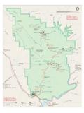
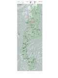
1 Day Hike - south Kaibab Trail Grand Canyon National Park National Park Service Department of the Interior Trail Condition: Maintained dirt Trail . Steep. Well defined. Very little shade on Trail , mostly from canyon walls and dependent on time of day. Give uphill hikers the right of way. Upper portion of Trail may be extremely icy in winter or early spring. Directions to Trailhead: Located on the south Rim, access to trailhead is by shuttle bus only, NO private vehicles allowed. Trail begins south of Yaki Point on Yaki Point Road. Trailhead Elevation: 7,260 feet. Services: Randomly patrolled by rangers. water available year-round at trailhead. Note: NO water along Trail .
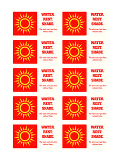
2 There will be mules on this Trail . The south Kaibab Trail offers wonderful views all along the Trail making it very easy to lose track of how far down you have hiked. Additionally, the steepness of the Trail is very misleading on the way down. Plan on taking twice as long to hike up as it took to hike down. Cedar Ridge has great views and is an ideal day hike. There are restrooms at Cedar Ridge. Everyone needs to carry water ! A common mistake is not carrying water or not carrying enough water . When hiking in a group, each person should be carrying water . Remember to eat as well as drink while hiking, you use a lot of energy hiking the canyon. MULES AND HIKERS - Several recent encounters between hikers and mules resulted in injuries to packers and the death of some mules.
3 To ensure safety for yourself, other Trail users, and mule riders, when encountering mules on the trails: 1. Step off the Trail on the uphill side away from the edge. 2. Follow the direction of the wrangler. Remain completely quiet and stand perfectly still. 3. Do not return to the Trail until the last mule is 50 feet (15 meters) past your position. DO NOT attempt to hike from the rim to the river and back in one day, especially May to September. Destination Distance (in Miles) Elevation Feet (at Destination) Services: W = water ; T = Toilet; E = Emergency Phone One Way Round Trip Services Notes W T E Ooh-Aah Point .9 6660 Offers a spectacular view.
4 Great day hike. No sign, point where Trail opens to a WIDE view. No water . Cedar Ridge 3 6120 X Good turn-a-round for first time canyon hikes, casual hikers, and late starters. Restrooms. No water . First hitching rail. Do not go past this point as a SUMMER day hike. Skeleton Point 3 6 5200 First view of river. Trail sign, second hitching rail is located after flat stretch on top of ridge. Steeper switchbacks after hitching rail. No water . Do not go past this point as a day hike. WARNING: Do not attempt to hike from the rim to the river and back in one day! Avoid trouble by Hiking Smart Plan your hike before you start. Balance your food and water intake. Eat salty snacks and drink water or sports drinks. Go slowly, rest often, stay cool.
5 Allow the weakest hiker to set the pace. During the summer, hike during the cooler, shadier times of the day. Depending on how prepared you are, your trip can be a vacation or a challenge, a revelation or an ordeal. Over 250 people are rescued from the canyon each year. The difference between a great adventure in Grand Canyon and a trip to the hospital (or worse) is up to YOU. Shuttle Bus Information Kaibab /Rim Route - Buses provide transportation between the Grand Canyon Visitor Center, Mather Point, the Yavapai Geology Museum, south Kaibab Trailhead, and Yaki Point. This is the shortest scenic route and the only access to Yaki Point and the south Kaibab Trailhead. Hiker s Express -An early morning shuttle bus goes to the south Kaibab Trailhead from Bright Angel Lodge shuttle bus stop, the Backcountry Information Center, and Grand Canyon Visitor Center daily, year-round.
6 Parking is available at the Backcountry Information Center. For shuttle bus schedules and stops visit Additional information on trails, distances, seasonal hiking tips, Frequently Asked Questions, and safety tips, can be found on the Backcountry Hiking section of the Grand Canyon web site at