Transcription of Don Carter State Park Trail Map
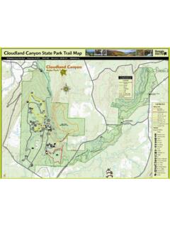
1 Private Property Parallel Trail Parallel Trail Huckleberry Trail Huckleberry Trail Lakeview Loop Lakeview Loop Terrapin Cove Trail Terrapin Cove Trail Terrapin Cove Trail Terrapin Cove Trail Woodland Trail Woodland Trail Woodland Trail Woodland TrailOverlook TrailOverlook Trail123456789101112B12345678 CSCS$HH5000 N. Browning Bridge Rd, Gainesville, GA, 30506 park : 678-450-7726 Reservations: 1-800-864-7275 Don Carter State park Trail MapEMERGENCY NUMBERS: 911 or call / text TrailLakeview Loop Trail *Overlook TrailParallel Trail *Terrapin Cove TrailWoodland Trail *BeachBeach HouseBoat RampBoat SlipCabinsCampCamp HostComfort StationCourtesy DockFish Cleaning StationFishing PierDog Creek Loop Paddle TrailFlat Island Paddle TrailLost Cove Loop Paddle TrailWhale Tail Paddle TrailSwim LineGuard ShackInformation KioskKayak ShackNo Motor BoatsParkingPicnic ShelterPlaygroundRestroomVisitor Center / park OfficeBCSH$Link to Google MapLink to This Map*Paved.
2 No Color BlazesPaddle Boat Rental/ConcessionsMOBILE APP01/41/2 MilesLonely Mans IslandWhales TailPaintedBluffsDog CreekMallard sCoveRockyPointFlat CreekIslandLEGENDDog Creek Loop Paddle TrailFlat Island Paddle TrailLost Cove Loop Paddle TrailWhale Tail Paddle TrailBoat RampBoat SlipBoat Dock Tell someone your itinerary and expected return time. Take a map, compass, water, snacks, first aid kit (with moleskin), jacket (extra layers), flashlight, insect repellant, rain gear (prepare for hypothermia), trash bag, cell phone, and whistle. Cell phones may not work in all areas, but if they do, be able to give details about your location. Pack out all trash. Paddlers will also need to wear a PFD (personal floatation device) at all times and pack plenty of water and sunscreen. Watch out for hazards such as poison ivy, yellow jackets/wasp/bees, fire ants, ticks, and copperheads/rattlesnakes. All plants and animals are protected by law. Protect the park and help prevent erosion by staying on marked trails.
3 Keep pets on a leash at all times and clean up after them. A Georgia State ParkPass is required to be displayed in each TIPS & ETIQUETTELAKEVIEW LOOP (PAVED)This half-mile, paved loop Trail is fairly easy that provides great views of the lake (20 to 30 minutes). Parking is available in the gravel trailhead parking lot which is across from the Beach/Picnic area. This Trail and the connecting Woodland Loop are ADA accessible and open to bicycles and strollers. The Lakeview Loop Trail begins at the edge of parking lot near the information kiosk. Take a right from the kiosk to begin your hike. When you reach the first junction, you can turn either to the left (for an easier hike) or to the right (for an extra workout). Signs will warn of the only steep grade on this route. This path provides access to walk-in campsites #11 & #12. A short spur Trail on the left leads to the fishing pier and boat ramp. Keep to the right to remain on the Trail and return to the parking area.
4 The Lakeview Loop Trail may be walked together with the Woodland Loop to form a mile, figure-eight loop. Paved connector trails also lead across the street to the beach and to the Huckleberry TRAILThis mile, partial-loop Trail has a natural surface (dirt), is fairly easy and is intended for foot traffic only (30 to 45 minutes). Parking is available at the upper end of the North Boat Ramp (furthest from the water). It can also be accessed from other connecting trails. This Trail is fairly wide and is marked with white blazes. The Huckleberry Trail begins as a spur, extending onto the peninsula. As you approach the loop portion of the Trail , you may hike in either direction for views of the lake. Return back to the spur for views of the Beach Cove. The Trail gets its name from the abundance of native Georgia huckleberries, which are related to blueberries. WOODLAND LOOP (PAVED)This 1-mile, paved loop Trail is a fairly easy walk (30 to 45 minutes).
5 Parking is available at the gravel trailhead parking lot which is across from the Beach/Picnic Area. This Trail and the connecting Lakeview Loop are ADA accessible and open to bicycles and strollers. The Woodland Loop Trail begins at the edge of the parking lot near the information kiosk. Take a left to begin your quiet stroll through the forest. This path also provides access to walk-in campsites, #1 thru #7. Signs will warn of the only steep grade on this route. The Woodland Loop Trail may be walked together with the Lakeview Loop to form a mile, figure-eight loop. Paved connector trails also lead across the street to the beach and to the Huckleberry CarterPARK Trail DESCRIPTIONS AND OTHER INFORMATIONOVERLOOK Trail (PAVED)Spanning only several hundred yards, this short, paved Trail leads along a ridge to the end of a knob overlooking a fern laced creek and hardwood bottom. This Trail is a great appetizer to the rest of the park s Trail system.
6 Parking is available at the Visitor Center. It is ADA accessible and also has swings located along the way. Although this path is paved, it is intended for foot traffic only and is marked with white blazes. Beyond the paved portion, the Trail leads to a set of rock steps that connects to the Terrapin Cove Trail . If you turn to the left on the Terrapin Cove Trail , you ll reach the Beach/Picnic Area (1/8th mile). Taking a turn to the right will lead you to the campground and TRAILSDog Creek Loop: 1-mile, easy. Take a leisurely float around the cove from the kayak shack at the boat ramp. Explore the western, smaller part of the cove wetlands or fish in shaded Creek Island Trail : 3-mile, more difficult. Travel upstream (no current) to the most northern island in Lake Lanier. See rocky bluffs, reedy swamps and explore 1-mile Flat creek near the northern end. Lost Cove Loop: 2-mile, moderate. Cross the main channel of the Chattahoochee into a larger cove and explore another tributary of the mighty Tail Trail : 2-mile, moderately difficult.
7 Traverse across more open water as your travel downstream (no current) towards the park s largest peninsula, the Whale Tail. Stay in the main center channel for full sun, or explore the shorelines for more plants and COVE TRAILThis 1-mile, linear Trail has a natural surface (dirt) and serves as a connector for the Beach, Visitor Center, RV Campground and Cottages, in that order. This Trail has become a popular, out-and-back hike (2-mile, round-trip) because of its scenic views as it hugs the shoreline. The Terrapin Cove Trail is a single track Trail , designed for foot-traffic only, and is marked with red blazes. Day-use parking is available immediately on the right as you enter the Beach/Picnic Area or at the Visitor Center. Overnight guests may access the Trail from the campground (by way of small spur trails) or from an area near the South Boat Ramp. The Trail gets its name from an old Appalachian term for turtle, perhaps referring to the box turtles living in the ,125'1,100'1,075'1,050'0 ,200'1,175'1,150'1,125'0 ,125'1,110'1,075'0