Transcription of Downeast Region Cobscook Bay - Maine
1 Downeast Region Dennys- Pe mb Cobscook Bay Directions State park ville ro ke 86. Take Route 1 to 1. Edmunds and look for South Edmunds Rd park signs marking the M. turnoff onto South Ed- Cobscook Bay ar State park munds Road. The main io Edmunds n park entrance is on the Tw Twp right miles from the p Whiting turnoff. 189 tt co es Tr Twp Fees Lat / Lon guide & map Overview Property History Arthur Downing All fees are payable at the park 's entrance booth. Camping Fees & Reservations: Contacts T he wildlife-rich waters of Cobscook Bay surround this 422-acre park on three sides, providing opportunities to watch birds and observe the ebb and flow of the Region 's impressive tides.
2 Cobscook , the Maliseet-Passama- quoddy tribal word for boiling tides, aptly describes this The park 's geology is shaped by three primary forces: Cobscook Bay's powerful tides; the underlying bedrock (a volcanic tuff- breccia that dates back to the Silurian Age roughly 420 million years ago); and the glacial action from the Wisconsinan ice sheet (approximately 12,000-18,000 years ago) which deposited Cobscook Bay State park 40 South Edmunds Road setting where the tidal range averages 24 feet and can reach 28 mud and an assortment of rock, sand, silt and clay known as Edmunds Twp, Maine 04628 feet (compared to a 9-foot average tide along Maine 's glacial till.)
3 These sediments form a thin layer over the bedrock 207-726-4412 southernmost coast). that rarely exceeds 10 feet. Where the bedrock is exposed, grooves left by the ice sheet (known as glacial striations) are visible Cobscook Bay State park is a great base for family camping and park & Trail Alerts: Text DACF COBS to 468311 on rock surfaces. One of the first geologists to explore the area, explorations in easternmost Maine . Many of the park 's 106. Nathaniel S. Shaler, noted in 1886 that Cobscook Bay offers a campsites (both for tenting and RVs) border Whiting Bay, a Travel Information more interesting assemblage of phenomena than can be found sheltered inlet within the larger bay.
4 The park offers a boat Region : on any other part of the eastern seaboard of the United states .. launch for those with the experience to handle boating in Maine : Visit challenging conditions with rapids created by fast-moving tides. Services & Facilities Cobscook Bay is an unusual estuary with a narrow opening to Cobscook Bay State park is part of Moosehorn National Wildlife Refuge, much of which was first purchased in 1937 with funds Tent camping (walk-to & drive-to options); RV camping (no the sea, a long and convoluted shoreline, and relatively few from the federal Duck Stamp Program.)
5 Moosehorn (which now hookups) and 5 lean-to sites; Camper trailer dumping station feeder streams and rivers. Nutrient-rich salt water flowing in totals 24,400 acres) is one of the nation's oldest refuges, having Picnic tables (some covered) and fire rings A great base for from the Gulf of Maine stimulates plankton growth, which in turn feeds a vast array of invertebrates (such as shellfish and been designated a National Wildlife Refuge in 1937 by President Franklin D. Roosevelt, who summered on nearby Campobello Privies & potable water family camping and exploration marine worms).
6 Eagles, ospreys, seals, otters and even the Island in New Brunswick. Hot showers for campers occasional bear enjoy the Bay's abundant fish, including smelt, in easternmost Maine alewives, shad, sea-run brook trout, striped bass and the In 1964, the Refuge offered the State of Maine a long-term Area guides and brochures at park entrance Atlantic salmon. lease at no cost on a Recreation Area it had created along Group picnic area with lean-tos Whiting Bay. After approval by the Maine Legislature, management Grassy playground area and recreational field The Bay's productive food web nourishes more than 200 bird of the area was transferred to the State and Cobscook Bay State species (see for more details).
7 Miles of hiking trails park was established. Funding from both the Land for Maine 's Attracted by Cobscook Bay's sheltered coves, mudflats, and Public boat launch Future program and the Land and Water Conservation Fund eelgrass beds, thousands of shorebirds stop over each fall to contributed to this park . Official Maine State Parks Geocache: rest and forage as they migrate south from northern breeding grounds. The Bay's inner coves support a quarter of Maine 's wintering black ducks and the state's highest concentration of Recreational Trails Program This brochure was made bald eagles.
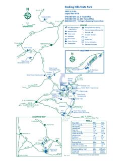
8 A free birding list for the Cobscook Bay Region is possible in part by funding assistance through the Federal available at the park entrance. Highway Administration's Recreational Trails Program (RTP), 2019 administered by the Maine Bureau of Parks and Lands. Visitor Rules Special Considerations Anthony's Camp Only at established sites, many of which can be When boating or exploring along the shore, be mindful of how Beach Trail 18L. De reserved in advance at Anthonys 100 23U 21U 20U 17M. quickly the tides can turn and move. Supervise children closely.
9 Nn Beach Trail ys Quiet Are required from 10:00 to 7:00 in Moosehorn National To Boat Launch Rd. 22U 19U 16X. vil Whiting le While daytime summer temperatures average about 68 F (20 Bay Mobile 24U. Hours camping areas. Camping Area Wildlife Refuge 13U. 14U. 15U. C.), evenings and gray days can be chilly. Downeast Maine is 1. und sR. d Harbor Point firetower 12U. Fires Are only allowed in grills or fireplaces provided famous for fog so be prepared for low visibility, particularly if Sou th E. dm Tenting Area 25U 8U. 10U 6X. by the park .
10 Leave your firewood at home; buy boating. In winter, expect daytime temperatures around 18 F. Nature Broad Cove Cobscook 9L 7U. Trail Tenting Point 11L. it where you burn it - at the park or locally. Out (-8 C.) and take extra care in snow and ice. Area Tenting Area 26U. 1L. of state firewood is banned to reduce spread of 27U 5U. (0..2. invasive pests. In late spring and early summer, be prepared for mosquitoes, black m Pa 2X. i). flies and midges (no-see-ums). While the area is not heavily infested Moosehorn rk Rd Burnt 3L 4U. Health & Put away food securely and leave picnic and National Cove Harbor Pt.