Transcription of Economic Expansion, 1841 - North Thurston Public Schools
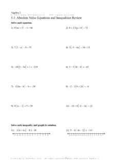
1 NATIONAL ANDREGIONALGROWTH21 Copyright McDougal Littell 3 nationalism and SectionalismNameDate11 Outline Map ActivitiesEconomic Expansion, the map on textbook page 355 to locate the following bodies of water, canals,roads, and cities. Then label them on the outline map on the back of this of WaterCanals and RoadsCitiesLake ErieNational RoadAlbanyPittsburghLake MichiganPennsylvania CanalChicagoClevelandLake OntarioMiami and Erie CanalToledoNew York CityHudson RiverChamplain CanalVandaliaWheelingOhio RiverErie CanalCincinnatiNew OrleansMississippi RiverChesapeake and Ohio CanalBuffaloColumbiaOhio and Erie labeling your map, use it to answer the following What two cities are the starting and ending points of the National Road?
2 _____2. Which body of water connects Albany and New York City? _____3. What two bodies of water do the Ohio and Erie canal join?_____4. What two cities did the miami and Erie canal connect ?_____5. Which canals on the map ran generally east to west?_____6. What cities shown on the map are located on the Great Lakes?_____7. How might a farmer in Toledo transport products to New Orleans using thecanals and bodies of water shown on the map?_____8. How might a merchant in New York City transport goods to Cleveland using thebodies of water and canals shown on the map?_____22 UNIT3 CHAPTER11 Copyright McDougal Littell Maps continued35 N90 W80 W95 W85 W75 W30 N40 N70 W00150 mi300 kmN