Transcription of Edexcel Geography A-level The Water Cycle and Water ... - PMT
1 Edexcel Geography A-level The Water Cycle and Water Insecurity Detailed Notes The Hydrological Cycle Global Water Budget The global Water Cycle is comprised of many stores, the largest being oceans, which contain 97% of global Water . Only of stores are freshwater of which 69% is glaciers, ice caps and ice sheets and 30% is groundwater .Surface and other freshwater only accounts for around 1%of global stores. Other surface and freshwater is made up of permafrost, lakes, swamps, marshes, rivers and living organisms . Hydrology in Polar Regions 85% of solar radiation is reflected Permafrost creates impermeable surfaces Lakes and rivers freeze Rapid runoff in spring Seasonal release of biogenic gases into atmosphere Orographic and frontal precipitation Hydrology in Tropical Rainforests Dense vegetation consuming 75% of precipitation There is limited infiltration Deforestation leads to less evapotranspiration and precipitation Very high temperatures Very humid Convectional rainfall % of total Water % of total freshwater Residence time Oceans 0 3600 years Icecaps 15,000 years Groundwater 10,00 years Rivers and Lakes 2 weeks to 10 years Soil moisture 2-50 weeks Atmospheric Moisture 10 days ITCZ (Inter-tropical Continental Zone)
2 The Earth consist of six cells of circulating air, which form the globe s climate control. For the Northern Hemisphere (the same is true for the south, just in opposite directions): Hadley Cell - Air rises at The Doldrums, travels upwards, then sinks as it meets the cooler air of the Ferrel Cell. At this meeting point, precipitation tends to occur. The air then travels southwards, heating up as it does. It will then have heated sufficiently to rise up at the Doldrums, commencing the Cycle again. Polar Cell - Cold air sinks near the Arctic Circle, cooling and condensing to form precipitation over northern latitudes. The air then travels southwards, heating until it meets warm air from the Ferrel Cell. The air then rises, causing dry conditions for the land beneath, and then travels northwards, cooling as it does.
3 Ferrel Cell - The middle cell of the ITCZ (tends to be at a mid-latitude location). The air circulation is determined by the Hadley and Polar cells either side, similar to a cog system. Drainage basins A drainage basin is an open subsystem operating within the closed global hydrological Cycle . It s defined as an area of land drained by a river and its tributaries with a boundary (known as the watershed ), usually composing of hills and mountains. The basic flows, inputs and outputs are shown below: On a local scale, the Water Cycle is an open system (a system of processes of Water inputs, outputs and throughputs); on a global scale , the Water Cycle a closed systems (a system that has no inputs or outputs, only throughputs). The Water Cycle contains flows/transfers, inputs, outputs and stores/components.
4 Inputs to the Drainage Basin Precipitation Precipitation is caused by the cooling and condensation of Water moisture in the atmosphere, forming clouds that release moisture in the form of rain, snow, hail, sleet, etc. Primary factors affecting volume or the condition of precipitation include: Seasonality In some climates (such as monsoon and Mediterranean) there are strong seasonal patterns of rainfall . Therefore the time of year determines the precipitation input within the drainage basin Variability - sudden or long term changes to the climate can happen, which would affect precipitation levels and so the drainage basin as a whole. Secular Variability long term (for example as a result of climate change trends) Periodic Variability annual, seasonal or monthly context Stochastic Variability random factors like localisation of thunderstorm Latitude - The location of the drainage basin has a major impact on climate, and so the volume and type of precipitation falling.
5 In most cases, the higher the latitude from the Equator, the colder the climate, and so snowfall occurs more often than rainfall . Also, at latitudes where air cells converge ( ITCZ ), the climate will be categorised by the rise or fall of air - Types of rainfall Convectional Often a daily occurance. The morning heat warms the ground, which in turn heats low-level moisture (from plant dew or surface stores). This moisture evaporates and rises. As the air rises, it cools and the moisture within will condense, to form rain and in turn (as more moisture accumulates) rainfall . In tropical climates , convectional rainfall is most common; within tropical rainforests, rainfall occurs mid-morning before the temperature rises too high for condensation to occur. Frontal/Cyclonic Where two air masses meet , a wedge can occur of hot air within cold air - this is called a depression.
6 At the front (were the two air masses meet), warm moist air is forced to rise above the cold air mass, causing the Water moisture within to cool and condense, to form cyclonic precipitation. Depressions are very common to the UK - approx 100 depressions hit the UK each year. Relief/Orographic When warm, moist air (often travelling onto land from sea) meets land of high relief ( hills), the air mass is forced to rise above the hill to continue travelling. As it rises, the air mass cools and the moisture within condenses, to form clouds and rainfall . Orographic rainfall depends on the relief and location of the land immediate after the sea - many coastal landscapes are too cold, low lying or hills are set too far inland for relief rainfall to occur. Fluxes and Flows within the Drainage Basin There are many flows within the drainage basin, many due to gravity and so depend on the relief of the land.
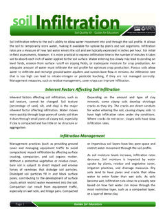
7 These flows occur at different speeds which can influence many things including Water balance and the likelihood of flooding Interception Interception is the direct intervention of plants leaves in changing the direction or temporarily stopping precipitation as it falls to the surface. Any moisture retained by the surface of the leaf ( interception store) is generally greatest at the start of storms. A plant s interception capacity varies depending on the type of vegetation. Infiltration The movement of Water from the surface into the soil. The infiltration capacity is the maximum rate at which Water can be absorbed by the soil, and can be affected by: Soil Composition Sandy soils have higher infiltration rates compared to clay. Previous precipitation - The saturation of soils will reduce infiltration rates, hence surface runoff increases after long, intense periods of rainfall .
8 Type and amount of vegetation - dense root growth can inhibit the infiltration of Water , and interception of plants leaves will delay infiltration (never stopped, as Water will never permanently remain on the leaf). Compaction of soils will reduce the infiltration rate. Relief of land sloped land will encourage more runoff , therefore less infiltration as a direct result. Surface runoff - Water flows overland, rather than permeating deeper levels of the ground. Overland flow occurs faster where the gradient of land is greater. Surface runoff if the primary transfer of Water to river channels, hence heavily influencing their discharge - Moderate/Fast Throughflow- Water moves through the soiland into streams or rivers. Speed of flow is dependent on the type of soil.
9 Clay soilswith a high field capacityand smaller pore spaceshave a slower flow rate . Sandy soils drain quicklybecause they have a lower field capacity , larger pore spacesand natural channelsfrom animals such as worms. Some sports fields have sandy soils, to reduce the chance of waterlogged pitches, but this may also increase the flood risk elsewhere - Moderate/Fast Percolation - Water moves from the ground or soil into porous rock or rock fractures (deeper bedrock and aquifers ). The percolation rate is dependent on the fractures that may be present in the rock and the permeability of the rock - Slow Groundwater Flow - The gradual transfer of Water through porous rock, under the influence of gravity.
10 Water can sometimes become trapped within these deeper layers of bedrock, creating aquifers and long Water stores for the drainage basin - Slow Outputs of the Drainage Basin There are three main outputs to a drainage basin; since the basin is an open system, often Water and moisture are transferred across the watershed. Evaporation This is the direct loss of Water moisture from the surface of a body of Water , the soil and interception storage (on top of leaves) to the atmosphere. Evaporation rates increase when the weather is warmer, windier and dryer. Alternative factors also influence evaporation rates: Volume and surface area of the Water body - the larger the surface area (more spread out), the faster the rate of evaporation. Vegetation cover or built environment surrounding the Water - anything that reduces direct sunlight to the Water body will reduce evaporation.