Transcription of Egypt Lesson Plan 7: Touring Ancient Egypt Introduction
1 Get More at: 2006 Public Broadcasting Service All Rights Reserved 1 Egypt Lesson Plan 7: Touring Ancient Egypt Introduction : This Lesson focuses on the importance of geographic features and the abundance of natural resources that helped Ancient Egypt become the world s first superpower. Students will learn about the geography and resources available to the Ancient Egyptians and create a multimedia tour that demonstrates this learning to others. Subject Areas: World History, Social Studies, Geography, and Communication Arts students Grade Level: 6-12 Lesson Objectives: Students will: 1. Participate in a class discussion where they hypothesize about the geographic and natural resources available in Ancient Egypt . 2. Analyze maps and their related data to learn basic facts about the geography and natural resources in the Ancient Egyptian Empire. 3. Use Internet resources to answer factual questions about the geography and natural resources of the Ancient Egyptians and how these were used as a part of everyday life.
2 4. Use their research findings to discuss how the geography and natural resources of Ancient Egypt helped the empire to become the world s first superpower. 5. Create a multimedia presentation that requires them to share their learning about Egypt s geography and natural resources by creating a virtual tour of Ancient Egypt . Relevant National Standards: McRel Compendium of K-12 Standards Addressed: World History Standard 3: Understands the major characteristics of civilization and the development of civilizations in Mesopotamia, Egypt , and the Indus Valley. Geography Standard 1: Understands the characteristics and uses of maps, gloves, and other geographic tools and technologies. Standard 2: Knows the location of places, geographic features, and patterns of the environment. Standard 3: Understands the characteristics and uses of spatial organization of Earth s surface. Get More at: 2006 Public Broadcasting Service All Rights Reserved 2 Standard 4: Understands the physical and human characteristics of place.
3 Standard 9: Understands the nature, distribution, and migration of human populations on Earth s surface. Standard 12: Understands the patterns of human settlement and their causes. Standard 17: Understands how geography is used to interpret the past. Language Arts Writing Standard 2: Uses the stylistic and rhetorical aspects of writing. Standard 3: Uses grammatical and mechanical conventions in written compositions. Standard 4: Gathers and uses information for research purposes. Reading Standard 5: Uses the general skills and strategies of the reading process. Standard 7: Uses reading skills and strategies to understand and interpret a variety of informational texts. Listening and Speaking Standard 8: Uses listening and speaking strategies for different purposes. Working with Others Standard 4: Displays effective interpersonal communication skills. Estimated Time: This should take two 90-minute class periods or three to four 50-minute class periods plus additional time for presentations and extension activities.
4 Materials Needed: Video clips necessary to complete the Lesson plan are available on the Egypt s Golden Empire Web site [ ]. If you wish to purchase a copy of the program, visit the PBS Shop for Teachers [ ]. Internet access for utilizing maps and conducting research. Ancient Egyptian Geography Study Guide [ ], part of this Lesson plan. Touring Ancient Egypt Project Guide [ ], part of this Lesson plan. Access to multimedia presentation software such as Power Point*. Get More at: 2006 Public Broadcasting Service All Rights Reserved 3 *Note: desktop publishing software could also be used if teachers wanted to modify the assignment to have students create documents such as travel brochures and newspapers. Procedures: 1. Using the Egypt s Golden Empire Web site s Virtual Egypt feature [ ], access the following 360 views: Deir El Medina view of village, Karnak Processional Way and the Temple of Ptah. Pose questions such as: Based on what you can see in the pictures, how would you describe the geography of Egypt ?
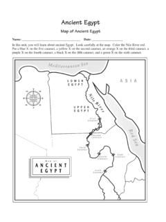
5 Discuss the types of resources, plants, animals, and climate you think the country would have. Based on the pictures, how would you characterize Egypt ? Please choose one: A. barren desert B. mountainous C. rocky plains D. fertile growing land Explain why. Is this a place you would like to live? Why or why not? 2. Explain to students that the Ancient Egyptians were one of the world s superpowers, and that knowledge about the geography of the country can help them understand how the Ancient Egyptians attained such power and status in the world. Distribute the Ancient Egyptian Geography Study Guide [Download PDF here (80k)] in this Lesson plan to each student and review the questions before accessing the maps. 3. Access a modern political map of Egypt similar to the one on the British Museum s Ancient Egypt site [ ]. Use it to find basic information about Egypt . Include in your search, bordering countries, Egypt s location on a world map and major bodies of water.
6 4. Access the British Museum s Geographical Features map [ ]. Choose the various symbols and highlighted areas to learn more about the quarries, mines, fertile lands, oases, the Nile River, and the river delta region. 5. Access the museum s Natural Resources map [ ]. Make note of important resources that were available in the different regions of the empire. Get More at: 2006 Public Broadcasting Service All Rights Reserved 4 6. Access the Archaeological Sites map [ ] and study where the temples, pyramids, and important sites are located. Think about how this correlates with the available resources and geographical features of the land. 7. Direct students to the Day in the Life feature [ ] and the Natural Resources content [ ] on the Egypt s Golden Empire Web site. Also refer them to the Farming content [ ] to answer the remaining questions in the Ancient Egyptian Geography Study Guide [Download PDF here (80k)] in this Lesson plan.
7 8. Once students have completed the study guide, review the questions. Have them discuss what they have learned about the importance of geography in making Ancient Egypt a superpower. Do this using questions such as: How did Egypt s terrain and physical features help to make it more powerful? What natural resources did the Ancient Egyptians use to help them attain and maintain themselves as a world power? Why was the Nile River critically important to the Ancient Egyptians? 9. After the class discussion is complete, distribute the Touring Ancient Egypt Project Guide [Download PDF here (76k)] in this Lesson plan. Review the requirements for the project and provide students with classroom time to create their presentations. Students could work individually or in small groups to prepare their projects. 10. When projects have been completed, invite students to gather into groups of four to eight to present their Tour of Egypt to one another.
8 Assessment Suggestions: 1. Students could receive participation grades for class discussion activities. 2. An accuracy grade could be assigned for completion of the Egyptian Geography Study Guide. 3. A scoring guide or project points checklist could be used to assess the accuracy of the information and the quality of Touring Ancient Egypt multimedia presentation (for instance, meeting all slide specifications). 4. Students could complete comment cards or peer evaluations of the presentations they view in their small groups. Get More at: 2006 Public Broadcasting Service All Rights Reserved 5 Extension Activities: 1. Using what they have learned about Ancient Egypt , have students compare and contrast Ancient and modern Egypt in terms of the available resources, how these resources are used, Egypt s current status as a world power, the significance of the Nile River and its delta, and so on. Students could do this by creating a set of collages showing Then and Now , by creating graphic organizers, or by writing a compare and contrast essay.
9 2. Compare the geography and resources available to the Ancient Egyptians with those we possess in the Examine how certain geographic features and natural resources could contribute to the making of a superpower and examine the commonalities between other areas of the world where great powers began and have continued to flourish. The PBS program Guns, Germs, and Steel [ ] provides a detailed look at this subject and could be used as a supplemental resource. Related Resources: The British Museum s Ancient Egypt site [ ] contains detailed information about the geography of the land as well as having a number of resource maps. Wikipedia s Ancient Egypt Web pages [ ] contain information about the geography of the area. There is also a color map showing key sites and features of the land. Minnesota State University has Web pages on Ancient Egypt and a Map of Ancient Egypt [ ]. This breaks the empire up into four areas that can be selected for greater detail.
10 The CultureFocus Map of Egypt [ ] shows key sites of New Kingdom structures and locations. your sentences on each slide.