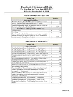
Transcription of EVALUATION OF RATIONAL METHOD “C” VALUES
1 EVALUATION OF RATIONAL METHOD C VALUES February 1998 (Original Report) June 2002 (Update for Manual Revision) Principal Author Joe Hill OBJECTIVES There are six objectives for this study. 1. Review the runoff factors C VALUES for the RATIONAL procedure specified in the current Design and Procedure Manual. 2. Review other references. 3. Review the more detailed land use elements that are identified in the County general Plan and estimate the percent of area that is impervious associated with each. 4. Develop an expanded table of C VALUES that are consistent with the existing VALUES , but provide a greater range of categories that relate to General Plan Land Use categories. Also, provide a mathematical relationship between land use, soil type that can be used more easily for computation and programming purposes. 5. Provide a table on CN VALUES for the County Land Use categories that are consistent with the County Hydrology Manual.
2 6. Provide a METHOD of determining C or CN VALUES for special situations. 1I. COUNTY OF SAN DIEGO HYDROLOGY MANUAL Table I shows the runoff Coefficient VALUES in the current Design and Procedure Manual. Table I Soil Group Land Use A B C D Single Family Multi-Units Mobile Home Rural (lots greater than acre) Commercial (80% Impervious) Industrial (90% Impervious) II. REVIEW OF C VALUES Numerous references that use the RATIONAL procedure were reviewed and the C VALUES and procedures of determining the runoff were evaluated. Examples include the procedures used by Riverside County, Los Angeles County, Orange County, City of San Francisco, City of Oakland, Denver Urban Drainage District, and references from APWA and ASCE.
3 County Flood Control has evaluated precipitation and stream flow recorded data since the Flood Control District was established in 1968. Extensive analysis of the methodology for the RATIONAL and unit hydrograph procedures has also been accomplished. This includes analysis of the runoff process and comparison of the two methods . This experience provides a basis for the development of this report. In 1969, Design and Construction of Sanitary and Storm Sewers and the 1992 Design and Construction of Urban Storm water Management Systems were published by the American Society of Civil Engineers and the Water Environmental Federation. This Manual gives a range of runoff coefficients VALUES for different land uses and types of ground surfaces as shown in Table II 2 Table II Land Use/Type of Surface Range of C VALUES Business downtown to Business in neighborhoods to Single family to Multi-units, detached to Multi-units, attached to Suburban Residential to Apartment to Light Industrial to Heavy Industrial to Parks and Cemeteries to Playgrounds to Railroad yard to Unimproved land to Asphalt and Concrete to Brick to Roofs to Sandy soil lawn, 2 percent slope to Sandy soil lawn, 2 to 7 percent slope to Sandy soil lawn, >7 percent slope to Heavy soil lawn, 2 percent slope to Heavy soil lawn, 2 to 7 percent slope to Heavy soil lawn, >7 percent slope to III.
4 SAN DIEGO COUNTY LAND USE ELEMENTS There are 28 different types Land Use Elements within the County of San Diego General Plan. Of the 28 Land Uses, 15 have densities of one or more dwelling units per acre and are listed in Table III with respect to their Land Use Element Number. The effective percent impervious is based on discussions with the Planning Department, EVALUATION of typical land use patterns, amount of roofs, driveways, parking surfaces, etc. that are direct/indirect connection to the storm system and the Soil Conservation Service (SCS) criteria in the County Hydrology Manual. 3 Table III Land Use Criteria SCS Elements County Elements** Land Use Element Number (%) Imper. Low Residential, DU/A* 2 10 Low Residential, DU/A* 3 20 Low Residential, DU/A* 4 25 Medium Density Residential, DU/A* 5 30 Medium Density Residential DU/A* 6 40 Medium Density Residential, DU/A* 7 45 Medium Density Residential, DU/A* 8 50 High Density Residential, DU/A* 9 80 High Density Residential.
5 DU/A* 10 65 Commercial/Industrial Office Professional/Commercial 11 90 Commercial/Industrial Neighborhood Commercial 12 80 Commercial/Industrial General Commercial 13 85 Commercial/Industrial Service Commercial 14 90 Commercial/Industrial Limited Industrial 15 90 Commercial/Industrial General Industrial 16 95 * Dwelling Units/Acre ** Land Use Element numbers 2 through 6 typically represent single-family, and Land Use Element numbers 7 through 10 typically represent townhouse, condominium, and apartment categories. Mobil Home Parks contain various amounts of pervious areas.
6 The County General Plan assigns the Mobil Home category to many Land Use Elements. In the unincorporated area, Land Use Element 8 probably best represents the typical Mobil Home Park. 4IV. EVALUATION OF THE runoff COEFFICIENT EQUATION AND VALUES Some of the rain that falls on pervious surfaces infiltrates into the soil and the remainder runs off. Most of the rain that falls on impervious surfaces runs off. For this study, 90 percent of the rain on impervious surfaces runs off. The 90 percent value is based on a review of literature, and is considered reasonable since most impervious surfaces, such as parking lots, streets, etc., have some pervious areas and water can infiltrate through cracks and other openings. There is storage of water on the surface in depressions and in the form of surface flow depth and storage in conveyance systems. See page 3-5 of Los Angeles County Manual.* The percent of rain that runs off from the pervious surfaces is the function of soil type A, B, C, and D.
7 runoff coefficients for Rural (lots greater than acre) land use are shown in Table I. These VALUES include a percentage of imperviousness. Table II shows a C value range of to for heavy soil lawns at 2 to 7 percent slopes. These VALUES are much lower than the Rural coefficients in Table I. A reduction of from the Rural coefficients is used to represent a more realistic value of runoff coefficients for pervious surfaces. These VALUES are represented in Table IV as the pervious coefficient runoff value (CP). Even with this reduction, these VALUES are higher than the lawn coefficients in Table II. Most single-family residential units have lawns and/or landscaped areas that are more previous than most natural soils and vegetation cover in the San Diego coastal and foothill area. Table IV PERVIOUS COEFFICIENT runoff value (Cp) Soil Type A B C D The Los Angeles County Manual* provides the following relationship: C = (% impervious) + CP (% pervious) * Department of Public Works Hydrology Manual, December 1991 edition.
8 Where the runoff coefficient is the percent that runs off from the impervious area plus the percent that runs off from the pervious area. The percent that runs off from an impervious area is 90 percent of the percent impervious, and the percent that runs off from a pervious area is CP times the percent pervious. 5 Using the relationship from the Los Angeles Manual, the percent pervious is 100 percent minus percent impervious value . The equation above can be rewritten as follows: C = (% impervious) + CP (1 - % impervious) (Eq. 1) C VALUES determined from equation 1 for County Land Uses and soil types are shown in Table V. Table V ADJUSTED runoff COEFFICIENT C Soil Type (Cp) Land Use (%) Imper. A ( ) B ( ) C ( ) D ( ) 2 10 3 20 4 25 5 30 6 40 7 45 8 50 9 80 10 65
9 11 90 12 80 13 85 14 90 15 90 16 95 6 The adjusted C VALUES shown in Table V provide a much more comprehensive basis for basin analysis that is consistent with the County General Plan. To provide a comparison with the C VALUES that are in the Design and Procedure Manual (1968) that was approved in 1968 and has been used since then, Table V-A compares the current VALUES Manual (1968) with the Adjusted VALUES .
10 The Land Use categories in the County General Plan that most closely represent the Manual 1968 Land Use classifications are compared in Table V-A. The largest discrepancies are for Soil Type A, Mobile Home and Multi-Units, which are different by 22 and 47 percent, respectively. Similarly, B soils have 16 and 34 percent increases. Since the amount of A soil in the San Diego coastal/foothill areas are relatively small, the percent differences would not significantly affect the computed flood flows in most basins. The adjusted VALUES are more representative of actual runoff since the impervious area factor is included more effectively than in the 1968 Manual. Table V-A COMPARISON OF C VALUES Soil Type Manual vs. Adjusted Land Use A B C D Manual (1968) Rural Adjusted L.