Transcription of Example Management Plan shared as part of the …
1 1 Example Management Plan shared as part of the Forest guild 's Ecological Forestry Initiative Management RECOMMENDATIONS Prepared by Russ Richardson For Jakelands LLC Farm LOCATION AND GENERAL WOODLAND DESCRIPTION This farm, consisting of 261 acres, is located in Washington Magisterial District of Calhoun County. None of the farm was logged during the past 25 years. Nearly 2/3 of the farm has a mixed hardwood and mixed oak forest cover that is of commercial size. 20% of the farm acreage is mixed oaks and hardwoods approaching commercial size with 15% of the property a mixture of old fields and pasture in the process of returning to forest cover.
2 Portions of the tract suffered moderate damage from the ice storm of February 2003. Approximately 10 acres of the woodland suffered severe damage during the ice storm. Portions of the tract where the ice damage is the worst have a building invasion by Japanese stiltgrass (Microstegium vimineum). The tract has interior access limited to foot travel. No timber harvesting has occurred in modern times and there are no developed oil or gas wells in the interior of the farm. The principal timber species include: yellow poplar, black, white, scarlet, chestnut and red oak, sugar maple, ash, hickory and red maple.
3 Black walnut, sourwood, sassafras, red bud, elm, black gum, locust and hophornbeam occur as associated species throughout the stands. The majority of the timber on the property is in the sawtimber size class. The sites are generally good quality for the production of forest products. The tract shows historical evidence of fires with none appearing to have been burned within the past twenty five years. No serious insect or disease problems were detected during this evaluation. However, an ongoing invasion by Chinese tree of heaven and Japanese stiltgrass is a serious threat to the future productivity of the farm and woodland.
4 Most of the stands on the property are at or nearing commercial size and the harvest of timber is a moderate to high priority for the woodland owner at this time. In much of the property where the sites are the most fertile, grape vines are a severe problem. The worst grape infestations are found in areas severely damaged by ice in 2003, these are also the worst places for the Microstegium invasion. * Total Volume 1,313,750 bd. ft. 1,360 cords The woodland consists of a variety of tree size classes and tree species which provides for the diversity needed by game and nongame species.
5 The recommended cutting practices, plantings and other cultural treatments will help regulate, on a continuing basis, the kind, amount and arrangement of food and cover needed by wildlife during all seasons of the year. LANDOWNERS OBJECTIVES The landowner is interested in starting a forest Management program that will improve 2 the long term value of the timber growing on the property while providing for an increased diversity of wildlife species along with enhanced opportunities for woodland recreation. The primary objective of this plan is to present recommendations designed to assist the landowner in meeting his goals while improving the quality of individual trees.
6 Management activities will be concentrated on the better quality sites where maximum returns from wood products and associated forest benefits can be realized. Employment of cultural treatments on the better woodland sites will also shorten the time necessary to produce a high quality sawlog or veneer product. Maximum benefits can be obtained by frequent treatments of each stand to maintain the best stocking of crop trees over the entire rotation. BOUNDARIES The boundaries to the property were surveyed in 2004. They are mostly old fence and are blazed painted and posted.
7 A boundary line map is shown on Page 5. Well-marked boundaries are an asset on any property and a must when timber is sold. All boundary lines should be marked with paint. Red is probably the most often used color. ACCESSIBILITY Access to the tract is average for Calhoun County. The farm has access from a private road that follows the Spruce Run valley to Frozen Run Road (Calhoun County Route 11/4). At this time there are no developed roads or trails to the upland portions of the Rubin property. Development and improvement of access trails into the woodland and maintaining them in an open condition will enhance recreational options and make the suggested and planned forest Management activities easier to implement.
8 Carefully planned access roads should be a part of any future timber sales. TOPOGRAPHY AND SOILS For soils information on the tract, refer to the soils map and woodland suitability information prepared by the Soil Conservation Service on Page 4. Elevation on the tract ranges from approximately 850 feet in the bottom of Spruce Run to over 1,300 feet in several locations along the east, west and north boundaries. Most of the tract is moderately to steeply sloping with easterly, northwesterly and southerly exposures. About 20% of the property has slopes with exposures to the southwest.
9 SITE INDEX Site index is a term used by foresters to describe the site productivity for a certain tree species or groups of tree species. The site index used in this plan is based on the height that a tree will grow on a particular soil in 50 years. If a tree grows 50 feet in 50 years, the site index is 50; if it grows 100 feet in the same time period, the site index is 100 and the larger the number, the higher the site productivity. Generally, the better sites are in the bottoms, hollows and on the northern slopes while the poorer sites are on the ridges and southern slopes.
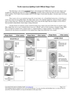
10 3 FOREST TYPES A pure forest stand is considered to be one in which 80% or more of the trees in the main canopy of the crown are of the same species. In a mixed stand, no species makes up more than 80% of the main crown canopy. There is no stand on the Jakelands property that is dominated by one species. The following are the timber types associated with this plan, see page 6. (OM) Mixed Oak (OH/OM) Mixed hardwood/mixed oak (OM/OH) Mixed hardwood/mixed oak (AF) Abandoned Fields (RI) Riparian RECONNAISSANCE AND CRUISE INFORMATION COLLECTED The timber on the property was inventoried using a variable plot sampling method.