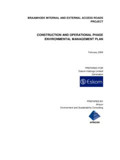
Transcription of FIGURE3. 1.1: SPATIAL DEVELOPMENT FRAMEWORK …
1 8 FIGURE3. : SPATIAL DEVELOPMENT FRAMEWORK OF NKANGALA DISTRICT MUMICIPALITY. 9 Transit Orientated DEVELOPMENT Transit Orientated DEVELOPMENT (TOD) is defined as a unique mix of land uses located at a high density within a predetermined walking radius of a railway station (see figure 20). TODs are purposely designed to facilitate access to the railway stations and to increase the use of the public transportation systems. Thereby land use and transportation integration can be achieved. TOD programmes seek to create high quality living and working environments, to improve station access, to implement local land use plans, and to increase tax revenue.
2 It also offers the possibility of enhanced utilisation volume, particularly off-peak and reverse-flow riders. Conservation, tourism and culture The Nkangala District offers considerable tourism potential (refer to figure . ). The economy of the eastern areas of the District is already growing due to the increasing popularity of tourist destinations in the Emakhazeni Municipality. The natural beauty, rural character and popularity of fly-fishing are the main attractions of this area. The north-western areas of the District also offer opportunities for tourism, through the consolidation of the various nature reserves and open spaces in this area.
3 Figure : SPATIAL Structure and Economic Activities within NDM 10 The northern and eastern regions of the Nkangala District already offer a variety of tourism opportunities associated with the scenic qualities, wetlands and conservation). A large part of the Emakhazeni Municipality forms part of the tourism Triangle, an area designated for tourism facilities associated with fly-fishing as part of the N4 Maputo Corridor initiative. The demarcation of a Tourism Belt and Focus Areas in the District will serve to promote and enhance the tourism potential in this area.
4 It should be noted that the intention is not to reserve this area purely for tourism developments or to exclude tourism developments from any other area in the region. The intention is rather to focus investment and incentives in this area, to the benefit of poor communities in the northern regions and rural areas. This Tourism Belt incorporates sensitive wetlands and conservation areas, nature reserves and some of the proposed ecological corridors in the District. Tourism and cultural nodes/corridors The tourism or cultural nodes and corridors to be promoted throughout the District, include: Belfast which has the opportunity to serve as a tourism gateway, due to the fact that tourists underway to the Kruger National Park along the N4 or Dullstroom/Pilgrim s Rest/Hoedspruit along the R540 (P81-1) have to travel through Belfast.
5 This centre could therefore be used to promote the tourism opportunities in the Tourism Belt and the entire District. The Bambi bypass route (R36) from Waterval Boven towards Montrose Falls in the Mbombela Municipal area which is already a very popular tourism route in the NDM area. Dullstroom, which is a major attraction point to tourists and is expanding rapidly. The major attraction to this area is however the rural character and scenic qualities, which should be protected from over-exposure and commercialisation. Associated with Dullstroom is the DEVELOPMENT of the R540 tourism corridor between Belfast, Dullstroom and Lydenburg towards the north.
6 Agriculture and Mining The agriculture sector is an important economic activity in the Nkangala District, which should be protected and promoted through the DEVELOPMENT of supplementary activities, such as agri-processing. Intensive agriculture is promoted along the N4 and N12 Corridors, to capitalise on the access to markets at local and regional level. Eco-tourism, agriculture and forestry are promoted in the eastern regions of the District, in support of the tourism sector. The northwestern regions of the District are characterised by subsistence farming and rural residential uses.
7 The initiation of 11 community farming projects is necessary to enhance the agricultural sector in this area and to address the high poverty levels. The District has considerable mining potential as reflected in figure The mining activities in the south of the region and especially in the Thembisile Municipality should be enhanced, to contribute to job creation for poor, unskilled workers. The regeneration of power stations, as well as the new power station in the Victor Khanye area could serve as catalyst to increased demand for coal reserves in the NDM area.
8 Figure : Geology and Minerals Business and industrial activities The occurrence of business activities in the District is closely related to the hierarchy of settlements. The business activities developed as a result of the demand for goods and services at service 12 centres, such as Middelburg, Emalahleni, Delmas, Belfast and the smaller town and villages in the , most of which act as central places to surrounding communities. The industrial potential of Belfast and Machadodorp to the east, and Delmas in Victor Khanye municipal area (agro-processing) to the west should also be promoted to capitalise on its strategic location in relation to the major transport network.
9 Hierarchy of service centres Cities fulfil the function of primary service centres, offering the highest order and widest range of goods and services to other towns and settlements as well as the rural areas. In terms of the secondary service centres, a distinction can be made between the existing and evolving centres. Delmas and Belfast are existing secondary service centres in the District, which fulfil the function of a central place to the surrounding rural areas and small villages. Capital Investment FRAMEWORK and Priority Investment Areas: (only Belfast for the purpose of this report).
10 Aspects to be addressed in respect of Belfast are: Creating a tourism gateway at the Belfast off ramp from the N4; Upgrading the entrance into Belfast from the N4 freeway in support of tourism DEVELOPMENT ; and Earmarking of land between the N4 freeway and railway line for industrial DEVELOPMENT Expansion of industrial/commercial areas towards the N4 Corridor 13 4. land REFORM AND land ADMINISTRATION. land restitution ( land claim) is one amongst three land reform programmes namely: Redistribution aims to provide the disadvantaged and the poor with access to land for residential and productive purposes.