Example: barber
FLOOD HISTORY OF MISSISSIPPI
Chickasawhay River Basins. Moderate to major flooding occurred along the Tombigbee River and tributaries above Columbus, MS. Record flooding occurred along the Tombigbee tributaries of the Luxapallila Creek and Noxubee River. The record to near record flooding continued on the Tombigbee into Alabama.
Tags:
Information
Domain:
Source:
Link to this page:
Documents from same domain
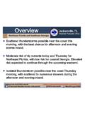
Overview Jacksonville, FL
www.weather.govBriefing Time: 7/30/2018 12:07 PM Caution: Do Not Use Beyond Eight (8) Hours from Briefing Time. Jacksonville, FL Weather Forecast Office US National Weather Service Jacksonville @NWSJacksonville Weather.gov/JAX

Lightning Safety When Working Outdoors
www.weather.govFactSheet. Lightning Safety When Working Outdoors. Lightning strikes can severely injure or kill workers whose jobs involve working . outdoors. Lightning is often overlooked as an occupational hazard, but employers
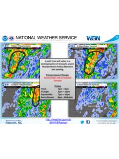
Heavy showers and thunderstorms could lead to …
www.weather.govWarning L Greensboro Watch Ash A' oro —"Carol'nà+san ham etteville Lumbèrtcm Mount Gree Kinston Advisory S
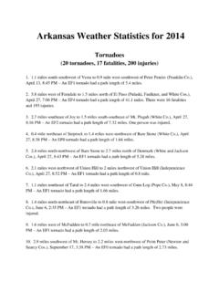
Arkansas Weather Statistics for 2014
www.weather.govArkansas Weather Statistics for 2014 ... 0.9 mile west of Bredlow Corner to 1.2 miles east-northeast of ... may be a week or more before tornadoes can be added ...
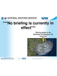
No Current Weather Hazard Briefing is in Effect. …
www.weather.govNo Current Weather Hazard Briefing is in Effect. Refresh this page frequently! Author: christopher.collins Created Date: 4/15/2014 11:46:45 AM
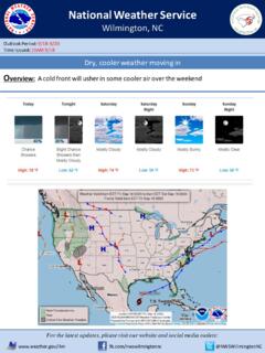
Forecaster #: 910-762-8724 Heavy rain expected …
www.weather.govWilmington . Title: PowerPoint Presentation Author: Terry Lebo Created Date: 7/24/2018 10:50:20 AM
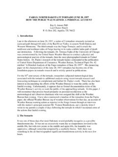
FARGO, NORTH DAKOTA F5 TORNADO JUNE 20, 1957 HOW …
www.weather.govFARGO, NORTH DAKOTA F5 TORNADO JUNE 20, 1957 HOW THE PUBLIC WAS WARNED: A PERSONAL ACCOUNT Ray E. Jensen PhD Last Chance Ranch P. O. Box 202, Aquilla, TX 76622
Groundhog Day Weather History for Peoria
www.weather.govGroundhog Day is celebrated on February 2. According to folklore, if is cloudy when a groundhog emerges from its burrow on this day, then spring will come early. If it is sunny, the groundhog will see its shadow and retreat back into its burrow, and winter weather will continue
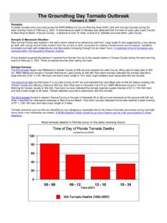
The Groundhog Day Tornado Outbreak - weather.gov
www.weather.govThe Groundhog Day Tornado Outbreak February 2, 2007 Synopsis: A deadly tornado event occurred across the NWS Melbourne County Warning Area within Lake and Volusia Counties during the
S u b se a so n a l a n d S e a so n a l F o r e ca st i n ...
www.weather.govD r a f t E xe cu t i ve S u m m a r y W i t h i n t h e p a st 2 0 ye a r s, t h e d e m a n d f o r su b se a so n a l - t o - se a so n a l ( S 2 S ) f o r e ca st i n f o r m a t i o n
Related documents
Case Study I* - The Ganga, India - WHO
www.who.intThere are 14 major river basins in India with natural waters that are being used for human and developmental activities. These activities contribute significantly to the pollution loads of these river basins. Of these river basins the Ganga sustains the largest population. The Central Pollution Control Board (CPCB), which is India's national body
Chapter-3 (Version 4) 07-01-06 - NCERT
ncert.nic.inriver systems but the following are the major river systems: The Indus System It is one of the largest river basins of the world, covering an area of 11,65,000 sq . km (in India it is 321, 289 sq . km and a total length of 2,880 km (in India 1,114 km). The Indus also known as the Sindhu, is the westernmost of the Himalayan rivers in India. It ...
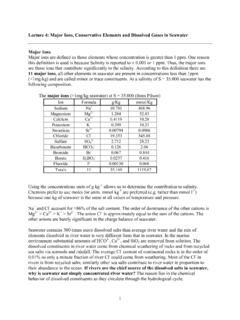
Lecture 4: Major Ions, Conservative Elements and Dissolved ...
ocean.stanford.eduMajor ions are defined as those elements whose concentration is greater than 1 ppm. One reason ... Seawater contains 300 times more dissolved salts than average river water and the mix of ... 2-is conservative in oxic oceans but not in anoxic basins or within sediments. Sulfate is used by sulfate reducing bacteria to form HS-or H
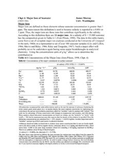
Chpt 4: Major Ions of Seawater James Murray (10/01/04 ...
www.ocean.washington.edu1. estuaries: The average composition of river water is given in Table 4-2 (from Langmuir, 1997). The concentrations are given in mg l-1 and can be compared with seawater concentrations. The main difference is that HCO3-is the main anion in river water and has a much higher concentration than Cl-(which is the lowest of the major anions in river ...

WIND RIVER RESERVATION - Indian Affairs
www.bia.govThe Wind River Basin Province is about 200 mi. long and 100 mi. wide, encompassing an area of about 11,700 sq. mi. Actual basinal area not capped by eroded Precambrian and/or Paleozoic rock is approximately 7,500 sq. mi. The Wind River Reservation comprises almost half of this basinal area, 3,500 sq. mi. All of the major
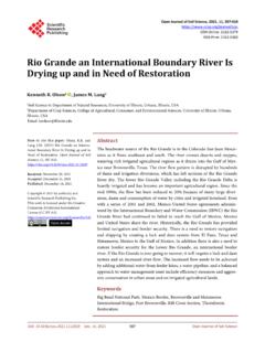
Rio Grande an International Boundary River Is Drying up ...
www.scirp.orgnavigation shipping and restore border security. The Rio Grande River headwa-ters are in Colorado (Figure 1) and the river flows along the Mexico-United States border and into the Gulf of Mexico. The watershed area is 472,000 km2 [1] without including the many endorheic basins near the Rio Grande basin. When
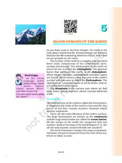
MAJOR DOMAINS OF THE EARTH
ncert.nic.inMAJOR DOMAINS OF THE EARTH As you have read in the first chapter, the earth is the ... and the huge water bodies are called the ocean basins . All the oceans of the world are connected with one another. Look at the map of the world (Figur e 5.1). Ar e ... world’s lar gest river , the Amazon. Australia is the smallest continent that lies ...
Basic Concepts of Groundwater Hydrology
groundwater.ucdavis.edurivers and floods (Figure 3). In these so-called alluvial basins,ground water fills small, often microscopic pores between the grains of gravel, sand, silt, …
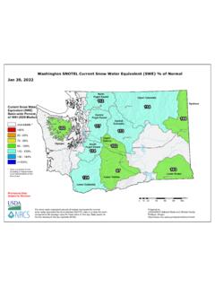
Washington SNOTEL Current Snow Water Equivalent (SWE) …
www.wcc.nrcs.usda.govSeattle Yakima Spokane Everett Cle Elum Winthrop Wenatchee Belingham Walla Walla Marblemount PortAngeles Olympia Upper Columbia Lower Yakima Lower Columbia