Transcription of Flood Risk Management for Caravan Parks in Victoria
1 Flood Risk Management for Caravan Parks in Victoria and A. Bewsher Bewsher Consulting Pty Ltd PO Box 352, Epping NSW 1710. AUSTRALIA. E-mail: Abstract This paper reports some of the key findings of a study aimed at assessing Flood risks and recommending strategies to manage Flood risks for Caravan Parks in Victoria . It is estimated that about half of Victoria 's 600+ Caravan Parks may be subject to flooding in the 100 year event, and many Parks are located within floodways. The use of Caravan Parks as places of permanent residence, as well as the trend towards an increasing number of immovable cabins, contributes to the vulnerability of Caravan Parks . Despite significant Flood risks , few Parks appear to be adequately prepared for flooding some would get little warning, some could not be evacuated in time, and few Parks have sound Flood emergency Management plans.
2 For proposed new Parks or park extensions, Flood risks can be managed through the planning system. For existing Parks , options include better identifying Flood risks , ensuring the provision of flash Flood warning systems where appropriate, and raising access roads. Much can be done to improve the quality of emergency Management planning in Caravan Parks , and a draft document containing guidelines and a template has been prepared to assist Caravan park owners to prepare meaningful Flood emergency Management plans and to provide councils with a standard against which they can assess the plans submitted for approval. Measures to encourage Caravan park owners to engage in Flood risk planning include a proactive approach by councils and CMAs, education via industry newsletters, and amendments to the relevant Regulation.
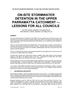
3 1. INTRODUCTION. A study of Caravan Parks in NSW indicated that many Parks were Flood -prone and that few Parks were adequately prepared for flooding. Recommendations were proposed to manage the Flood risk, particularly pertaining to planning controls (Yeo, 2001, 2003; Yeo & Grech, 2006). Flooding in Gippsland in June 2007 was a reminder of the Flood -prone locations of many Caravan Parks in Victoria . Media reports point to flooding of Caravan Parks along the Macalister, Thomson, Avon and Mitchell Rivers and around the Gippsland Lakes. A park at Bairnsdale was severely flooded for the third time in 17 years (Figure 1). Most of the cabins at Montana Caravan park in Glenmaggie were washed away. A study was conducted in 2005 to provide an overall assessment of Flood risks for Caravan Parks in Victoria , and to recommend best practice for managing the Flood risks (Bewsher Consulting, 2007).
4 This paper reports some of the key findings of that study, and also provides an update on the implementation of one of the recommendations of that study that a Flood emergency Management plan template with guidelines be prepared to help Caravan park owners prepare for flooding. A variety of methods were used to assess Flood risks in Caravan Parks in Victoria . Data from the Australian Bureau of Statistics (ABS) revealed trends in accommodation types within Caravan Parks . A GIS analysis was used to estimate the proportion of Caravan Parks in Victoria subject to flooding in the 100 year Average Recurrence Interval (ARI) event. A questionnaire was prepared and used by the CMA floodplain managers and the Consultant to interview park managers at 40 Caravan Parks .
5 Flood risk Management for Caravan Parks in Victoria Yeo Figure 1. Mitchell Gardens Caravan park in the April 1990, June 1998 and June 2007 floods Sources: Bairnsdale Advertiser (1990); unknown (1998); ABC (2007). 5th Flood Management Conference Warrnambool, 9 - 12 October 2007 2 of 10. Flood risk Management for Caravan Parks in Victoria Yeo 2. Flood RISK ASSESSMENT. How many Caravan Parks are at risk from flooding? A GIS layer for the 100 year ARI Flood extent was provided by DSE and Melbourne Water, and DSE. also provided a floodway layer, though it is recognised that the coverage of these layers is incomplete (about 80% of 100 year floodplains and 30% of floodways have been mapped) and the positional accuracy of the layers is mostly of low reliability.
6 A GIS layer for 302 out of Victoria 's estimated 619. Caravan Parks ( 49%) was prepared with the assistance of the Valuer General's Office. According to the GIS analysis, 38% of (the sample of) Caravan Parks lie partly within the 100 year ARI. Flood extent and 22% lie partly within floodways. Given the incomplete coverage and limited accuracy of the Flood mapping in some areas, this is regarded as an underestimate. A study of the City of Greater Shepparton's 17 Caravan Parks found that 11 (65%) are at least partially located within the 100 year ARI Flood extent. In the Consultant's opinion, it seems fair to conclude that that about half of Victoria 's Caravan Parks are at least partially Flood -prone, and more if Flood -prone land is defined by the PMF floodplain.
7 How vulnerable are Caravan Parks to flooding? Caravan Parks consist of a diversity of accommodation types including permanents (residential sites), annuals (where a Caravan or cabin is permanently situated in a Caravan park but used only occasionally for holiday purposes), and tourist accommodation (cabins, on-site vans, powered and unpowered sites). Figure 2 illustrates the median number of sites for each accommodation type based on the survey of 40 Caravan Parks . Most Parks provide at least a few sites for permanents , and one of the Parks had 90 long-term sites. Residents of Caravan Parks tend to be older and poorer than other Australians, which points to the potential difficulty of emergency evacuation (high level of aged) and reduced capacities to recover after floods by repairing or relocating (low savings and income levels).
8 Often the dwellings of residents in Caravan Parks are in practice immovable in the time before a Flood . Also contributing to the vulnerability of Caravan Parks is the tourist population, who may lack awareness of the Flood threat, and can dramatically swell the logistics of evacuation should a Flood occur during peak holiday season. The manager of a Caravan park with 400 sites estimated that 2,000 people stayed there at peak times. Furthermore, industry trends show that over the last decade, on-site vans, powered sites and unpowered sites which are generally occupied by dwellings that can be shifted have been replaced by tourist cabins which are usually not able to be shifted quickly (Figure 3).
9 This represents an increase in the amount and capital value of property exposed to Flood risks , though 33% of the surveyed Parks had raised the floor levels of all or most of their tourist cabins to reduce the frequency of inundation. How prepared are Caravan Parks for flooding? Figure 4 shows that 14 (35%) out of the 40 surveyed Caravan Parks are not currently part of the Bureau of Meteorology's (BoM's) quantitative Flood warning network. Figure 5 shows that 13 Parks (33%) have estimated available warning times of six hours or less ( are prone to flash floods ). An estimated seven Parks (18%) are believed to occupy dangerous shrinking island evacuation settings in the 100 year ARI Flood , where the park would first be isolated then completely inundated by a rising Flood (Figure 6).
10 Based on comparisons of effective warning times and the required times (estimated by park managers) to evacuate people and movable property from Caravan Parks , five Parks (13%). would have insufficient time to evacuate people and nine Parks (23%) would have insufficient time to evacuate property before the onset of flooding. This result highlights a real concern a number of Caravan Parks will not have sufficient time to evacuate the park prior to being inundated, posing a genuine threat to life and property. 5th Flood Management Conference Warrnambool, 9 - 12 October 2007 3 of 10. Flood risk Management for Caravan Parks in Victoria Yeo 8. 6%. Permanents 40 Annuals 60 32%. 49% Tourist cabins owned by park On-site vans owned by park Other tourist sites 12.