Transcription of Fourth Grade Social Studies
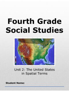
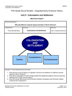
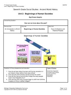
1 4th Grade United States Studies Unit 2: The United States in Spatial Terms Fourth Grade Social Studies Unit 2: The United States in Spatial Terms Student Name: 4th Grade United States Studies Unit 2: The United States in Spatial Terms Michigan Citizenship Collaborative curriculum Page 1 of 61 Big Picture Graphic Overarching Question: How does the geography of the United States affect the way people live? Previous Unit: Foundations in Social Studies This Unit: The United States in Spatial Terms Next Unit: Human Geography in the United States Questions To Focus Assessment and Instruction: 1. What questions would geographers ask in examining the United States? 2. What tools and technologies would geographers use to answer geographic questions? 3. How might the United States be described using the concepts of location, place, and regions? Types of Thinking Classifying/Grouping Compare and Contrast Evidentiary Argument Research 4th Grade United States Studies Unit 2: The United States in Spatial Terms Michigan Citizenship Collaborative curriculum Page 2 of 61 Questions for Students In this unit, we are going to be learning about the United States in spatial terms.
2 Think about the focus questions: 1. What questions would geographers ask in examining the United States? 2. What tools and technologies would geographers use to answer geographic questions? 3. How might the United States be described using the concepts of location, place, and regions? Use the chart below to write or draw about these questions. Things I Know Questions I Have 4th Grade United States Studies Unit 2: The United States in Spatial Terms Michigan Citizenship Collaborative curriculum Page 3 of 61 Lesson 1 Graphic Organizer Where is the United States located? Continent Political Boundaries Hemisphere Equator Prime Meridian Northern Hemisphere Western Hemisphere North America Mostly North of Mexico Mostly South of Canada 4th Grade United States Studies Unit 2: The United States in Spatial Terms Michigan Citizenship Collaborative curriculum Page 4 of 61 Word Cards 1 the five themes of geography five big ideas that help people understand geography Example: Location is one of the five themes of geography.
3 2 location the geographic theme that answers the question Where is it? Example: Maps can be used to find out the location of a place. 3 relative location where a place is located in relation to other places Example: The United States is located north of the country of Mexico. 4 continent one of the seven large landmasses of the Earth Example: The United States is part of the continent of North America. Big Ideas of Lesson 1, Unit 2 Location is where a place is on the Earth s surface. Geographers investigate both the absolute and relative location of places. A variety of geographic representations including maps and globes can help answer the question: Where is the United States located? The United States is located on the continent of North America. The United States is located in the Western Hemisphere of the Earth. It is also located in the Northern Hemisphere of the Earth. The equator and the Prime Meridian are used to define the hemispheres of Earth.
4 4th Grade United States Studies Unit 2: The United States in Spatial Terms Michigan Citizenship Collaborative curriculum Page 5 of 61 5 political boundaries lines that define the border of a country or state Example: There is a political boundary between the United States and Canada. 6 hemisphere a region created when the Earth is divided in half Example: The Earth can be divided into the Western Hemisphere and the Eastern Hemisphere. It can also be divided into the Northern Hemisphere and the Southern Hemisphere. 7 Equator an imaginary line that divides the Earth into Northern and Southern hemispheres Example: The United States is located north of the equator. 8 Prime Meridian an imaginary line that divides the Earth into Western and Eastern Hemispheres Example: The United States is located west of the Prime Meridian. 9 absolute location the location of a point on the Earth by use of a grid system Example: We can find the absolute location of a place by using a globe.
5 4th Grade United States Studies Unit 2: The United States in Spatial Terms Michigan Citizenship Collaborative curriculum Page 6 of 61 Questions Geographers Ask Theme Questions Location Where is it? What is its absolute location? What is its relative location? Place What is it like there? What are its natural characteristics? What are its human characteristics? Human/Environment Interaction How do people interact with the environment? How have people used the environment? How have people adapted to the environment? How have people modified or changed the environment? Movement How is the place connected to other places? How and why have people, goods, and ideas moved in and out of the place? Regions How might common geographic characteristics help us understand this place? How can the place be divided into regions? To what regions does the place belong? 4th Grade United States Studies Unit 2: The United States in Spatial Terms Michigan Citizenship Collaborative curriculum Page 7 of 61 Outline Map of North America Source: Outline Map of North America.
6 7 October 2008 < >. 4th Grade United States Studies Unit 2: The United States in Spatial Terms Michigan Citizenship Collaborative curriculum Page 8 of 61 The Northern Hemisphere Source: The Northern Hemisphere. Wikimedia Commons. 7 October 2008 < >. 4th Grade United States Studies Unit 2: The United States in Spatial Terms Michigan Citizenship Collaborative curriculum Page 9 of 61 The Western Hemisphere Source: The Western Hemisphere. Wikimedia Commons. 7 October 2008 < >. 4th Grade United States Studies Unit 2: The United States in Spatial Terms Michigan Citizenship Collaborative curriculum Page 10 of 61 Describing the Relative Location of the United States By continent Using political boundaries By hemisphere Using the equator Using the Prime Meridian Think of one more way to describe the relative location of the 4th Grade United States Studies Unit 2: The United States in Spatial Terms Michigan Citizenship Collaborative curriculum Page 11 of 61 Lesson 2 Graphic Organizer Physical Characteristics of the United States LAND desert valley mountain range plain coastal plain plateau basin canyon WATER ocean lake gulf river system 4th Grade United States Studies Unit 2: The United States in Spatial Terms Michigan Citizenship Collaborative curriculum Page 12 of 61 Word Cards Word Cards from previous lessons needed for this lesson.
7 Fundamental Themes of Geography Word Card #1 from Lesson 1 10 place the geographic theme that answers the question What is it like there? Example: Geographers use the theme of place to describe what an area is like. 11 physical characteristics geographic features that were not made by humans Example: Lakes, rivers, and mountains are physical characteristics of a place. 12 landforms different kinds of land on the Earth Example: Mountains, hills, and islands are different landforms. 13 mountain range a row of connected mountains Example: The Rockies and the Appalachian are two major mountain ranges in the United States. Big Ideas of Lesson 2, Unit 2 Place is an important theme in geography. Geographers investigate both the physical and human characteristics of a place. Physical characteristics include landforms, bodies of water, climate, and vegetation. The United States has a wide variety of physical characteristics.
8 4th Grade United States Studies Unit 2: The United States in Spatial Terms Michigan Citizenship Collaborative curriculum Page 13 of 61 14 plain low-lying stretch of flat or gently rolling land Example: The Interior Plains are located in the central part of the United States. 15 coastal plain low land that lies along an ocean Example: A coastal plain is found along the Atlantic ocean in the eastern part of the United States. 16 plateau flat land with higher elevation than a plain Example: The Ozark Plateau is an example of a plateau located in the United States. 17 basin low area surrounded by higher land Example: The Great Basin is located in the western part of the United States. 18 valley a low piece of land between two hills or mountain ranges Example: A large valley is located between the Sierra Nevada Mountains and the coastal mountains in California. 19 canyon a deep, narrow valley with step sides Example: The Grand Canyon is an important landform located in the United States.
9 4th Grade United States Studies Unit 2: The United States in Spatial Terms Michigan Citizenship Collaborative curriculum Page 14 of 61 20 desert a dry region that receives very little rain Example: The Mohave Desert and the Sonoran Desert are located in the United States. 21 vegetation the plants of an area Example: The vegetation of a desert is very different from that of a coastal plain. 22 gulf part of a sea or ocean that cuts into a mass of land Example: The United States borders the Gulf of Mexico. 23 river system a river and its tributaries Example: The Mississippi River system includes other rivers such as the Missouri River. 24 tributary a stream or river that flows into a larger stream or river Example: The Missouri River is a tributary of the Mississippi River. 4th Grade United States Studies Unit 2: The United States in Spatial Terms THIS LAND IS YOUR LAND Words and music by Woody Guthrie This land is your land, this land is my land From California, to the New York Island From the redwood forest, to the gulf stream waters This land was made for you and me As I was walking a ribbon of highway I saw above me an endless skyway I saw below me a golden valley This land was made for you and me I've roamed and rambled and I've followed my footsteps To the sparkling sands of her diamond deserts And all around me a voice was sounding This land was made for you and me The sun comes shining as I was strolling The wheat fields waving and the dust clouds rolling The fog was lifting a voice come chanting This land was made for you and me AMERICA THE BEAUTIFUL Words by Katharine Lee Bates O beautiful for spacious skies, For amber waves of grain, For purple mountain majesties Above the fruited plain!
10 America! America! God shed his grace on thee And crown thy good with brotherhood From sea to shining sea! 4th Grade United States Studies Unit 2: The United States in Spatial Terms Michigan Citizenship Collaborative curriculum Page 18 of 61 Physical Characteristics of the United StatesPhysical Characteristic Definition United States Examples mountain range a row of connected mountains plain low-lying stretch of flat or gently rolling land coastal plain low land that lies along an ocean plateau flat land with higher elevation than a plain basin low area surrounded by higher land valley a low piece of land between two hills or mountains canyon a deep, narrow valley with steep sides river system a river and its tributaries gulf part of a sea or ocean that cuts into a mass of land desert a dry region that gets very little rain 4th Grade United States Studies Unit 2: The United States in Spatial Terms Michigan Citizenship Collaborative curriculum Page 19 of 61 Digital Relief Map of the United States Source.