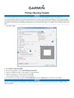
Transcription of GNS 530(A) - Garmin International
1 GNS 530(A) Pilot s Guide and ReferenceGNS 530(A) Pilot s Guide and Reference190-00181-00 Rev. HiRECORD OF REVISIONSR evisionDate of RevisionDescriptionA5/00 Initial ReleaseB5/01 Update to reflect software changes through to reflect software changes through layout, added TAWS, TERRAIN, TIS, and Weather information, per SW per Main SW Proximity Advisory info from Section 14G09/08 Converted format of figures to accommodate printing processH12/09 Added Section , GTS 8XX Traffic SystemsGNS 530(A) Pilot s Guide and Reference190-00181-00 Rev. HiiCOPYRIGHTC opyright 2009 Garmin Ltd. or its subsidiaries. All rights manual reflects the operation of Main System Software version or later. Some differences may be observed when comparing the information in this manual to other software International , Inc.
2 , 1200 East 151st Street, Olathe, Kansas 66062 USA p: f: AT, Inc., 2345 Turner Road SE, Salem, Oregon 97302 USA p: f: (Europe) Ltd., Liberty House, Bulls Copse Road, Hounsdown Business Park, Southampton, SO40 9RB, p: +44/ (0) f: +44/ (0) (Asia) Corp., No. 68, Jangshu 2nd Road., Shijr, Taipei County, Taiwan p: 886 f : 886 Site Address: the Garmin website for the latest updates and supplemental information concerning the operation of this and other Garmin as expressly provided herein, no part of this manual may be reproduced, copied, transmitted, disseminated, downloaded or stored in any storage medium, for any purpose without the express written permission of Garmin . Garmin hereby grants permission to download a single copy of this manual and of any revision to this manual onto a hard drive or other electronic storage medium to be viewed for personal use, provided that such electronic or printed copy of this manual or revision must contain the complete text of this copyright notice and provided further that any unauthorized commercial distribution of this manual or any revision hereto is strictly , AutoLocate , and PhaseTrac12 are registered trademarks of Garmin Ltd.
3 Or its subsidiaries and may not be used without the express permission of and Spell N Find are trademarks of Garmin Ltd. or its subsidiaries and may not be used without the express permission of is a registered trademark of Jeppesen, 2009 190-00181-00 Rev. H Printed in the 530(A) Pilot s Guide and Reference190-00181-00 Rev. HiiiTABLE OF CONTENTSSECTION 1: INTRODUCTION .. Accessories and Packing List .. Key and Knob Functions .. Takeoff Tour ..1-5 SECTION 2: COM .. Communicating using the gns 530 ..2-1 SECTION 3: NAV PAGES .. Main Page Groups .. NAV Page Group .. Default NAV Page .. Map Page .. TERRAIN Page .. TAWS Page .. NAV/COM Page .. Satellite Status Page ..3-23 SECTION 4: DIRECT-TO NAVIGATION .. Overview ..4-1 SECTION 5: FLIGHT Flight Plan Catalog Page.
4 Active Flight Plan Page ..5-8 SECTION 6: PROCEDURES .. Approaches, Departures, and Arrivals .. Non-Precision Approach Operations .. ILS Approaches .. Points to Remember for All 7: WPT PAGES .. WPT Page Group .. Airport Location Page .. Airport Runway Page .. Airport Frequency Page .. Airport Approach Page .. Airport Arrival Page .. Airport Departure Page .. Intersection Page .. NDB Page .. VOR Page .. User Waypoint 8: NRST PAGES .. NRST Page Group .. Nearest Airport Page .. Nearest Intersection Page .. Nearest NDB Page .. Nearest VOR Page .. Nearest User Waypoint Page .. Nearest Center (ARTCC) Page .. Nearest Flight Service Station (FSS) Page .. Nearest Airspace Page ..8-11 SECTION 9: VLOC RECEIVER .. VLOC (VOR/LOCALIZER/GLIDESLOPE) Receiver Operations.
5 9-1 SECTION 10: AUX PAGES .. AUX Page Group .. Flight Planning Page .. Utility Page .. Setup Page ..10-18 SECTION 11: VERTICAL NAVIGATION (VNAV) ..11-1 SECTION 12: TERRAIN .. INTRODUCTION .. TERRAIN Page .. TERRAIN Alerts .. Database Information for TERRAIN ..12-9 SECTION 13: TAWS .. INTRODUCTION .. TAWS Page .. TAWS Alerts .. Database Information for TAWS ..13-11 SECTION 14: ADDITIONAL FEATURES .. Traffic Information Service (TIS) Interface .. GTS 8XX Traffic Systems .. Weather Data Link Interface ..14-19 SECTION 15: FAULT DETECTION and Detection and Exclusion .. Pre-Departure Verification of FDE ..15-2 gns 530 (A) Pilot s Guide and Reference190-00181-00 Rev. HivTABLE OF CONTENTSSECTION 16: MESSAGES, ABBREVIATIONS, and NAV TERMS .. Messages .. Abbreviations.
6 Navigation Terms ..16-12 Appendix A: Data Card Use ..A-1 Appendix B: Specifications ..B-1 Appendix C: Troubleshooting Q & A ..C-1 gns 530 (A) Pilot s Guide and Reference190-00181-00 Rev. HvWARNINGS, CAUTIONS, AND NOTES WARNING: Navigation and terrain separation must NOT be predicated upon the use of the TAWS function. The TAWS feature is NOT intended to be used as a primary reference for terrain avoidance and does not relieve the pilot from the responsibility of being aware of surroundings during flight. The TAWS feature is only to be used as an aid for terrain avoidance and is not certified for use in applications requiring a certified terrain aware-ness system. Terrain data is obtained from third party sources. Garmin is not able to independently verify the accuracy of the terrain data.
7 WARNING: The terrain data should be used only as an aid for situational awareness. Terrain data must not be used as the sole basis for decisions or maneuvers to avoid terrain or obstacles. Terrain data must not be used for navigation. WARNING: The altitude calculated by gns 530 GPS receivers is geometric height above Mean Sea Level and could vary significantly from the altitude displayed by pressure altimeters in aircraft. GPS altitude should never be used for vertical navigation. Always use pressure altitude displayed by pressure altimeters in the aircraft. WARNING: The Jeppesen database used in the gns 530 system must be updated regularly in order to ensure that its information remains current. Updates are released every 28 days. A database information packet is included in the gns 530 package.
8 Pilots using an outdated database do so entirely at their own risk. WARNING: The basemap (land and water data) must not be used for navigation, but rather only for non-navigational situational awareness. Any basemap indication should be compared with other navigation sources. WARNING: For safety reasons, gns 530 operational procedures must be learned on the ground. WARNING: The United States government operates the Global Positioning System and is solely responsible for its accuracy and maintenance. The GPS system is subject to changes which could affect the accuracy and performance of all GPS equipment. Portions of the Garmin gns 530 utilize GPS as a precision electronic NAVigation AID (NAVAID). Therefore, as with all NAVAIDs, information presented by the gns 530 can be misused or misinterpreted and, therefore, become 530(A) Pilot s Guide and Reference190-00181-00 Rev.
9 HviWARNINGS, CAUTIONS, AND NOTES WARNING: Use the gns 530 , Weather Data Link Interface, TIS, and TAWS at your own risk. To reduce the risk of unsafe operation, carefully review and understand all aspects of the gns 530 Pilot s Guide documentation and the gns 530 Flight Manual Supplement. Thoroughly practice basic operation prior to actual use. During flight operations, carefully compare indications from the gns 530 to all available navigation sources, including the information from other NAVAIDs, visual sightings, charts, etc. For safety purposes, always resolve any discrepancies before continuing navigation. CAUTION: The gns 530 display lens is coated with a special anti-reflective coating that is very sensitive to skin oils, waxes, and abrasive cleaners. CLEANERS CONTAINING AMMONIA WILL HARM THE ANTI-REFLECTIVE COATING.
10 It is very important to clean the lens using a clean, lint-free cloth and an eyeglass lens cleaner that is specified as safe for anti-reflective coatings. CAUTION: The Garmin gns 530 does not contain any user-serviceable parts. Repairs should only be made by an authorized Garmin service center. Unauthorized repairs or modifications could void both the warranty and the pilot s authority to operate this device under FAA/FCC regulations. NOTE: All visual depictions contained within this document, including screen images of the gns 530 panel and displays, are subject to change and may not reflect the most current gns 530 system. Depictions of equipment may differ slightly from the actual equipment. NOTE: This device complies with part 15 of the FCC Rules. Operation is subject to the following two conditions: (1) this device may not cause harmful interference, and (2) this device must accept any interference received, including interference that may cause undesired operation.