Transcription of Graphical Area Forecast & AIRMET User Guide
1 July 2018 | Version Graphical area Forecast & AIRMET user Guide Graphical area Forecast user Guide ii Document Control Revision history VERSION DATE DESCRIPTION AUTHOR 1 15 September 2017 Final version Elizabeth Heba 13 October 2017 Update to provide clarification on AIRMETs and SIGMETs Elizabeth Heba 20 October 2017 Update to GAF samples and worked example Additional text in area Briefing (NAIPS) Section Update to abbreviation examples Ashwin Naidu 12 July 2018 Update based on user feedback Removed reference to ARFOR Expanded sub area section Expanded GPWT section Replaced GAF examples Added GPWT Reference charts Regional Aviation Team Approval for release DATE NAME Position Signature 17 July 2018 Gordon Jackson National Manager Aviation Meteorological Services Version number Date of issue Version 19 July 2018 Commonwealth of Australia 2018 This work is copyright.
2 Apart from any use as permitted under the Copyright Act 1968, no part may be reproduced without prior written permission from the Bureau of Meteorology. Requests and inquiries concerning reproduction and rights should be addressed to the Production Manager, Communication Section, Bureau of Meteorology, GPO Box 1289, Melbourne 3001. Information regarding requests for reproduction of material from the Bureau website can be found at Graphical area Forecast & AIRMET user Guide iii Table of Contents 1 Purpose .. 7 2 Introduction .. 8 3 Graphical area Forecast Layout .. 14 Product Layout .. 14 Header .. 14 Image .. 14 Table .. 15 Legend .. 15 Remarks .. 15 4 Graphical area Forecast Content .. 16 Times of Issuance and Periods of Validity .. 16 Image .. 16 Meteorological Information Table .. 17 Column 1: area .. 19 Column 2: Surface Visibility and Weather .. 19 Column 3: Cloud, Icing and Turbulence.
3 19 Column 4: Freezing Level .. 22 Prevailing Conditions .. 22 Use of Sub Areas .. 23 Critical Locations .. 26 Weather 27 Visibility Information .. 27 Cloud information .. 27 Additional Information .. 27 GAF Worked Example .. 28 5 Changes to GAF and Corrected GAF .. 31 Corrections .. 31 Corrected GAF Worked Example .. 33 6 AIRMET .. 36 Issuance .. 36 Extension .. 37 Cancellation .. 38 7 Grid Point Wind and Temperature Forecasts .. 41 Introduction .. 41 Layout .. 41 Domain .. 42 Product Format .. 43 Graphical area Forecast user Guide iv Issue Times and Validity Periods .. 43 Deconstructing Low-level GPWT Forecast Charts .. 44 GPWT Reference Charts .. 45 GPWT Caveats .. 46 8 Briefing & Product Output .. 49 Product Output Format .. 49 area Briefing (NAIPS) .. 49 APPENDIX A GAF Units Used .. 52 APPENDIX B Approved Abbreviations/Terms .. 53 APPENDIX C Approved Symbols.
4 60 APPENDIX D GAF Worked Examples .. 61 APPENDIX E Corrected GAF Examples .. 65 APPENDIX F Using GPWT Forecasts .. 67 APPENDIX G Using Two GPWT Forecasts .. 69 APPENDIX H Obtaining Freezing Level .. 71 APPENDIX I GPWT Reference Charts .. 74 Graphical area Forecast & AIRMET user Guide v List of Tables Table 1 Approved cloud amount abbreviations .. 20 Table 2 Approved CB and TCU cloud amount, and thunderstorm coverage abbreviations .. 21 Table 3 Critical location information .. 27 Table 4 Criteria for GAF correction for an improvement in conditions .. 32 Table 5 Criteria for issuance of AIRMETs .. 36 Table 6 Issue and Validity Times of Low Level GPWT Charts .. 44 Table 7 Explanation of data box format .. 45 Table 8 Approved Abbreviations and Terms .. 59 Table 9 Approved symbols .. 60 Table 10 Wind and Temperature data for example flight .. 67 Table 11 Grid Point Wind and Temperature data for example flight from YMLT to YKII.
5 70 List of Figures Figure 1 Graphical area Forecast for 9 Figure 2 Graphical area Forecast boundaries .. 10 Figure 3 Grid Point Wind Temperature Forecast (VIC/TAS) .. 11 Figure 4 Grid Point Wind Temperature Forecast Areas .. 12 Figure 5 Product Layout .. 14 Figure 6 GAF validity and issue times .. 16 Figure 7 GAF Image .. 17 Figure 8 Meteorological Information Table .. 18 Figure 9 QLD-N GAF Valid 2300-0500Z .. 24 Figure 10 NSW-W GAF Valid 0500-1100Z .. 24 Figure 11 New South Wales West GAF .. 28 Figure 12 Corrected GAF Header .. 32 Figure 13 SA GAF .. 33 Figure 14 CORRECTED SA GAF .. 34 Figure 15 AIRMET cancellation example .. 38 Figure 16 NSW Low-level GPWT Forecast .. 42 Figure 17 Low-level GPWT Forecast boundaries .. 43 Figure 18 Low Level GPWT chart legend .. 44 Figure 19 Example of grid box from GPWT chart .. 45 Figure 20 NSW GPWT Reference Chart .. 46 Figure 21 GPWT QLD-N example.
6 47 Figure 22 NAIPS Briefing / area QNH Boundaries .. 49 Figure 23 NAIPS area Briefing selection page .. 50 Figure 24 GAF for Northern Territory .. 61 Figure 25 GAF for Victoria .. 63 Figure 26 Corrected QLD-S GAF .. 65 Figure 27 Corrected WA-N GAF .. 65 Graphical area Forecast user Guide vi Figure 28 Corrected TAS GAF .. 66 Figure 29 Example Flight .. 67 Figure 30 Extract from VT GPWT Forecast chart valid at 0600 UTC .. 69 Figure 31 Extract from VT GPWT Forecast chart valid at 0900 UTC .. 69 Figure 32 WA-S GAF .. 71 Figure 33 WA-S GPWT Forecast chart .. 72 Figure 34 Subset of WA-S GPWT Forecast chart grid boxes .. 72 Figure 35 Mid-level SIGWX Forecast chart .. 73 Figure 36 Low-level NSW GPWT Reference Chart ( grids) .. 74 Figure 37 Low-level QLD-S GPWT Reference Chart ( grids) .. 74 Figure 38 Low-level NT GPWT Reference Chart ( grids) .. 75 Figure 39 Low-level SA GPWT Reference Chart ( grids).
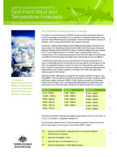
7 76 Figure 40 Low-level Vic/Tas GPWT Reference Chart ( grids) .. 77 Figure 41 Low-level WA-N GPWT Reference Chart ( grids) .. 78 Figure 42 Low-level WA-S GPWT Reference Chart ( grids) .. 78 Figure 43 Low-level QLD-N GPWT Reference Chart ( grids) .. 79 Graphical area Forecast & AIRMET user Guide 7 1 Purpose The Graphical area Forecast (GAF) user Guide , incorporates AIRMET information and provides detailed information on the Graphical area Forecast (GAF), Grid Point Wind and Temperature (GPWT) Forecast and AIRMET product. It highlights the purpose of these products and details information on how to interpret them. This document also highlights the relationship of these products to other related aviation products and services, including SIGMETs, area QNH, Mid-Level Significant Weather (SIG WX) Forecast charts and Mid-Level GPWT Forecast charts. Graphical area Forecast user Guide 8 2 Introduction Graphical area Forecast (GAF), Low-level Grid Point Wind and Temperature (GPWT) Forecast and AIRMET advice are designed primarily to meet the needs of pilots flying in the airspace between the surface and 10,000 feet above mean sea level (AMSL).
8 GAF (Figure 1) provides information on weather, cloud, visibility, icing, turbulence and freezing level in a Graphical layout with supporting text. These are produced for 10 areas across Australia (green boundaries in Figure 2), broadly State-based. These GAF areas are named as NSW-E, NSW-W, NT, QLD-N, QLD-S, SA, VIC, TAS, WA-S and, WA-N.; Low-Level GPWT Forecast (termed as GPWT Forecast in this document) provides wind speed and direction and temperature forecasts at specified heights AMSL presented in a gridded format (Figure 3). GPWT Forecast are produced for nine areas across Australia covering the GAF areas and a specific Timor Sea area (as in Figure 4). These GPWT areas are named as AUS, NSW, NT, QLD-N, QLD-S, SA, TIMS, VT (VIC/TAS), WA-S and, WA-N; and An AIRMET advice is complimentary to the routine issue of the GAF and provides information on the occurrence and/or expected occurrence of specified meteorological phenomena that are not included within a valid GAF.
9 Graphical area Forecast & AIRMET user Guide 9 Figure 1 Graphical area Forecast for Victoria Graphical area Forecast user Guide 10 Figure 2 Graphical area Forecast boundaries Graphical area Forecast & AIRMET user Guide 11 Figure 3 Grid Point Wind Temperature Forecast (VIC/TAS) Graphical area Forecast user Guide 12 Figure 4 Grid Point Wind Temperature Forecast Areas Graphical area Forecast & AIRMET user Guide 13 Graphical area Forecast user Guide 14 3 Graphical area Forecast Layout Product Layout Figure 5 Product Layout Header The header field contains the title of the product, GAF area name, issue time, validity times (given in UTC time), validity time of any weather features and the Bureau of Meteorology logo. The word CORRECTED will also be included if the GAF has been corrected (see section ). Image The image is derived from the Airservices Planning Chart Australia (PCA) chart, with the boundary of the GAF area , or limit of the Forecast area , overlayed in black.
10 Note, not all PCA locations are displayed due to the size of the image. The image shows weather areas that are labelled with an alpha character (such as A, B, etc.), with alphanumeric labels (such as A1 or B1) highlighting a sub- area . The green scalloped lines separate the areas and sub areas. Weather features, such as cold fronts, troughs, lows and Tropical Cyclones can be displayed with their movement depicted using an arrow and their speed of movement given in knots. Graphical area Forecast & AIRMET user Guide 15 Table Meteorological information is provided in a tabular format and is separated into areas. The area alpha character is displayed in the first column, surface visibility and weather are displayed in the second column, the third column displays the cloud, icing and turbulence information, and the fourth and final column details the freezing level. Legend The legend specifies the following: TS/CB/TCU will always imply severe icing and severe turbulence; CU/SC/AC will always imply moderate turbulence; cloud above the Freezing Level (CLD ABV FZLVL) will always imply moderate icing; alerts the user to check AIRMETs, SIGMETs and NOTAMs; highlights that critical locations on the map are marked by a different colour and larger dot; speed of movement of weather features, such as fronts, troughs and low-pressure systems, are in knots.