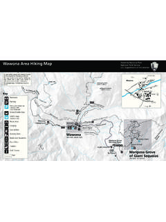
Transcription of Great Smoky Mountains G - National Park Service
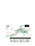
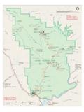
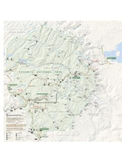
1 00110 Miles10 Kilometers1 North40404014314341628282832327373731974 7419237423191291294414414414412763213214 11441441321441321321411321321129411129 Mountains -To-SeaTrailBentonMacKayeTrailB entonMacKayeTrail Great Smoky Mountains National PARK333231213053686970646567747598767781 8688858490919395921214151171621135689969 7826362605958565452282627181920353940344 44849410042 AppalachianTrailAppalachianTrailAppalach ianTrailAppalachian Trail00877873726636382950242310913113615 55771834737 DavenportGapLaurel GapCosbyKnobTricorner KnobPecks CornerMount Le ConteCampfires ProhibitedIcewaterSpringKephartMount CollinsDouble SpringGapSilers BaldDerrickKnobRockyTopSpence FieldRussell FieldMollies Ridge00 ForneyCreekPigeonRiverWATERVILLELAKEBigC reekCataloocheeCreekJonathanCreekTuckase geeRiverSocoCreekIndianCreekFa llsRamseyCascadesGrottoFallsLa urel FallsAbramsFallsThe SinksRainbowFa llsHen Wallow FallsRavenForkOconalufteeRiverRavenForkB radleyForkCosbyCreekLittlePigeonRiverMid dleProngLittlePigeonRiverWestProngLittle PigeonRiverWProngLittlePigeonRiverNoland CreekTuckasegeeRiverLittleTennesseeRiver DeepCreekCoveCreekLittleRiverMiddleProng LittleRiverHazelCreekFONTANALAKEN antahalaRiverSANTEETLAH LAKEC heoahRiverLAKECHEOAHE agleCreekCALDERWOODLAKECHILHOWEELAKETENN ESSEERIVERL ittleRiverLittleRiverAbramsCreekAbramsCr eekTENNESSEENORTH CAROLINATENNESSEENORTH CAROLINATENNESSEENORTH GroveLoop Tr KnobAlbright GroveMount TrailGoshenProngTrailMiryRidgeTrailLumbe rRidgeTrailMeigsMountainTrailJakesCreekT railPantherCreekTrLynnCampProngTrWestPro ngTrBlanketMountainCold SpringKnobBuckeye GapJa kesGapSweatHeiferCrTrailRoadProngTrailNe wfound ttle
2 GreenbrierSchoolRoundtopTrailLaurelFalls TrailLittleRiverRoadChestnutTopTrailMeig sCreekTrCurryMtnTrailScottMtnTrLi ttleGreenbrierTrailLi ttleBrierGap Tr MetcalfBottoms TrTurkeypenRidgeTrSchoolhouse Gap Trail RichMtnTrIndianGraveGapTrCrookedArmRi dge wnsendVi sitors (closedinwinter)RichMountainRdCadesCoveL oopRoadRich MtnLoop TrRICHMTNCADES COVEF orgeCreekRoadBOTEMTNG regoryBaldTrailLongHungryRidgeTrailGrego ryRidgeTrailHannahMountainTrailParsonBra nchRoad(closedinwinter)(closedinwinter) GapGregoryBaldParsonBaldDoe TrGoldmineLoopTrailTunnelBypassTrailHigh RocksCold DomeBypass TrailClingmansDomeRoad(closedinwinter) towerAuto-access horse campHiker only campsite Shelter (Hiker only)Shelter (Horse and hiker)Horse and hiker campsit e Boat-in only campsite Ranger stationDeveloped campgroundHiking only (top)Horse and hikingUnpaved roadHiking trailHorse and hiking trailTrail distances are shown in miles be-tween intersectionsMountains-To-SeaTrailBenton MacKayeTrailRoads in park are closedto commercial ValleyWAYNESVILLESoco GapTo AshevilleTo AshevillePl ott BalsamWaterrock KnobBlueRidgeParkwayOLDBALDRIDGEPLOTTBAL SAMSP olls GapBlack Camp GapCATALOOCHEEDIVIDE(closedinwinter)NANT AHALA National FORESTTo AtlantaWesserStecoah GapCheoah BaldNANTAHALAMOUNTAINSROBBINSVILLESNOWBI RDMOUNTAINSFONTANAVI LLAGEYELLOWCREEKMOUNTAINSJOYCE KILMER - SLICKROCKWILDERNESS AREATheCherohalaScenicSkywayCHEROKEENATI ONAL FORESTF ontanaMarinaFontanaDamBRYSON CITYL akeviewDriveDeep CreekJuney WhankFa lls TrailDeep Creek Horse TrailStone PileGap INDIAN RESERVATION(Qualla Boundary)
3 CHEROKEEO conalufteeVisitor Center Oconaluftee River Trail HighlandsScience Learning CenterBalsam MountainBlueRidgeParkwayHemphillBaldTrRo ughForkTrailCataloocheeDivideTrailBooger manTrailCaldwellForkTrailHeintoogaRidgeR oadFlatCreekTrBigFkRidgeTrMcKeeBrTrSpruc e MountainTrailBalsamMountainRdSpruce MountainDouble GapPurchase Gap(closedinwinter) n OakGapBALSAMMOUNTAINN ewtonBaldHUGHESRIDGERICHLANDMOUNTAINTHOM ASRIDGEP almerCreekTrailChasteenCreekTrSmokemontT ow StringRound CoveVisitor CenterChilhoweeFoothillsParkwayHappyVall eyRoadCHILHOWEEMOUNTAINA brams CreekGold MineTrailLook RockTo ChattanoogaFoothillsParkwayTownsendWalla ndTUCKALEECHEECOVEE lkmontHuskey GapFi ghtingCreekGapGreat Smoky MountainsInstitute at TremontWear ValleyWEARCOVES ugarlandsVisitor CenterPark HeadquartersGATLINBURGB alsamPoint(closedinwinter)CherokeeOrchar dRdone-wayLa urel TopAlum SequoyahMount GuyotBalsamHigh Sterling GapPretty Hollow GapMountSterlingCove Creek GapLow KnoxvilleMcGhee-TysonAirportTo KnoxvilleCHILHOWEEMOUNTAINSEVIERVILLEPI GEON FORGEG atlinburg Welcome CenterNational park Information CenterCOVEMOUNTAING atlinburg Bypass RoadPittmanCenterWEBBMOUNTAINTo NewportExit443 CosbyCosbyTo NewportCamel GapFoothillsParkway(closedinwinter)MtCam mererCHEROKEE National FORESTExit 451 WatervilleBi g all park trails cross small streams making very wet crossings during flooding.
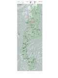
4 The following trails that cross streams with no bridges Many areas of the park , including roads, frontcountry campgrounds, trails, and backcountry campsites/shelters are subject to closure asenvironmental conditions or operational capabilities change. Pleasecheck the park s website at for the latest closure be difficult and dangerous at flood stage. (Asterisks ** indicate the most difficult and potentially dangerous.) This list is not Cane Trail near campsite #3 Beech Gap Trail on Straight Fork RoadCold Spring Gap Trail at Hazel Creek Eagle Creek Trail** 15 crossingsFork Ridge Trailcrossing of Deep Creek at junction with Deep Creek TrailForney Creek Trail** seven crossingsGunter Fork Trail** five crossingsHannah mountain Trail** just before Abrams Falls TrailJonas Creek Trail near Forney CreekLittle River Trail near campsite #30 Long Hungry Ridge Trail both sides of campsite #92 Lost Cove Trail near Lakeshore Trail junctionMeigs Creek Trail 18 crossingsNoland Creek Trail** both sides of campsite #62 Panther Creek Trail at Middle Prong Trail junctionPole Road Creek Trail near Deep Creek TrailRabbit Creek Trail at the Abrams Falls TrailheadRoundtop Trail** crossing of Little River at Little River Road Trillium Gap Trail at Grotto Falls (icy in winter)
5 Upper Hazel Creek Trail hiker-only portionWet Bottom Trailfollow signs for Elijah Oliver Trail as alternate routeStream CrossingsFacility ClosuresMAP LEGEND123456789101112123456789101112 ABCDEFGHIABCDEFGH12345678910111212345678 9101112 Great Smoky MountainsTrail MapNational park Department of the InteriorGreat Smoky MountainsNational ParkNorth Carolina/Tennessee450036 802510$ Den Ridge Gabes mountain TrLower Mount Cammerer TrLow Loop TrBradley ForkTowstring TrNewton Bald TrThis trail map is not intended to show legal boundary of the National Your SafetyDo not leave valuables in sight inside your car. Do not leave a note on your car indicating how long you will be hiking. Protect your valuables by taking them with you or hiding them in your car. Leave No TraceYour personal commitment to ethical backcountry use is the most important factor in maintaining the park 's wilder-ness character.
6 Take pride in leaving no trace of your presence here. Abide by all backcountry use regulations. They are designed for resource protection. Use a stove and candle lantern to minimize the tram-pling and destruction of vegetation that result from collecting firewood. Never cook or burn food in a campfire. Food residues and odors remain and attract wildlife that will become a problem for future campers. Keep your group small to preserve a sense of solitude. Camp where your campsite already shows impacts. Don't establish new tent sites. Pack out all leftover food and trash. Avoid cutting across switch-backs, to prevent destructive trail You Get LostStay calm, do not leave the trail and do not travel at night. Prevent getting lost by keeping your group together, staying on the trail, and using a map. Let someone know your sched-ule and travel plans, so they can notify park authoritiesif you are UseImproper human waste disposal creates one of the most disgusting conditions in the backcountry.
7 Regula-tions require that human feces be deposited in a six-inch-deep hole and covered with soil. No toilet use may occur within 100 feet of a camp or water source or within sight of a trail. Defecating behind a shelter or near a spring creates very unhealthy conditions and is clearly bad manners. All toilet paper, sanitary napkins, and tampons must be packed out. Do not bury them. Please, take a little extra care!Into the Wild: Visiting the Smokies BackcountryTrip Planning and PermitsIf Someone Gets InjuredIf someone is injured and can't be moved to a trailhead, do the following: Provide warmth and comfort; leave someone with the injured person; note the exact location and circumstances; and hike out and let rescuers know where to go and what to prepare is your responsibility to make sure you don't get injured. Be careful and use common sense. Getting accident victims out of the backcountry is difficult and often dangerous for all are no cellular phone towers in the park so cell phones do not work from most locations.
8 The tops of high ridges near the park boundary are the most likely spots for reception. For emergencies only, call 911 or (865) 436 !Wind. High winds associated with approaching weather fronts can bring down trees and limbs on heavily forest-ed trails. Plan Hypothermia is when body temperature falls below the point at which the body can maintain its own heat. It is an all-season killer and results from exposure to a combination of wind, rain, and cold. At higher elevations, a wet hiker can succumb to hypothermia in mid-summer. Be prepared for sudden weather chang-es and learn how to take care of yourself in extremes of cold, heat, and wetness. Always carry raingear; storms arise quickly. Hypothermia symptoms can appear very rapidly, even in mild its symptoms and treat them immediately: uncontrolled shivering, slurred speech, memory lapses, stum-bling, fumbling hands, drowsiness, and the inability to get up after a nap.
9 Victims need dry clothing, warm fluids if conscious, and shelter from the elements. To prevent hypothermia, drink before thirsty, eat before hungry, rest before tired, and stay dry. Travel and stay with a companion. Two people can look after each other better than one can look after oneself! Clothing should be worn in layers, an outer layer to ward off wind and precipitation and inner layers to insulate. Keep your head warm and dry with a good hat. Other cold weather hazards include frostbite, icy trails, and deep crossings and waterfalls. Rain swollen streams can be unsafe to ford. Don't cross a stream unless you are sure you can make it. As an additional precaution, make sure your pack can be discarded quickly, wear shoes to protect your feet, use a stout stick for extra support, and, if you lose your footing, float with your feet downstream to protect your head.
10 Walking near a stream on moss- and spray-covered rocks can be hazardous. Never camp next to a stream swollen by high water. Water-falls can be extremely hazardous; climbing on them has resulted in many water. All water obtained in the backcountry should be treated before drinking to protect you from health hazards. The recommended treatment is to boil it for one minute. Many park waters are clear, cold, and free-running. Nevertheless, they may not be safe to drink unless boiled. Filters may not remove certain bacteria or viruses, and chemical disinfectants require very long contact times for the water temperatures found in these Mountains . Do not drink untreated water!Trees and Limbs. Before you set up camp, take a moment to look up and around you for any trees or limbs that may pose a hazard. Camp away from any areas that may be threatened by tree or limb Equipment ConcernsClothing.