Transcription of HANDBOOK FOR MCAS CHERRY POINT
1 19 Nov 14 PILOT'S HANDBOOK FOR MCAS CHERRY POINT Provided by the Air Traffic Control Facility ATCFO - Maj Jose R. Hernandez DSN 582-4664 NCOIC - MSgt Marshall K. Crawford DSN 582-4146 FAX- DSN 582-3465 NOTES _____ _____ _____ _____ _____ _____ _____ _____ _____ _____ _____ _____ _____ _____ _____ _____ _____ _____ _____ _____ _____ MCAS CHERRY POINT PILOT INFORMATION HANDOUT 1. PURPOSE. To provide aircrews with a ready reference for procedures, scheduling, use and restrictions within Special Use Airspace.
2 This handout also provides airport information, NAVAIDS and frequencies for MCAS CHERRY POINT and the local flying area. 2. INFORMATION: This handout is informational and not directive in nature. Definite authority for the procedures outlined herein is contained in the CHERRY POINT Airfield Operations Manual (AirStaO ) and the Targets Manual (AirStaO ). 3. POINT OF CONTACT: Questions regarding the information contained herein may be directed to the MCAS CHERRY POINT ATC Facility Officer or the ATC Facility Watch Officer, 466-4146. The ATC Facility may also be contacted through the Operations Duty Officer, 466-2233. RESTRICTED AREA 5306A (R-5306A) SCHEDULING: The Commanding General, MCAS CHERRY POINT , delegated the scheduling authority of R-5306A to the Central Scheduling Division, 466-4040/4041.
3 This scheduling authority includes the targets and Military Training Routes (MTRs) for which MCAS CHERRY POINT is the originating authority. Scheduling R-5306A for exclusive use requires approval of Commanding General, 2d MAW (G-3 Ops) and Commanding General, MCAS CHERRY POINT (DirOps). USE OF R-5306A: Unless otherwise scheduled, military operations within R-5306A shall be on a VFR concurrent use basis. Extreme vigilance shall be maintained as numerous military and civilian aircraft use these areas concurrently. All participating aircraft shall contact APPROACH ( ) prior to entering or exiting R-5306A. Once established within the restricted area, the pilot shall contact Big Rock on and is responsible for the conduct of the mission, squawking the assigned code and remaining within the approved area of operation.
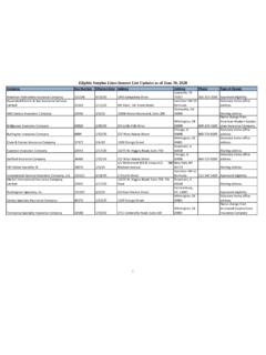
4 The following restrictions apply when operating within the restricted area. 1. Aircraft, except those scheduled to use BT-9 or BT-11, shall remain outside of a five nautical mile radius from the center of either target. 2. R-5306A is divided into sub-areas. Pilots using this restricted area shall be familiar with the sub-areas and procedures. Authorization to fly in the following sub-areas must be requested from Big Rock by area name. DIVERT AIRPORTS AND FREQUENCIES AIRPORT/FREQUENCIES LONGEST RUNWAY NAS Oceana (NTU) App Tower 5/23 11,997 X 200 NAS Norfolk (NGU) App Tower 10/28 8,369 X 200 Myrtle Beach Intl (MYR) App Tower 17/35 9,502 X 150 Wilmington Intl (ILM) App Tower 6/24 7,999 X 200 MCALF Bogue (NJM) Tower 5/23 4,010 X 96 MCAS New River (NCA) App Tower 5/23 5,115 X 150 Seymour Johnson AFB (GSB) App Tower 8/26 11,758 X 300 NAVAID FREQUENCIES NKT TACAN CH 75 NCA TACAN CH 101 ILM VORTAC CH 117 NGU TACAN CH 48 NTU TACAN CH 113 CRE VORTAC (serves MYR)
5 CH 123 CHS VORTAC CH 82 NJM TACAN CH 67 NKT ILS CH 26 CHERRY POINT FREQUENCIES RADAR TOWER Approach East Local Control Departure Ground Approach North Clearance Delivery Range Control (Big Rock) (monitor only while working Restricted Areas) ATIS Arrival METRO Base Ops ADJACENT FACILITY FREQUENCIES FACILITY UHF VHF WASHINGTON CENTER SAMPSON LO ILM APPROACH ORF APPROACH BLACKBURN NVF (GIANTKILLER) GSB APPROACH South North South North NCA RADAR a. SUB-AREA 1: That portion of R-5306A from 1000 feet to 3100 feet MSL within 15NM of CHERRY POINT TACAN. This area is used for radar approaches to runway 23R at CHERRY POINT and instrument approaches to Michael J.
6 Smith Airport. AREA 11000-3100 WITHIN 15 DME b. SUB-AREA 3A: That portion of R-5306A below 750 feet MSL located Southeast of the center of the neuse River on the CHERRY POINT TACAN 069 radial, not including the area within 5NM of BT-11. This area is used periodically by North Carolina Wildlife, North Carolina Division of Fisheries and Oceanographic Agency, crop dusters and Weyerhauser. This area will be assigned on a first come, first served basis between military and civil users. c. SUB-AREA 3B: That portion of R-5306A below 750 feet MSL located Northwest of the center of the neuse River on the CHERRY POINT TACAN 069 radial, not including the area within 5NM of BT-9 or BT-11.
7 This area is used periodically by North Carolina Wildlife, North Carolina Division of Fisheries and Oceanographic Agency, crop dusters and Weyerhauser. This area will be assigned on a first come, first served basis between military and civil users. AIRFIELD DIAGRAM SUB-AREA 3 ABELOW 750 MSLSUB-AREA 3 BBELOW 750 MSLEMERGENCY PROCEDURES Pilots confronted with an emergency should give as much of the following information as possible: CALL SIGN NATURE OF EMERGENCY TYPE AIRCRAFT POSITION, HEADING AND ALTITUDE INTENTIONS PERSONS ON BOARD FUEL REMAINING ORDNANCE ON BOARD EMERGENCY INFORMATION PLANNED EJECTION AREA NKT 078/022 BT-11 ( POINT of Marsh), heading 065 ORDNANCE JETTISON AREA NKT 057 BT-9 (Brant Island) FUEL JETTISON 6000 feet or more above terrain d.
8 OPEN GROUNDS FARM: Located in the southern portion of Sub-area 3A, where crop dusting is conducted below 300 feet. Military aircraft authorized to operate in Sub-area 3A below 750 feet MSL shall avoid this area (below 500 feet) when advised that crop dusting is in progress. e. LOW LANDS: That area over land within Sub-area 3B, where crop dusting is conducted below 300 feet. Military aircraft authorized to operate in Sub-area 3B below 750 feet MSL shall avoid this area (below 500 feet) when advised it is in use. LOWLANDSBELOW 500 f. JACKSON CORRIDOR: That area within Sub-area 3A, below 750 feet MSL from the center of the Jackson airport on a heading of 160 degrees magnetic terminating at the boundary of R-5306A, one mile wide.
9 Military aircraft shall avoid this area when advised it is in use. g. BAYBORO CORRIDOR: That area within R-5306A below 750 feet AGL within a 2NM radius of the center of the Bayboro Airport with a 3NM extension to the West, the Northern and Southern boundary of which is 1 NM from and parallel to State Highway 55 terminating at the boundary of R-5306A. Aircraft shall avoid this area at all times. FLIGHT PLAN INFORMATION Altitude: VFR Odd altitude +500 at or below 170 outbound Even altitude +500 at or below 170 inbound IFR Odd altitude at or below 170 outbound Even altitude at or below 170 inbound Route: Pilots must file from NKT to POINT Alpha (NKT 134/027) or POINT Bravo (NKT 184/016) First line of flight plan: Enter either NKT134027 or NKT184016 and the delay time.
10 (Example: D1+30) Second line of flight plan: Enter departure POINT from the warning area (same as entry POINT ) POINT OF DEPARTURE PROPOSED DEPARTURE TIME(Z) ALTITUDE ROUTE OF FLIGHT TO ETE NKT 2100 050 NKT134027 W-122/D1+30 0+15 NKT134027 2245 060 NKT 0+15 LOST COMMUNICATION "If no transmissions received for one minute in the pattern or (five/fifteen) seconds on final approach, attempt contact CHERRY POINT Approach and proceed VFR. If unable, proceed to TARHL DME fix, maintain last assigned altitude, proceed with TACAN Runway 32L approach (circle runway ____)" Contact Approach to a Pad Without a waiver from FAA directives, the only way to transition from a precision approach to a VSTOL Pad in IFR conditions is for the pilot to specifically request a Contact Approach.