Transcription of Hawksbill Area - Shenandoah National Park US Department …
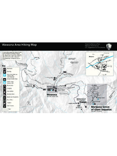
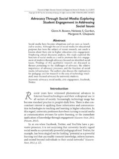
1 10/2020 Hawksbill area - Shenandoah National ParkA map of the Hawksbill area in Shenandoah National Park, Kilometer0 PPPMP45MP46MP48MP47 Spitler KnollOverlookOld Rag ViewOverlookRock Spring Cabin ParkingRock Spring CabinRock Spring HutRock Spring Access Road(no vehicle access)Skyland-Big MeadowsHorse Tr ailUpper Hawksbill TrailSalamander TrailByrds Nest 2 Shelter(day use only)Lower Hawksbill TrailCrescent RockOverlookWhiteoak CanyonFire RoadCrescent Rock TrailUpperHawksbill ParkingHawksbillViewing PlatformNorth Hawksbill Gap ParkingSkyland Big Meadows Horse TrailCedar Run TrailEmergency 1-800-732-0911 Information 540-999-3500 Online Hiking Trail Hiking Trail (Appalachian Trail) Hiking Trail (Horses)
2 Unpaved Road Paved Road Skyline DriveP Parking Building SummitNational Park Department of the InteriorHawksbill Loop Hike circuit 2-hours hiking time Moderate 860-foot elevation gainFrom the north end of the Hawksbill Gap parking area at mile , take the short connector trail to the Appalachian Trail ( ). At the trail post, turn left onto the south. Continue on the south to the trail post indicating the Salamander Trail. Go left onto the blue-blazed Salamander Trail. At the next trail junction, turn left onto the Upper Hawksbill Trail.
3 Be sure to take the short trail past the shelter to the viewing platform. To return to the parking area be sure to take the blue-blazed Lower (NOT the Upper) Hawksbill Summit Hike round trip hiking time Moderate 690-foot elevation gainFor a shorter, but steeper, rockier route, from the Hawksbill Gap parking area at mile , take the Lower Hawksbill Trail to Byrds Nest 2 Shelter and then follow the trail to the viewing platform. Retrace your steps to return to starting Hawksbill to Hawksbill Summit Hike round trip hiking time Easiest 520-foot elevation gainFrom the Upper Hawksbill parking area at mile , take the Upper Hawksbill Trail to Byrds Nest 2 Shelter and then follow the trail to the viewing platform.
4 Retrace your steps to return. Hiking Difficulty ScaleEasiest: Generally suitable for anyone who enjoys walking. Mostly level or with a slight incline. Generally less than 3 miles. Moderate: Generally suitable for novice hikers seeking a bit of a challenge. The terrain will involve a moderate incline and may have some steeper sections. Generally 3 to 5 miles. Moderately Strenuous: Generally challenging for an unconditioned person. The terrain will involve a steady and often steep incline. Generally 5 to 8 miles. Strenuous: Will challenge most hikers.
5 The hike will generally be longer and steeper, but may be deemed strenuous because of the elevation gain. Generally 7 to 10 miles. Very Strenuous: Only well-conditioned and well-prepared hikers should attempt. Generally long and steep, and may include rock scrambling, stream crossings, and other challenging terrain. Generally 8 miles and & BlazesTrail markers are at trailheads and intersections. The metal bands are stamped with directional and mileage information. Trail blazes are found on trees and rocks throughout the Park.
6 The color identifies the trail type:Blue - Hiking trailWhite - Appalachian TrailYellow - Open to horsesNeed to Know Pets must be on a leash no longer than 6 feet at all times. Take plenty of water at least a quart per hour. When you return from your hike, check for ticks. Be aware that you are in snake habitat. Be sure someone knows where you are and when to expect your return. Cell and GPS services are to KnowMany of Shenandoah s most popular views are from rocky outcrops like Hawksbill . Did you know that these popular spots are also home to some of the Park s most rare and sensitive vegetation?
7 Look closely to see these tough, yet fragile plants they look like they are growing right out of the rocks! Constant trampling puts this rare vegetation at risk, so please be aware of these special plants we are working to to KnowHawksbill is Shenandoah s highest peak at 4,051 ft. Be sure to see the view from the observation platform just a few feet up the trail from the shelter. How far you can see will depend on a number of factors including the current air quality. It s a great reminder of the simple things we can all do to reduce emissions and improve air quality not just for the views, but also for our health!
8 Leave No Trace Plan ahead and prepare. Travel and camp on durable surfaces. Dispose of waste properly. Leave what you find. Respect wildlife. Be considerate of other maintenance and map funded by recreation fee dollars.