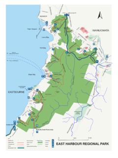
Transcription of hazard maps FINAL PRINT - GW
1 Earthquake hazard mitigation MeasuresHazardEffect on groundEffect on facilitiesMitigation options: existing facilitiesMitigation options: planned facilitiesFault movementGround disturbances vertically and horizontally over a zone depends on depth to rock below surface. Cracks in land , tearing apart, movement of foundations, severe damage to structures which cross the Assess Options:a) strengthen to surviveb) move facilities from fault zonec) limit damage by providing weak links or isolation1. Assess Options:a) construct facilities elsewhereb) incorporate special strengtheningc) provide weak links or special isolation to limit damageGround shakingViolent horizontal and vertical motions for up to one minute , fracture, collapse of buildings.
2 Breaks in underground services. Deformation of surface Assess Options:a) strengthen or base isolateb) secure/improve vulnerable partsc) limit damage by providing weak links or Assess Options:a) comply with current codes for design and constructionb) incorporate strength and resiliencec) secure vulnerable parts and contentsLiquefactionShaking causes some soils to behave like liquid, causing loss of support to structures above. Such soils may be up to 10m below ground surface. Lateral movement of large soil masses, especially adjacent to rivers. Variable subsidence of ground and tilting of structures supported on liquefi ed material. Severe damage to underground services.
3 Flotation of empty underground tanks and Assess Options:a) install pilesb) install gravel drainsc) drain liquefi able layersd) prepare for quick reinstatement1. Assess Options:a) compact ground at siteb) install piles and gravel drainsc) drain liquefi able layersSlope failureA signifi cant soil masses moves bodily down the slope, from few hundred millimetres to many metres. Landslides occur at many different from deformation of foundations and structural failures to total destruction of site and all buildings and infrastructure above and below Assess Options:a) stabilise slope retaining wallsb) stabilise slope ground anchorsc) improve drainage, reduce erosion1.
4 Assess Options:a) fi nd a better siteb) stabilise slope retaining wallsc) stabilise slope ground anchorsd) improve drainage, reduce erosionTsunamiLand fl ooded. Scouring action erodes soil dramaticallyFlooding of basements. Undermining/destruction of surface infrastructure. Exposure/damage to underground services. Undermining of foundations. Bodily movement of some structures, equipment, vehicles Assess Options:a) construct protective sea wallsb) shift critical facilities to higher level1. Assess Options:a) fi nd a better siteb) construct protective sea wallsc) design special foundations / dikesd) put critical facilities at high levelBackground statementIn recognition of the earthquake hazard in the Region, the Greater Wellington Regional Council has carried out studies on ground surface rupture from active faulting, ground shaking, liquefaction potential and associated ground damage, slope failure and tsunami inundation (Wellington Harbour).
5 Single factor hazard maps have been produced by Greater Wellington for each of these earthquake map sheet is part of a series of four map sheets showing the combined earthquake hazard for the main urban areas in the western part of the Wellington Region. The map series is one of Greater Wellington s natural hazard education and awareness initiatives. The combined earthquake hazard map is a generalised map of earthquake hazard refl ecting possible effects on a typical range of facilities (buildings, roads, services, etc). The methodology has involved broad assessments of many factors which determine the effects of map series was prepared for Greater Wellington by Ian R Brown Associates Ltd in association with Kingston Morrison Ltd and Victoria University of hazard assessment methodologies developed for each of the earthquake hazard components and the methodology used to combine and present the hazard information impose certain qualifi cations and limitations on the use of the information.
6 Details on the qualifi cations and limitations, and assessment methodologies of the component earthquake hazard studies are available from Greater Wellington. The methodology used to combine the various earthquake hazards are described in the Greater Wellington Report on Mapping Methodology and Risk mitigation Measures WRC/RP-T-96 information provided on these maps cannot be substituted for a site specifi c investigation. The site specifi c potential for and consequent damage from active faulting, amplifi ed ground shaking, liquefaction, slope failure, and tsunami inundation should be assessed by qualifi ed and experienced referenceGreater Wellington Regional Council (1996). Sheet 1 Wellington (1st ed.) Combined Earthquake hazard Map 1:30000, Pub.
7 No. WRC/RP-T-96/13 Greater Wellington Regional Council, Wellington, New on earthquake hazard mitigation measures1. Check that the broad indication of hazard from the maps is correct for a particular site. (In many case, this could prove cost-effective towards mitigation .)2. Obtain professional advice on implications and available mitigation options shown are in brief general terms. Professional advice will be needed to account for particular circumstances at the component hazard mapsThese combine to produce the Combined Earthquake hazard Maps. Maps of the single components (ground shaking, liquefaction and earthquake induced slope failure) are available from the hazard Analyst at Greater : Wellington Regional Council.
8 The topographic information used in this map has been reproduced under licence from Land Information New Zealand (LINZ). Crown Copyright earthquake hazard mapWellington CityVery highHighModerateLowVery lowKey to slope failure susceptibility zonesSlope failureHighModerateLowVariableNoKey to liquefaction potential zonesLiquefaction potentialHighModerateLowVariableNoKey to ground shaking hazardGroundshakingLand that will be inundatedMajor faultKey to tsunami inundation and faultlineTsunami and fault linesHazard indexLowMediumHighNRoadsLand outside study areaKEYM ajor faultChurton ParkGrenada VillageJohnsonvilleNewlandsRaroaKhandall ahNgaioCrofton DownsKaiwharawharaWadestownNorthlandKaro riKelburnMitchelltownRoseneathMt VictoriaHataitaiMt CookBrooklynNewtownBerhamporeIsland BayOwhiro BayLyall BayRongotaiKilbirnieMiramarSeatounN