Transcription of Hiking Into Grand Canyon - National Park Service
1 Hiking Into Grand CanyonPlan AheadWhether a day or overnight trip, Hiking into Grand Canyon on the Bright Angel, North Kaibab, or South Kaibab trails gives an unparalleled experience that changes your perspective. Knowledge, preparation, and a good plan are your keys to success. Be honest about your health and fitness, know your limits, and avoid spontaneity Grand Canyon is an extreme environment and overexertion affects everybody at some together, follow your plan, and know where you can call 911 with emergencies. Turning around may be your best information about Leave No Trace strategies, Hiking tips, closures, roads, trails, and permits, visit park Department of the InteriorGrand Canyon National ParkGrand Canyon , ArizonaBefore You Go Choose the appropriate trail for your abilities or consider walking the Rim trail for an easier hike. Check the weather and adjust plans; avoid summer heat. Remember the weather can change suddenly. Leave your itinerary with someone who will notice if you are overdue and report it to 911.
2 Hydrate, but don t force fluids. Eat a good meal, and get a good night s sleep. If you do not feel well, do not hike. Prepare yourself for a faster hike down with high impact on your joints and a slow, strenuous hike out that may take twice as long or longer. that may take twice as long or longer. While HikingBALANCE FOOD AND WATER Do not force fluids. Drink water when you are thirsty, and stop when you are quenched. Over-hydration may lead to a life-threatening electrolyte disorder called YOUR ENERGY Eat double your normal intake of carbohydrates and salty foods. Calories play an important role in regulating body temperature, and Hiking suppresses your CARE OF YOUR BODY If you start to feel nauseated, dizzy, or disoriented, rest, eat, and drink until you feel better. This can take an hour or longer. If you are hot, cool off by getting wet in creeks and water stations. If you are cold, put on layers and eat food. Take plenty of breaks and enjoy the view while Essentials for Your Day Pack1.
3 Water: bring a sufficient amount and extra in case of emergency; always bring a water treatment method2. Salty snacks and high-calorie meal(s)3. First aid kit, prescriptions, blister care, duct tape, and pocket knife4. Map or trail guide5. Flashlight or headlamp with spare batteries6. Sunscreen, wide-brimmed hat, and sunglasses7. Whistle, signal mirror, and cell phone8. Lightweight tarp or emergency shelter9. Broken-in Hiking shoes with good soles and Hiking poles10. Layers of clothingWarningHiking to the river and back in one day is not recommended due to long distance, extreme temperature changes, and an approximately 5,000-foot (1,500 m) elevation change each way. If you think you have the fitness and expertise to attempt this extremely strenuous hike, please seek the advice of a park ranger at the Backcountry Information Center. Know how to rescue yourself. YOU are responsible for your safety and the safety of your family and friends. Rescue is not guaranteed, and assistance may take hours or days due to weather or other Plan for hot, mostly dry weather in May and September; extremely hot, dry weather in June; and hot with monsoon thunderstorms in July and August.
4 Average temperatures at the top: 48 F to 83 F (9 C to 28 C) Average temperatures at the river: 74 F to 104 F (23 C to 40 C); temperatures can feel like 140 F (60 C) in the sun and reach 115 F (46 C) in the shade. Hiking Tips Start Hiking before dawn, in the evening, or at night to avoid dangerous heat. Do not hike between 10 am and 4 pm. Wear light-colored, loose-fitting cotton clothing. Soak your shirt, bandana, and hat to stay cool. Beware of lightning, falling rocks, and flash floods during storms. Stay away from edges, promontories, and individual trees. Know the signs of heat illness: headaches, dizziness, nausea and vomiting, cramping, and decreased urine output. Rest in the shade, get wet, hydrate, and eat high-energy foods. Know the signs of hyponatremia, caused by over-hydration: nausea and vomiting, headache, difficulty walking, confusion, and seizures. Balance hydration with salty snacks, eat well-rounded meals, and rest frequently.
5 SPRING AND AUTUMN Plan for short days with highly variable weather. While the climate is typically cool, it can snow or be intensely hot. High winds are common. Average temperatures at the top: 32 F to 63 F (0 C to 17 C) Average temperatures at the river: 56 F to 82 F (13 C to 28 C) Hiking Tips If the weather is hot, follow summer Hiking tips at left. Prepare for lingering ice in spring and early snow in autumn. Bring over-the-shoe traction devices. Check water availability along the Bright Angel and North Kaibab trails. Seasonal water is usually available May through September. Wear windproof layers on windy days. Stay aware hypothermia can occur in 50 F (10 C) weather and heat illness in 80 F (27 C) weather. WINTERPlan for short days and long, cold nights with potential snow and ice at the top and rain in the Canyon . The upper portion of all trails can be icy and dangerous. The South Kaibab trail receives more sun than the Bright Angel trail .
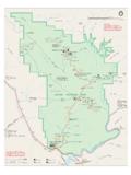
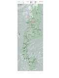
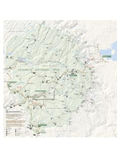
6 Average temperatures at the top: 19 F to 45 F (-7 C to 7 C)Average temperatures at the river: 38 F to 59 F (3 C to 15 C) Hiking Tips Carry over-the-shoe traction devices and use them on icy trails. Wear a warm hat, gloves, wool socks, and synthetic or wool-blend layers. Pack waterproof layers, dry clothes, and socks. Eat warm foods often, such as soup, tea, cocoa, and oatmeal. Know the signs of hypothermia: uncontrolled shivering, confusion, and exhaustion. Put on dry clothing, drink warm liquids, and protect yourself from wind, rain, snow, and to Expect Each SeasonHiking and Camping InformationSouth Kaibab Trailhead: elevation 7200ft (2195m)DestinationElevation Changefrom TopDistance one-wayTime RoundtripOoh Aah Point790ft (230m) ( )1 2 hoursCedar Ridge1120ft (340m) ( )2 4 hoursSkeleton Point2040ft (620m) ( )4 6 hoursThe Tip Off3280ft (1100m) ( )6 9 hoursNorth Kaibab trail junction4700ft (1430m) ( ) 2 DaysBright Angel Campground4700ft (1430m) ( ) 2 DaysThe Bright Angel trail follows Bright Angel Fault down Garden Creek Canyon on a well-maintained trail .
7 Easiest trail , but still incredibly Kaibab Trailhead: elevation 8240ft (2511m)DestinationElevation Change from TopDistance one-wayTime RoundtripCoconino Overlook790ft (240m) ( )1 2 hoursSupai Tunnel1400ft (425m) ( )2 4 hoursRedwall Bridge2200ft (670m) ( )4 6 hoursRoaring Springs Day Use Area3280ft (1000m) ( )6 9 hoursManzanita Rest Area3840ft (1170m) ( )7 10 hoursCottonwood Campground4200ft (1280m) ( )2 daysRibbon Falls4480ft (1365m) ( )2 daysPhantom Ranch Ranger Station5740ft (1750m) ( )3 4 daysBright Angel Campground5740ft (1750m) ( )3 4 daysBright Angel Trailhead: elevation 6840ft (2085m)DestinationElevation Change from TopDistance one-wayTime RoundtripLower Tunnel590ft (180m) ( )1 2 hours1 -Mile Resthouse1120ft (340m) ( )2 4 hours3-Mile Resthouse2120ft (645m) ( )4 6 hoursIndian Garden Campground3040ft (925m) ( )6 9 hoursPlateau Point3080ft (940m) ( )9 12 hours River Resthouse4340ft (1320m) ( )12+ hoursNorth Kaibab trail junction4340ft (1320m) ( )2 daysBright Angel Campground4340ft (1320m) ( ) 2 DaysHiking and Camping Information FunBe CarefulSeek AdviceNorth Kaibab TrailheadCoconino OverlookSupai TunnelRedwall BridgeRoaring SpringsDay Use AreaManzanita Rest AreaCottonwood CampgroundRibbon FallsBright Angel CampgroundTip OffSouth Kaibab TrailheadSkeleton PointCedar RidgeOoh Aah PointRiver ResthouseIndian Garden Campground3-Mile Resthouse1 -Mile ResthouseLower TunnelUpper TunnelBright Angel TrailheadTrail Courtesy1.
8 Travel with a friend and stick Use toilets along the Mules have the right of Uphill hikers have the right of To pass someone in front of you: slow down and let them know you want to pass. 6. Do not store or abandon gear along the trail ; it attracts wildlife. 7. Pack out your Be quiet and respect those who seek North Kaibab trail travels through pine forests and rock outcroppings down Roaring Springs Canyon on a well-maintained South Kaibab trail follows an exposed ridge line with no shade on a well-maintained trail ; best views during a short MapTiyo Point7763ft2366mUncle Jim Point8336ft2541mHattan Butte5973ft1821m7298ft2224mManzanita PointClaude Birdseye Point6981ft2128mTHEABYSSJ ones Point5314ft1620mJohnson Point5313ft1619mSummer Butte5126ft1562mLyell Butte5365ft1635mShoshone Point7300ft2225mKAIBABPLATEAUCOCONINOPLA TEAUTheBattleshipMojave Point6995ft2132mHopi Point7065ft2153mO'Neill Butte6071ft1850mYaki Point7268ft2215mGrandeurPoint7032ft2143m Mather Point7120ft2170mYavapai Point7082ft2159mPowell PointMaricopa PointOsiris Temple6637ft2023mAngels GateBright AngelPointKomo Point8050ft2454 mSHIVA TEMPLE TONTO PLATFORM BRIGHT ANGEL Canyon THE TRANSEPT PHANTOM Canyon THE BOX PHANTOM Canyon ROARING SPRINGS CANYONBRIGHT ANGEL Canyon Bright Angel trail North Kaibab trail North Kaibab trail Tiyo Point trail River trail RimRimTrail TranseptBridlePathTrail trail PointTrail PlateauTontoTrailSouth Kaibab trail Clear
9 Creek TrailDragon Creek Creek Colorado River Pipe Creek Cremation Creek Grapevine Creek Phantom Creek Creek Creek ManzanitaWallCreek AngelBrightCreek AngelBrightBright Angel Creek Bright Angel Wash Creek GardenRibbon FallsGraniteRapidsPipe CreekRapidsGrapevineRapidsDesert View Drive Hermit RoadYaki Point RoadCenter RoadSouth Entrance RoadSouth Entrance RoadMarket Plaza RoadVillage Loop DriveGateTo South Entrance Station and TusayanTo Hermits RestTo Desert View and CameronTo North EntranceStation and Jacob LakeTo Point ImperialRiver ResthousePlateau PointBlack BridgeBridgeBridgeBridgeBridgeBridgeSilv erBridgeIndian Garden3-Mile ResthouseLower Tunnel1 -Mile ResthouseGrand CanyonVisitor CenterMarketCampgroundClinicCottonwood Bright AngelThe TipoffSkeleton PointCedar RidgeOoh Aah PointPhantom Ranch4040ft1231m4400ft1341m6040ft1840m37 60ft1146 m6840ft2085m7450ft2270m8161ft2487mGenera l StoreCampgroundBackcountryInformationCen terEl TovarVerkamps Visitor CenterGrand Canyon LodgeNorth Rim Visitor CenterCoconino OverlookSupai TunnelRedwall BridgeRoaring Spring JunctionRibbon Falls junctionManzanita Rest AreaAdministrationand BackcountryOfficeStation 3 Bldg8241ft2510m7200ft2195m6840ft2085m380 0ft1158m3760ft1146m2500ft762m3920ft1195m 5160ft1573m6080ft1853m6440ft1963mCanteen Ranger StationRanger StationFull services May 15 to October 15;located miles ( km) RIMS ervices available RIMS outh Kaibab Trailhead closedto private vehicles.
10 Access onlyvia free shuttle not swim in the ColoradoRiver! You could drown due todangerous currents and extremelycold water temperatures. North KaibabTrailheadSouth KaibabTrailheadBright Mile1 KilometerFirst aidEmergency phoneRanger Station: Year-roundToiletRanger Station: SeasonalCampgroundCamp in designated sites only;permit requiredDrinking Water: Seasonal; checkavailabilityDrinking Water: Year-RoundAlways carry backup water purificationNorthOther trailFeatured trailRoadFood servicePurple shuttle routeBlue shuttle routeRed shuttle routeOrange shuttle routeDestinationElevation changefrom topDistance one-wayTime round-tripCoconino OverlookSupai TunnelRedwall BridgeManzanita Rest AreaCottonwood CampgroundRibbon FallsPhantom Ranch Ranger StationBright Angel Campground240 m425 m670 m1170 m1280 m1365 m1750 m1750 m790 ft1400 ft2200 ft3840 ft4200 ft4480 ft5740 ft5740 mi1 2 hours2 4 hours4 6 hours7 10 hours2 days2 days3-4 days3-4 daysNorth Kaibab trail : Trailhead elevation 8240ft (2511m)Good shade and cover from wind and lightning; seasonal water.