Transcription of History and GeoGrapHy The Geography of the United States
1 History and GeoGrapHy The GeoGrapHy of the United States Reader Statue of Liberty Grand canyon Arizona desert Great Smoky Mountains THIS BOOK IS THE PROPERTY OF: STATE. Book No. PROVINCE Enter information COUNTY in spaces to the left as PARISH instructed. SCHOOL DISTRICT. OTHER. CONDITION. Year ISSUED TO Used ISSUED RETURNED. PUPILS to whom this textbook is issued must not write on any page or mark any part of it in any way, consumable textbooks excepted. 1. T eachers should see that the pupil's name is clearly written in ink in the spaces above in every book issued. 2. The following terms should be used in recording the condition of the book: New; Good; Fair; Poor; Bad. The GeoGrapHy of the United States Reader Creative Commons Licensing This work is licensed under a Creative Commons Attribution-NonCommercial-ShareAlike International License.
2 You are free: to Share to copy, distribute, and transmit the work to Remix to adapt the work Under the following conditions: Attribution You must attribute the work in the following manner: This work is based on an original work of the Core Knowledge Foundation ( ) made available through licensing under a Creative Commons Attribution-NonCommercial-ShareAlike International License. This does not in any way imply that the Core Knowledge Foundation endorses this work. Noncommercial You may not use this work for commercial purposes. Share Alike If you alter, transform, or build upon this work, you may distribute the resulting work only under the same or similar license to this one. With the understanding that: For any reuse or distribution, you must make clear to others the license terms of this work.
3 The best way to do this is with a link to this web page: Copyright 2018 Core Knowledge Foundation All Rights Reserved. ISBN: 978-1-68380-216-7. Core Knowledge , Core Knowledge Curriculum Series , Core Knowledge History and GeoGrapHy and CKHG . are trademarks of the Core Knowledge Foundation. Trademarks and trade names are shown in this book strictly for illustrative and educational purposes and are the property of their respective owners. References herein should not be regarded as affecting the validity of said trademarks and trade names. The GeoGrapHy of the United States Table of Contents Chapter 1 The United States .. 2. Chapter 2 New England.. 8. Chapter 3 The Mid-Atlantic Region.. 16. Chapter 4 The South.. 24. Chapter 5 The Midwest .. 32. Chapter 6 The Great Plains.
4 38. Chapter 7 The Rocky Mountain Region.. 44. Chapter 8 The Southwest.. 52. Chapter 9 The West Coast .. 58. Chapter 10 Alaska and Hawaii .. 66. Cool Facts .. 74. Glossary .. 76. The GeoGrapHy of the United States Reader Core Knowledge History and GeoGrapHy 5. Chapter 1. The United States Exploring the United States The Big Question of America The United States , How does the excluding Alaska and Hawaii, narrator describe the stretches about three thousand location of the United miles from coast to coast or east States in relation to Earth's hemispheres, to west. Because of its great size, continents, and it is often divided into smaller oceans? geographical Vocabulary areas, or regions. The States in each region, n. an area region have many things in common, of Earth's surface such as GeoGrapHy , including that has some unique geographic climate, natural resources, characteristic that economic activity, and other sets it apart from other areas important geographical conditions.
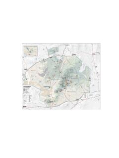
5 GeoGrapHy , n. the physical and human Mission: Explore Earth features of a place As you know, Admiral Zorg, the spaceship natural resource, n. something from that I command has been exploring the nature that is useful planet known as Earth for almost a year. We to humans have discovered that Earth is very different from our planet Proteus. 2. Regions of the United States 0 500 miles Canada ME. WA. MT ND VT. MN. NH. OR. NY MA. WI. ID SD RI. MI. CT. WY. IA PA NJ. NE OH DE. NV IL IN. WV MD. UT. CO VA Washington, KS MO. CA KY NC N. TN W. OK SC E. PACIFIC AZ NM AR. S. OCEAN AL GA. MS. ATLANTIC. TX LA OCEAN. FL. Gulf of Mexico AK National capital New England Mid-Atlantic Midwest HI. Mexico Great Plains South Southwest Rocky Mountain West Coast Alaska and Hawaii 3.
6 This map shows the regions of the United States . Which region is your state located in? We have studied its interesting physical features and life forms and reported our observations to you. Now, as our year of exploring draws to a close, there is one last place to explore the United States of America. We will explore and report on each area of the United States . In each report we will answer questions such as: Which States make up each region? What does the land look like in this region? What plants and animals live there? What is the weather like? What kinds of jobs do people do? What do people eat and drink? What do they do for fun? These are the regions we will report from: New England, the Mid-Atlantic, the South, the Midwest, the Great Plains, the Rocky Mountains, the Southwest, and the West Coast.
7 There are also two States that do not belong to a region because they are not connected to any other state. They are called Alaska and Hawaii. We will send a separate report about these two States . We will gather information for our reports through observation. When we have questions, we will talk to some of the people we meet. (Of course, we will always remember to be disguised as humans!). Right now, as I record this audio message, we are flying over a huge body of water called the Atlantic Ocean. The next land we see will be the United States of America. A Vast and Varied Country The United States of America is reported to be a huge country. Earthlings in other places have described it as having a great 4. variety of landforms and life forms.
8 In Vocabulary addition to the indigenous peoples who landform, n. a have lived there for thousands of years, natural physical and the descendants of the first European feature on Earth's surface settlers, I have heard that people travel from all over the world to live there. indigenous, adj. native to a particular region As we fly over the Atlantic Ocean, we will be or environment looking at maps of the United States . These Native Americans lived in the United States for thousands of years before the first European settlers arrived. 5. maps will help us find the places we want to go. They will also help us to identify the different regions of this vast country. You remember, Admiral, that Earth is shaped like a globe, or sphere. Earthlings divide their world into half-globes, or hemispheres.
9 They speak of an Eastern Hemisphere and a Western Hemisphere. The United States is in the Western Hemisphere on the continent called North America. A continent is a large landmass that sometimes has islands off its shores. North America is made up of Canada, the United States , and Middle America, which includes Mexico, Central America, and the Caribbean islands. Looking at our maps, we see that, excluding Alaska and Hawaii, the United States stretches all the way across the continent of North America a distance of about three thousand miles. On each side of the country, there is a huge body of water called an ocean. On the east side, the United States is bordered by the Atlantic Ocean. On the west side, it is bordered by the Pacific Ocean. The United States also controls territories beyond these borders.
10 In the Caribbean Sea, which is south of the United States , Puerto Rico and the Virgin Islands are territories. In the Pacific Ocean, Guam, American Samoa, and the Northern Mariana Islands are all territories. We will not be sending reports about these territories. Lieutenant Koola just informed me that she has sighted land below us. She is pretty sure that it is the state of Maine in the northeastern United States . Our map shows that the country is divided into fifty smaller units, or States . I expect that's why the country is called the United States ! 6. Each of the fifty States has its own government and its own capital city. This is because the United States is a democracy. In other words, it has a system of government in which the people rule through elected representatives.