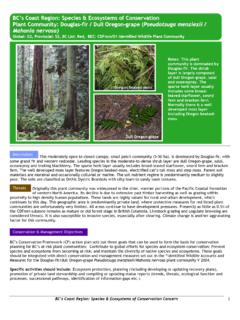
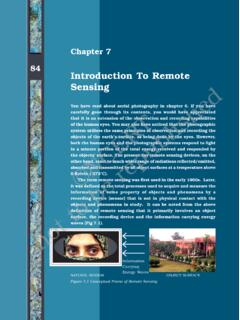
Transcription of HISTORY OF REMOTE SENSING - Department of Geography
1 HISTORY OF REMOTE SENSINGIMPORTANT PERIODS The beginning: photography and flight (1858-1918) Rapid developments in photogrammetry (1918-1939) Military imperatives (1939-1945) Cold wars and environmental concerns (1946-1971) Dawning of a new age (1972-1986) Commercialization, and geo-location (1986-1999) No place left to hide (2000-future)STEPPING STONES 5th-4th Centuries and Greek philosophers describe the basic principles of optics and the camera. 1664-1666 Isaac Newton discovered that white light is composed of different colors. 1727 Johann Heinrich Schulze discovered that silver nitrate darkened upon exposure to light. Sun pictures LEADING TO .. 1814 Joseph Niepceachieves first photographic image with camera obscura- however, the image required eight hours of light exposure and later faded.
2 1837 Louis Daguerre's first daguerreotype - the first image that was fixed and did not fade and needed under thirty minutes of light du temple 1838 WORLD S OLDEST PHOTOGRAPHP hotography (as we know it) light drawing invented in the early1800 sView from the Window at Le Gras" (circa 1826)PHOTOGRAPHIC EXPLORATIONS From the beginning, the potential of aerial photography for topographic mapping was clear Early platforms used for aerial photos included: balloons pigeons kites ROCKETS, FROM 1897 ONA photo taken byAlfred Nobel in 1897,from a rocketPhotos of and byAlfred Maul s rocket,launched in 1904 AERIAL PHOTOGRAPHY ENGAGESSan Francisco after the earthquake and fire of 1906 (bottom photo) kite BECOMES A REALITY1903 the first flightThe advantages affordedby aerial surveillance quickly become apparentduring First World AERIAL PHOTOGRAPHSB oston in 1860 London in the 1920 sTHE YEARS BETWEEN THE WARS After the war, planes and pilots and cameras spread widely Development of photogrammetric hardware (analog stereoplotters)
3 Widespread use of aerial photos in forest inventory, geologic mapping, soil surveys Close cooperation between military and non-military groups in advancing the use of aerial photographyTHE SECOND WORLD WAR (1939-1945) Aerial photography emerges as a key military asset Photo interpretation becomes a fine art Photogrammetric equipment makes great strides Colour infrared film is developed and used for camouflage detection radar is operationalized REMOTE SENSING becomes a classified technologyIR FILM: REVEALING THE HIDDENRADAR: MICROWAVES, OUT OF THE OVENTHE COLD WAR YEARS (1945-1971) Military photo interpreters apply their skills to civilian topographic mapping, geology and engineering New platforms emerge, such as spy planes (U-2) and rockets / satellites imaging systems are developed (replacing film-based devices) for radar and multispectral scanners The politics of REMOTE SENSING become an international issue (open skies?)
4 Nyet)SCANNING VSFRAME-BASED SENSORS analogdigitalNEW PLATFORMS, TECHNOLOGIESSide-looking airborne radarCoronaWEATHER SATELLITESThe first nonmilitary earth observing satellite was designed to transmit television pictures back to earth showing broad weather patterns (1960).EMERGING ENVIRONMENTAL CONCERNS Geographic Information Systems are developed Environment Canada s CGIS (early 60 s) Harvard Graphics Lab s SYMAP US Census DIME Ian McHarg s(1969) Design with Nature published Bibby& Mackney(1969) Land use capability classificationSYMAP outputMylaroverlaysDAWNING OF A NEW AMERICAN AGE From the early 70 s to the mid 80 s, REMOTE SENSING promised much, but had trouble fully delivering on that promise More open cooperation with researchers Multiple satellite-based sensors launched LANDSAT (monitoring land resources) AVHRR (monitoring meteorological conditions) SeaSat(oceanographic research using radar ) TOMS (ozone mapping)Ozone hole overthe AntarcticMount St.
5 Helensbefore and afterLandsat cover mappingThe temperature ofthe Great Lakes in patternsover North AmericaCOMMERCIALIZATION EMERGES France launches the first non-US, non-Russian satellite in 1986 (SPOT) providing the highest resolution, commercially-available imagery, at the time (10 m panchromatic) SPOT allowed for off-nadir viewing, enabling stereoscopic coverage to be collected GIS use explodes GPS developedGIS integrates disciplines and technologies such as REMOTE SENSING , surveying,photogrammetry, spatial analysis, cartography, computer integratesdisciplinesGEOGRAPHY INTEGRATES DATAGEOLOCATIONFOR ALL (AKA GPS) Originally developed for the military to enable locationalawareness Originally the signal was fuzzified so that civilian users couldn t get accurate results A simple explanation of how GPS works (video)NO PLACE LEFT TO HIDE (2000 ON) Ever-higher image resolutions - GPS in every cell phone, car, backpack All appliances linked to the web, RFIDs everywhereSensor Nets: The National Ecological Observatory NetworkWHAT CAN THE MILITARY SEE?
6 10 m (SPOT) 3 m 1 mRoman Colosseum, taken from 680 km in spaceby the GeoEye-1 commercial satellite ( m resolution)INNOVATIVE PLATFORMS AND USESIN SUMMARYP rior to the Space Age (1960)Since1960 Onlyone kind and date of data (a photograph)Many kinds and dates of REMOTE SENSING dataReliance on human interpretationRelianceon automated analysisSimpleand inexpensive equipmentComplex and expensive equipmentAnalysis conductedby those in the field Analysis conducted by REMOTE SENSING expertsLittle concern about renewable resources, environmental protection, globalresource information systemsIncreasing concernabout renewable resources, environmental protection and the need to develop global resource information systemsControlled accessUniversal access (to some)
7 IN SUMMARY REMOTE SENSING will only become more important but also more invasive in our future None-the-less, it remains an important source of data for environmental monitoring, urban development, human rights watch, climate change, geological exploration, and much muchmore. A tension exists between the surveillance aspects and the environmental benefitsLANDSAT 7: BRANDBERGMASSIF NAMIBIALANDSAT 7: VON KARMAN VORTICESMONITORING FOREST LOSSP apua New Guinea s Gulf Province. The 1988 image (left) shows an intact rainforest, while the 2002 image (right) shows the impact of logging that began in 1995. HUMAN RIGHTS WATCHP ortaFarm, located just west of the Zimbabwean capital of Harareover 850 homes and up to 10,000 peopleJune 2002 April 2006